
Sri Jayewardenepura Kotte, commonly known as Kotte, is the legislative capital of Sri Lanka. Sri Jayawardenepura Kotte is located adjacent to the urban area of Sri Lanka's de facto economic, executive, and judicial capital, Colombo.
Padukka is a town in the district of Colombo in the Western Province of Sri Lanka. It has a population of roughly 8,000. Elevation 44feet.

Kegalle is a large town in Sabaragamuwa Province of Sri Lanka. It is located on the Colombo–Kandy road, approximately 78 km (48 mi) from Colombo, 40 km (25 mi) from Kandy, 32 km (20 mi) from Kurunegala and 46 km (29 mi) from Avissavella. It is the main town in the Kegalle District, which is one of two districts which comprise Sabaragamuwa Province. The town is governed by an Urban Council.

Mawanella is a town which belongs to the Kegalle district in the Sabaragamuwa Province of Sri Lanka. It lies between Kegalle and Kadugannawa along the Colombo-Kandy road. The area consists of four administrative areas, namely Mawanella, Aranayake, Rambukkana and Hemmathagama.
Ratnapura is a major city in Sri Lanka. It is the capital city of Sabaragamuwa Province, as well as the Ratnapura District, and is a traditional centre for the Sri Lankan gem trade. It is located on the Kalu Ganga in south-central Sri Lanka, some 101 km (63 mi) southeast of the country's capital, Colombo. Ratnapura is also spelled as Rathnapura.

Gampaha is an urban city in Gampaha District, Western Province, Sri Lanka. It is situated to the north-east of the capital Colombo. It is the sixth largest urban area in Western Province, after Colombo, Negombo, Kalutara, Panadura and Avissawella. Gampaha is also the second largest municipal centre in Gampaha district, after Negombo. Gampaha has a land area of 25.8 ha and is home to the offices of 75 government institutions.
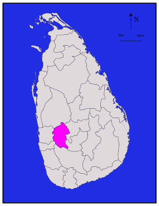
Kegalle is a district in Sabaragamuwa Province, Sri Lanka. It is one of 25 districts of Sri Lanka, the second level administrative division of the country. The district is administered by a District Secretariat headed by a District Secretary appointed by the central government of Sri Lanka. It was a former Dissavani of Sri Lanka.
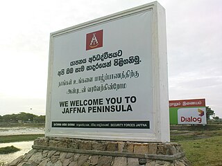
The Jaffna Peninsula is a region in the Northern Province of Sri Lanka. It is home to the capital city of the province, Jaffna, and comprises much of the former land mass of the medieval Jaffna Kingdom.

The primary form of agriculture in Sri Lanka is rice production. Rice is cultivated during Maha and Yala seasons. Tea is cultivated in the central highlands and is a major source of foreign exchange. Vegetables, fruits and oilseed crops are also cultivated in the country. There are two Agriculture Parks abbreviated as A. Parks established by the Department of Agriculture. Out of the total population in Sri Lanka, 27.1% engages in agricultural activities. Agriculture accounted for 7.4% of the GDP in 2020.
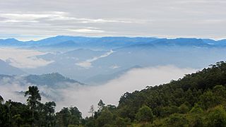
Bandarawela is the second largest town in the Badulla District which is 28 km (17 mi) away from Badulla. Bandarawela is 200 km (120 mi) away from Colombo and about 125 km (78 mi) away from Kandy, the two largest cities of Sri Lanka. Thanks to its higher altitude, compared to surrounding locations, Bandarawela has milder weather conditions throughout the year making it a tourist destination for locals. Bandarawela is within hours reach of surrounding towns and cities by both road and rail. The town is influenced by its colonial history and rests among dense, lush forestation occupying a niche among visitors as a base for tourism.

Balangoda is a town in Ratnapura District, Sabaragamuwa Province, Sri Lanka, governed by an urban council located 143 kilometres (89 mi) away from Colombo and 43 kilometres (27 mi) from Ratnapura on Colombo - Batticaloa Highway(A4). It is one of the largest towns of the Sabaragamuwa Province. According to the 2001 census, Balangoda has a population of 16,875 and area of 16.2 km2.
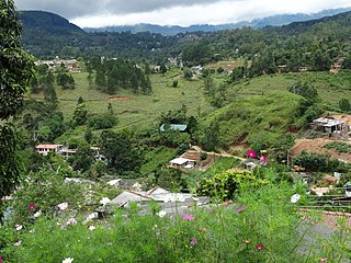
Rathkarawwa is a village in Welimada Divisional Secretariat in Badulla District, Sri Lanka with a population of about 1000. The nearest city to Rathkarawwa is Haputale, which is about 10 km in distance. Rathkarawwa is surrounded by Welimada, Haputale and Diyatalawa towns. Paddy and vegetable cultivation had been the main source of income for many families for decades.

The Central Province is one of the nine provinces of Sri Lanka. The province has an area of 5,674 km2 and a population of 2,421,148, making it the 2nd most populated province. The city of Kandy is the capital of the province.

Katugastota is a suburb of the city of Kandy in Kandy District, Central Province of Sri Lanka. It is located along the Kandy-Jaffna A9 highway approximately 4 km (2.5 mi) from the city center of Kandy. Katugastota is one of the three main entry points to the city of kandy. Two major Highways meet at the center of the city which makes Katugastota one of the busiest suburbs in Kandy district.
Malimbada Divisional Secretariat is a Divisional Secretariat of Matara District, of Southern Province, Sri Lanka.
Dodangoda Divisional Secretariat is a Divisional Secretariat of Kalutara District, of Western Province, Sri Lanka.
Baduraliya is a town in the Kalutara District in Sri Lanka. It is approximately 82 km (51 mi) from Colombo and 58 km (36 mi) from Rathnapura. Baduraliya was named after a rally against taxes. "Badu" in Sinhala means taxes and “raliya” means a rally. Baduraliya is surrounded by tea plantations and rubber estates, and it is at an altitude of 27 m (89 ft) above sea level.

Ingiriya is a city in Kalutara District of Western Province, Sri Lanka, near the border with Sabaragamuwa Province. The city is the meeting point of the Rathnapura–Panadura, Ingiriya–Padukka and Ingiriya–Bulathsinhala roads.

Sammanthurai, is a town in Ampara District of Eastern Province of Sri Lanka. Sammanthurai situated at 7°22′0″N81°48′0″E, is 4.8 km west of the Bay of Bengal coast. It lies between the towns of Ampara and Karaitivu along the A31 road. It is surrounded by paddy fields and it is renowned for its rice paddies and its inner harbour from ancient times.
Walapane is a town located in Nuwara Eliya District of Sri Lanka. It is a high country area with many green mountains. It was called Wathtumulla in the past. The name Watumulla derived from the former tea factory which was located in the heart of the Walapane town and now demolished since the production of Wattumulla Plantation declined. Walapane is administered by the government of *Sri Lanka through *Walapane Divisional Secretariat.
