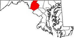
Discovery-Spring Garden, Maryland

Last updated
Discovery-Spring Garden, Maryland
Frederick County Maryland Incorporated and Unincorporated areas Discovery-Spring Garden Highlighted.svg
Coordinates: 39°27′50″N77°21′38″W / 39.46389°N 77.36056°W / 39.46389; -77.36056
CountryFlag of the United States.svg  United States
State Flag of Maryland.svg  Maryland
County Flag of Frederick County, Maryland.svg Frederick
Area
  Total1.0 sq mi (2.5 km2)
  Land1.0 sq mi (2.5 km2)
  Water0.0 sq mi (0.0 km2)
Population
 (2000)
  Total2,152
  Density2,259/sq mi (872.1/km2)
Time zone UTC−5 (Eastern (EST))
  Summer (DST) UTC−4 (EDT)
ZIP code
21793
Area code(s) 301, 240
FIPS code 24-23005

Discovery-Spring Garden is a former census-designated place in Frederick County, Maryland, United States. It is the combination of the two unincorporated communities of Discovery and Spring Garden. As of the 2000 census, the population was 2,152; its population was not counted in 2010.

Contents

Geography

Discovery-Spring Garden is located at 39°27′50″N77°21′38″W / 39.46389°N 77.36056°W / 39.46389; -77.36056 (39.463960, 77.360581). [1]

According to the United States Census Bureau, in 2000 the CDP had a total area of 0.9 square miles (2.3 km2), all land.

Demographics

As of the census [2] of 2000, there were 2,152 people, 712 households, and 596 families residing in the CDP. The population density was 2,258.8 inhabitants per square mile (872.1/km2). There were 731 housing units at an average density of 767.3 per square mile (296.3/km2). The racial makeup of the CDP was 88.48% White, 7.53% African American, 0.05% Native American, 1.25% Asian, 0.09% Pacific Islander, 0.74% from other races, and 1.86% from two or more races. Hispanic or Latino of any race were 1.58% of the population.

There were 712 households, out of which 44.7% had children under the age of 18 living with them, 63.5% were married couples living together, 15.9% had a female householder with no husband present, and 16.2% were non-families. 12.6% of all households were made up of individuals, and 2.1% had someone living alone who was 65 years of age or older. The average household size was 3.02 and the average family size was 3.26.

In the CDP, the population was spread out, with 31.5% under the age of 18, 7.4% from 18 to 24, 30.3% from 25 to 44, 25.7% from 45 to 64, and 5.1% who were 65 years of age or older. The median age was 34 years. For every 100 females, there were 96.4 males. For every 100 females age 18 and over, there were 91.4 males.

The median income for a household in the CDP was $50,656, and the median income for a family was $52,000. Males had a median income of $37,500 versus $27,409 for females. The per capita income for the CDP was $18,704. About 1.5% of families and 2.9% of the population were below the poverty line, including 2.4% of those under age 18 and none of those age 65 or over.

Related Research Articles

<span class="mw-page-title-main">Spring Garden, California</span> Census-designated place in California, United States

Spring Garden is a census-designated place (CDP) in Plumas County, California, United States. The population was 16 at the 2010 census, down from 55 at the 2000 census.

<span class="mw-page-title-main">Clover Hill, Maryland</span> Unincorporated community in Maryland

Clover Hill is an unincorporated community and former census-designated place (CDP) in Frederick County, Maryland, United States. The population was 3,260 at the 2000 census. The area was not listed as a CDP for the 2010 census, and no population total was published.

<span class="mw-page-title-main">Halfway, Maryland</span> CDP in Maryland, United States

Halfway is a census-designated place (CDP) in Washington County, Maryland, United States. The population was 11,896 at the 2020 census. It is named due to its location, which is halfway between Hagerstown and Williamsport. As a major suburb of Hagerstown, Halfway is part of the Hagerstown-Martinsburg, MD-WV, Metropolitan Statistical Area.

<span class="mw-page-title-main">Highfield-Cascade, Maryland</span> CDP in Maryland, United States

Highfield-Cascade is a census-designated place (CDP) in Washington County, Maryland, United States. The CDP encompasses two closely-spaced unincorporated communities, Highfield and Cascade, which are usually referred to separately. The population of the combined CDP was 1,141 at the 2000 census.

<span class="mw-page-title-main">Mount Lena, Maryland</span> CDP in Maryland, United States

Mount Lena is a census-designated place (CDP) in Washington County, Maryland, United States. The population was 501 at the 2000 census.

<span class="mw-page-title-main">Robinwood, Maryland</span> CDP in Maryland, United States

Robinwood is a census-designated place (CDP) in Washington County, Maryland, United States. The population was 4,731 at the 2000 census. It is a part of the Hagerstown Metropolitan Area. Robinwood is home to Hagerstown Community College.

<span class="mw-page-title-main">San Mar, Maryland</span> CDP in Maryland, United States

San Mar is a census-designated place (CDP) in Washington County, Maryland, United States. The population was 515 at the 2000 census.

<span class="mw-page-title-main">St. James, Maryland</span> CDP in Maryland, United States

St. James is a census-designated place (CDP) in Washington County, Maryland, United States. The population was 1,657 at the 2000 census. It is also the home of St. James School, Hagerstown, a small, Episcopalian, boarding school. St. James was formerly named "Lydia."

<span class="mw-page-title-main">Reserve, Montana</span> CDP in Montana, United States

Reserve is a census-designated place (CDP) in Sheridan County, Montana, United States. The population was 23 at the 2010 census.

<span class="mw-page-title-main">Silver Springs, Nevada</span> Census-designated place in Nevada, United States

Silver Springs is a census-designated place (CDP) in Lyon County, Nevada, United States at the intersection of US 50 and US 95A. The population was 5,296 at the 2010 census. Lahontan Reservoir, Lahontan State Recreation Area and historic Fort Churchill State Historic Park are all located nearby. The area is served by the Silver Springs Airport.

<span class="mw-page-title-main">Labish Village, Oregon</span> Unincorporated community in the state of Oregon, United States

Labish Village is a census-designated place (CDP) in Marion County, Oregon, United States. The population was 454 at the 2020 census. It is part of the Salem Metropolitan Statistical Area.

Wayne Heights is a census-designated place (CDP) in Franklin County, Pennsylvania, United States. The population was 2,606 at the 2020 census.

<span class="mw-page-title-main">Garden View, Pennsylvania</span> Census-designated place in Pennsylvania, United States

Garden View is a census-designated place (CDP) in Lycoming County, Pennsylvania, United States. The population was 2,503 at the 2010 census. It is part of the Williamsport Metropolitan Statistical Area.

Yeagertown is a census-designated place (CDP) in Mifflin County, Pennsylvania, United States. The population was 1,035 at the 2000 census.

<span class="mw-page-title-main">Grantley, Pennsylvania</span> CDP in Pennsylvania, United States

Grantley is a census-designated place (CDP) in York County, Pennsylvania, United States. The population was 3,628 at the 2010 census.

<span class="mw-page-title-main">Valley View, York County, Pennsylvania</span> CDP in Pennsylvania, United States

Valley View is a census-designated place (CDP) in York County, Pennsylvania, United States. The population was 2,817 at the 2010 census.

<span class="mw-page-title-main">Zapata Ranch, Texas</span> CDP in Texas, United States

Zapata Ranch is a census-designated place (CDP) in Willacy County, Texas, United States. The population was 108 at the 2010 census.

Cassville is a census-designated place (CDP) in Monongalia County, West Virginia, United States. The population was 1,268 at the 2020 census. It is included in the Morgantown, West Virginia Metropolitan Statistical Area. Cassville was named after Lewis Cass, a prominent American statesman who served as Secretary of War, Secretary of State, and Governor of Michigan.

Alpine Northeast is a census-designated place in Lincoln County, Wyoming, United States. The population was 196 at the 2010 census.

<span class="mw-page-title-main">Kennebunk (CDP), Maine</span> Census-designated place in Maine, United States

Kennebunk is a census-designated place (CDP) comprising the central village in the town of Kennebunk in York County, Maine, United States. The population was 5,214 at the 2010 census, out of a total town population of 10,798. It is part of the Portland–South Portland–Biddeford, Maine Metropolitan Statistical Area.

References

  1. "US Gazetteer files: 2010, 2000, and 1990". United States Census Bureau. 2011-02-12. Retrieved 2011-04-23.
  2. "U.S. Census website". United States Census Bureau . Retrieved 2008-01-31.