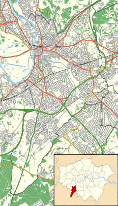
Kingston upon Thames is a town in the Royal Borough of Kingston upon Thames, southwest London, England. It is situated on the River Thames and 10 miles (16 km) southwest of Charing Cross. It is notable as the ancient market town in which Saxon kings were crowned and today is the administrative centre of the Royal Borough of Kingston upon Thames.

Staines-upon-Thames is a market town in northwest Surrey, England, around 17 mi (27 km) west of central London. It is in the Borough of Spelthorne, at the confluence of the River Thames and Colne. Historically part of Middlesex, the town was transferred to Surrey in 1965. Staines is close to Heathrow Airport and is linked to the national motorway network by the M25 and M3.

Hampton is a suburban area on the north bank of the River Thames, in the London Borough of Richmond upon Thames, England, and historically in the County of Middlesex. which includes Hampton Court Palace. Hampton is served by three railway stations, including one immediately south of Hampton Court Bridge in East Molesey.

Norbiton is an area within the Royal Borough of Kingston upon Thames, London. It lies approximately 1 mile (1.6 km) east of Kingston upon Thames town centre, and 11 miles (17.7 km) from Charing Cross. Its main landmarks include Kingston Hospital, Kingsmeadow football stadium, Kingston Cemetery and St Peter's Anglican parish church which serves the area.
Richmond is a town in south-west London, 8.2 miles (13.2 km) west-southwest of Charing Cross. It stands on a meander of the River Thames, and features many parks and open spaces, including Richmond Park, and many protected conservation areas, which include much of Richmond Hill. A specific Act of Parliament protects the scenic view of the River Thames from Richmond.

Putney Bridge is a Grade II listed bridge over the River Thames in west London, linking Putney on the south side with Fulham to the north. The bridge has medieval parish churches beside its abutments: St Mary's Church, Putney is built on the south and All Saints Church, Fulham on the north bank. This close proximity of two churches by a major river is rare, another example being at Goring-on-Thames and Streatley, villages hemmed in by the Chiltern Hills. Before the first bridge was built in 1729, a ferry had shuttled between the two banks.

The White Hart was the personal badge of Richard II, who probably derived it from the arms of his mother, Joan "The Fair Maid of Kent", heiress of Edmund of Woodstock. It may also have been a pun on his name, as in "Rich-hart". In the Wilton Diptych, which is the earliest authentic contemporary portrait of an English king, Richard II wears a gold and enamelled white hart jewel, and even the angels surrounding the Virgin Mary all wear white hart badges. In English Folklore, the white hart is associated with Herne the Hunter.

Sunbury-on-Thames is a suburban town on the north bank of the River Thames in the Borough of Spelthorne, Surrey, centred 13 mi (21 km) southwest of central London. Historically part of the county of Middlesex, in 1965 Sunbury and other surrounding towns were initially intended to form part of the newly created county of Greater London but were instead transferred to Surrey. Sunbury adjoins Feltham to the north, Hampton to the east, Ashford to the northwest and Shepperton to the southwest. Walton-on-Thames is to the south, on the opposite bank of the Thames.

Coombe is a historic neighbourhood in the Royal Borough of Kingston upon Thames in south west London, England. It sits on high ground, east of Norbiton. Most of the area was part of the former Municipal Borough of Malden and Coombe before local government re-organisation in 1965. It now shares borders with the boroughs of Merton and Sutton with, to the north, the small, inter-related neighbourhoods of Kingston Hill and Kingston Vale, beyond which is Richmond Park in Richmond; and Roehampton/Putney Vale in Wandsworth. To the east are public playing fields and Wimbledon Common.
Shiplake consists of three settlements: Shiplake, Shiplake Cross and Lower Shiplake. Together these villages form a civil parish situated beside the River Thames 2 miles (3 km) south of Henley-on-Thames, Oxfordshire, England. The river forms the parish boundary to the east and south, and also the county boundary between Oxfordshire and Berkshire. The villages have two discrete centres separated by agricultural land. The 2011 Census records the parish population as 1,954 and containing 679 homes. The A4155 main road linking Henley with Reading, Berkshire passes through the parish.
Ham is a suburban district in Richmond, south-west London. It has meadows adjoining the River Thames where the Thames Path National Trail also runs. Most of Ham is in the London Borough of Richmond upon Thames and, chiefly, within the ward of Ham, Petersham and Richmond Riverside; the rest is in the Royal Borough of Kingston upon Thames. The district has modest convenience shops and amenities, including a petrol station and several pubs, but its commerce is subsidiary to the nearby regional-level economic centre of Kingston upon Thames.

Ewell is a town in the Borough of Epsom and Ewell in Surrey, England. It is approximately 12 miles (19 km) south of central London and 2 miles (3.2 km) northeast of Epsom. In the 2011 Census, the town had a population of 34,872. The majority of which (73%) is in the ABC1 social class, except the Ruxley Ward that is C2DE.

Richmond Green is a recreation area near the centre of Richmond, a town of about 20,000 inhabitants situated in south-west London. Owned by the Crown Estate, it is leased to the London Borough of Richmond upon Thames. The Green, which has been described as "one of the most beautiful urban greens surviving anywhere in England", is roughly square in shape and its open grassland, framed with broadleaf trees, extends to roughly twelve acres. On the north-east side there is also a smaller open space called Little Green. Richmond Green and Little Green are overlooked by a mixture of period townhouses, historic buildings and municipal and commercial establishments including the Richmond Lending Library and Richmond Theatre.

The Coronation Stone is an ancient sarsen stone block which is believed to have been the site of the coronation of seven Anglo-Saxon kings. It is currently located next to the Guildhall in Kingston upon Thames, England. Kingston is now a town in the Royal Borough of Kingston Upon Thames in Greater London.
Strand-on-the-Green is one of Chiswick's four medieval villages, and a "particularly picturesque" riverside area in West London. It is a conservation area, with many "imposing" listed buildings beside the River Thames; a local landmark, the Kew Railway Bridge that crosses the River Thames and the Strand, is itself Grade II listed. Oliver's Island is just offshore.

Longworth is a village and civil parish in the Vale of White Horse, England. Historically within what was the north-west projection of Berkshire, boundary changes transferred it to Oxfordshire in 1974. The village is between Faringdon, 7 miles (11 km) to the west, and Oxford, 9 miles (14 km) to the northeast. The 2021 Census recorded the parish's population as 543.

The Kingston upon Thames Guildhall is a municipal building in Kingston upon Thames in England. It is situated in the High Street, adjacent to the Hogsmill River. The guildhall, which is the headquarters of Kingston upon Thames London Borough Council, is a Grade II listed building.

The Old Ship is a Grade II listed public house at 3 King Street, Richmond in the London Borough of Richmond upon Thames. It was built in the 18th century, and the architect is not known. Prior to 1725 it was known as the Six Bells: it acquired its present name in the 1780s and has been a Young's pub since 1860.
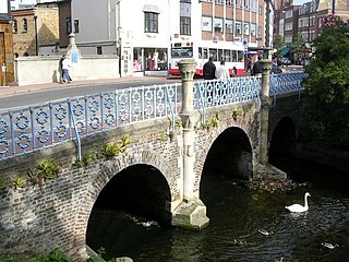
The Clattern Bridge is a bridge over the Hogsmill River in Kingston upon Thames. It was built around 1175 and is thus one of the oldest intact bridges in England. It replaced an older Saxon bridge which was known as the Clatrung Bridge. Its various names, such as the Clateryngbrugge, are thought to derive from the clattering of horses' hooves as they crossed the bridge. The bridge still carries a full load of modern vehicle traffic.

Kingston upon Thames War Memorial, in the Memorial Garden on Union Street, Kingston upon Thames, London, commemorates the men of the town who died in the First World War. After 1945, the memorial was updated to recognise casualties from the Second World War. The memorial was commissioned by the town council and was designed by the British sculptor Richard Reginald Goulden. The memorial includes a bronze statue of a nude warrior, carrying a flaming cross and wielding a sword with which he defends two children from a serpent, erected on a granite plinth, with bronze plaques listing the names of the dead. Goulden designed a number of such allegorical memorials, including others at Crompton, Greater Manchester, and Redhill, Surrey. The Kingston memorial was designated a Grade II listed structure in 1983. This was revised upwards in 2016 to Grade II*, denoting a building or structure of particular importance.