
The Bush Hill Historic District encompasses a historic rural landscape in central northern Brooklyn, Connecticut. It extends along parts of Bush Hill Road, Connecticut Route 169, and Wolf Den Road. The area has a remarkable concentration of farmhouses and agricultural outbuildings dating to the early 19th century or earlier. The district was listed on the National Register of Historic Places in 1987.

The Hampton Hill Historic District encompasses the historic village center of Hampton, Connecticut, a small rural community in Windham County. It is a linear district, extending for about 1 mile (1.6 km) along Connecticut Route 97, the major north-south route through the town, and laid out as a tree-lined boulevard. Most of the district's 62 historic buildings were built in the 19th century, with fifteen houses surviving from the 18th. Architecturally, they represent a cross-section of styles popular from the mid-18th to early 20th centuries, with vernacular forms most commonly found. One of the oldest buildings is a c. 1727 tavern, since converted to a private residence, while the town hall is located in an undistinguished 1920s former firehouse.
The West Granby Historic District is a historic district in Granby, Connecticut, United States. It encompasses the historic village of West Granby, which extends along Simsbury Road between Firetown Road and Hartland Road. Although this area was settled in the 18th century, and has a few surviving buildings from that time, its most significant period of development was in the 19th century, when industry came to play a role in the area. The district was listed on the National Register of Historic Places in 1992.

The Hotchkissville Historic District is a historic district in the town of Woodbury, Connecticut, United States that was listed on the National Register of Historic Places in 1995. The district encompasses most of the historic village of Hotchkissville, which is centered at the junction of Washington and Weekeepeemee roads. The village began as a dispersed rural agricultural community, but developed in the 19th century with the arrival of industry, primarily the manufacture of textiles. Despite this, the village has retained a significantly rural character, and includes a broad cross-section of 18th- and 19th-century architectural styles.

The Ashfield Plain Historic District is a historic district roughly, along Main and South Streets and adjacent parts of Buckland and Norton Hill Roads in Ashfield, Massachusetts. It encompasses the village center of the town, which has acted as a civic and commercial center since the late 18th century. Its architectural heritage dates back to that time, but is now dominated by buildings from the late 19th and early 20th centuries. The district was listed on the National Register of Historic Places in 1991.

The Charlemont Village Historic District is a historic district on Massachusetts Route 2 between South Street and Harmony Lane, encompassing much of the village center of Charlemont, Massachusetts, United States. The district's properties represent the growth of the village center from its rural origin through a period of 19th century industrialization, including 18th and 19th century farmsteads, Greek Revival buildings of the mid 19th century, and later 19th century Victorian architectural styles. The district was added to the National Register of Historic Places in 1988.

The Dudleytown Historic District, also known as Clapboard Hill is a historic district in Guilford, Connecticut. Extending along Clapboard Hill Road for 1.4 miles (2.3 km), it encompasses a landscape whose land usage encapsulates all of the major regional rural development trends from the 17th to the early 20th centuries. It is architecturally dominated by rural vernacular residences of the 18th and 19th centuries. It was listed on the National Register of Historic Places in 1991.

The Wallace Farm is a historic farm at 27 Wallace Road in Columbia, New Hampshire. Established in the late 18th century, the farm has been continuously held in the same family. The 125-acre (51 ha) includes a c. 1825 farmhouse, carriage house, and barn. It was listed on the National Register of Historic Places in 2001.
The East Weatogue Historic District is a 490-acre (200 ha) historic district in the town of Simsbury, Connecticut that was listed on the National Register of Historic Places in 1990. It then included 102 contributing buildings, 10 contributing sites, 11 contributing structures, and one other contributing object. The district encompasses a largely agrarian rural village centered at the junction of Hartford Road and East Weatogue Street, whose early development dates to the late 17th century, with the oldest surviving buildings dating to 1730. Most of the properties in the district are Colonial, Federal, or Greek Revival in character, with only a few later Victorian houses. In the early 20th century Colonial Revival houses sympathetic to the earlier buildings.

The Granby Center Historic District is a predominantly residential historic district encompassing a portion of the village of Granby Center in Granby, Connecticut. The village developed in the 18th century as a farming center, and a now includes a variety of architectural styles from the late 18th to early 20th centuries. The district was listed on the National Register of Historic Places (NRHP) in 1985.
The Canton Center Historic District encompasses the historic rural town center of Canton, Connecticut, United States. Extending mainly along Connecticut Route 179, near the geographic town center, is a well-preserved example of a rural agricultural center in Connecticut, a role served until about 1920. The district includes many examples of Late Victorian and Greek Revival architecture. It was listed on the National Register of Historic Places in 1997.

Hebron Center Historic District encompasses most of the historic village center of Hebron, Connecticut. Centered on the junction of Connecticut Routes 66 and 85, it has served as the rural community's civic center since its incorporation in 1708. The district was listed on the National Register of Historic Places in 1993.

The Spring Hill Historic District encompasses a rural 19th-century village stretching along Storrs Road in Mansfield, Connecticut. Spring Hill developed as a rural waystation on an early 19th-century turnpike, and has seen only modest development since the late 19th century. The district was listed on the National Register of Historic Places in 1979.
The Rural Otter Creek Valley Historic District encompasses a rural agricultural area of southern Wallingford, Vermont. It includes nine past and present farmsteads along a stretch of United States Route 7 in the Otter Creek valley, with an agricultural history dating to the early decades of the 19th century. The district was listed on the National Register of Historic Places in 1987.
The Jericho Rural Historic District encompasses a rural agricultural landscape of northern Hartford, Vermont, extending slightly into neighboring Norwich. The area covers 774 acres (313 ha) of mainly agricultural and formerly agricultural lands, as well as associated woodlots, and includes nine historically significant farm complexes. It was listed on the National Register of Historic Places in 2001.

The Burlington–Harmony Hill Roads Historic District encompasses a historic rural agricultural crossroads village in eastern Harwinton, Connecticut. Stretching mainly along Harmony Hill Road north of its junction with Burlington Road, it includes residential buildings dating from the mid-18th to late 19th centuries. The district was listed on the National Register of Historic Places in 1996.

The Woodbury Historic District No. 2 encompasses a linear rural-residential area of southern Woodbury, Connecticut. It extends along the town's Main Street, from the town line with Southbury in the south to the South Pomperaug Avenue junction in the north. It contains some of the town's finest examples of 18th and early 19th-century residential architecture. It was listed on the National Register of Historic Places in 1972.
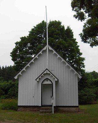
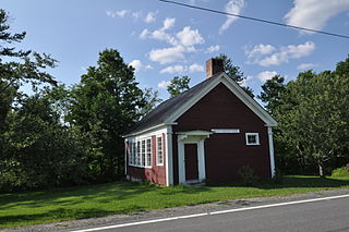
The Pine Grove Historic District encompasses a well-preserved collection of primarily 19th-century farmsteads, located near one another and a local district school building in Avon, Connecticut. Centered around the junction of West Avon and Harris Roads are four 19th-century farmsteads, one dating to the 18th century, and the 1865 Gothic Revival Pine Grove School. The district was listed on the National Register of Historic Places in 1980.

Guilford Historic Town Center is a large historic district encompassing the entire town center of Guilford, Connecticut, United States. It is centered on the town green, laid out in 1639, and extends north to Interstate 95, south to Long Island Sound, west to the West River, and east to East Creek. It includes more than 600 historic structures, most built between the late 17th and early 20th centuries, reflecting the town's growth and history during that time. It was listed on the National Register of Historic Places in 1976.

The Route 146 Historic District encompasses a historic streetscape in Branford and Guilford, Connecticut. Extending along Connecticut Route 146 between Flat Rock Road in Branford and the West River bridge in Guilford, it includes two centuries of rural residential architecture, and a well-preserved pre-World War II street layout created as a "state assistance road" in the 1920s. The district was listed on the National Register of Historic Places in 1990.


