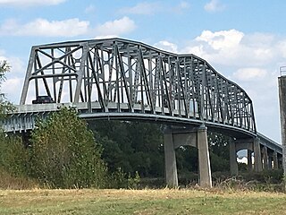
The Brownville Bridge is a truss bridge over the Missouri River on U.S. Route 136 (US 136) from Nemaha County, Nebraska, to Atchison County, Missouri, at Brownville, Nebraska.

The Casselman Bridge is a historic transportation structure on the Casselman River, located immediately east of Grantsville in Garrett County, Maryland, and preserved by the state of Maryland as Casselman River Bridge State Park. The bridge was built in 1813–1814 as part of the National Road. Historic markers posted at each end read:
Erected 1813 by David Shriver Jr.,
Sup't of the "Cumberland Road". This 80 foot span
was the largest stone arch in America
at the time. It was continuously
used from 1813 to 1933.
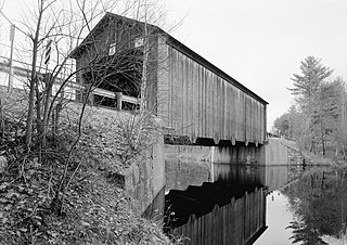
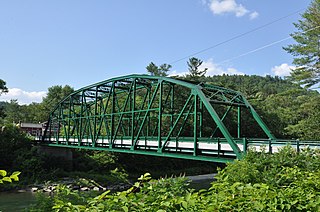
The Hancock–Greenfield Bridge is a historic covered bridge carrying Forest Road over the Contoocook River at the town line between Hancock and Greenfield, New Hampshire. The New Hampshire Department of Transportation covered bridge database refers to it as County Bridge. Built in 1937, it is the first wooden covered bridge in the northeastern United States to use modern engineering techniques. The bridge was listed on the National Register of Historic Places in 1981.
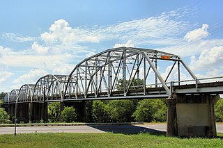
The Montopolis Bridge is a historic Parker through truss bridge in Austin, Texas. It is located in the Montopolis neighborhood where a bicycle and pedestrian walkway crosses the Colorado River in southeastern Travis County. The bridge consists of five 200-foot Parker through truss spans and four 52-foot steel I-beam approach spans resting on reinforced concrete abutments. It was added to the National Register of Historic Places on October 10, 1996. The Montopolis Bridge sits at the best crossing of the Colorado River in the area with the historic crossing of the El Camino Real de los Tejas National Historic Trail just to the east.
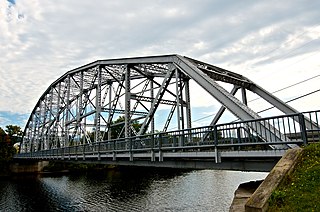
The Piermont Bridge carries New Hampshire Route 25 over the Connecticut River to the contiguous Vermont Route 25 between Piermont, New Hampshire and Bradford, Vermont. It is a Pennsylvania steel through truss bridge, built by the Boston Bridge Works in 1928. The bridge consists of a single span with a clear span of 352' and an overall length of 354'10". The roadbed is 20'7" wide, with a vertical clearance of 14'7". The bridge is approximately 25' above the river. The western (Vermont) abutment is made of split granite quarried from nearby Fairlee Mountain, while the eastern abutment is an early concrete construction built in 1908 by John Storrs for an earlier bridge. The bridge underwent a major renovation in 1993 which included the addition of a sidewalk and replacement of much of the bridge decking.

The South Newfane Bridge is a historic bridge, carrying Parish Hill Road across the Rock River in the village of South Newfane, Vermont. It is a Pratt through truss span, manufactured from rolled I-beams in 1939 to replace a bridge washed away in flooding. It was listed on the National Register of Historic Places in 1992.

The Cold River Bridge was a historic bridge that carried Vermont Route 7B (VT 7B) across the Cold River in Clarendon, Vermont. The bridge, a steel Parker through truss, was built by the American Bridge Company in 1928, and was one of many bridges built in the state in the wake of devastating 1927 floods. It carried U.S. Route 7 (US 7) until bypassed by a bridge to the east, and was closed in 1989. It was listed on the National Register of Historic Places in 1991. It was subsequently demolished after a report noting substantial failures.
Yellow Smoke Park Bridge is located on the eastern edge of Denison, Iowa, United States. Steel was in short supply during World War II as a part of the war effort. Many bridges built across the state were built in this era with timber, especially small-scale bridges. Heavy flooding washed out 27 bridges and culverts in Crawford County in May 1945. The county board of supervisors used emergency funds to build new bridges. They bought several steel superstructures from the Des Moines Steel Company to replace the washed-out spans. The bowstring arch-truss structures appear to have been designed by H. Gene McKeown, a civil engineer from Council Bluffs. This bridge is one several similar structures built in the county, and one of five that still remain. It was moved to serve a pedestrian path in a county park around 1986. The bridge was listed on the National Register of Historic Places in 1998.

The Nishnabotna River Bridge is located northeast of Manilla, Iowa, United States. It carries traffic on T Avenue over the Nishnabotna River. Steel was in short supply during World War II as a part of the war effort. Many bridges built across the state were built in this era with timber, especially small-scale bridges. Heavy flooding washed out 27 bridges and culverts in Crawford County in May 1945. The county board of supervisors used emergency funds to build new bridges. They bought several steel superstructures from the Des Moines Steel Company to replace the wash-out spans. The bowstring arch-truss structures appear to have been designed by H. Gene McKeown, a civil engineer from Council Bluffs. This bridge is one several similar structures built in the county, and one of five that still remain. The bridge was listed on the National Register of Historic Places in 1998.

The Nishnabotna River Bridge is located southwest of Manilla, Iowa, United States. It carries traffic on 310th Street over the Nishnabotna River. Steel was in short supply during World War II as a part of the war effort. Many bridges built across the state were built in this era with timber, especially small-scale bridges. Heavy flooding washed out 27 bridges and culverts in Crawford County in May 1945. The county board of supervisors used emergency funds to build new bridges. They bought several steel superstructures from the Des Moines Steel Company to replace the wash-out spans. The bowstring arch-truss structures appear to have been designed by H. Gene McKeown, a civil engineer from Council Bluffs. This bridge is one several similar structures built in the county, and one of five that still remain. The bridge was listed on the National Register of Historic Places in 1999.
The Beaver Creek Bridge was located northwest of Schleswig, Iowa, United States. It spanned Beaver Creek for 134 feet (41 m). Steel was in short supply during World War II as a part of the war effort. Many bridges built across the state were built in this era with timber, especially small-scale bridges. Heavy flooding washed out 27 bridges and culverts in Crawford County in May 1945. The county board of supervisors used emergency funds to build new bridges. They bought several steel superstructures from the Des Moines Steel Company to replace the wash-out spans. The bowstring arch-truss structures appear to have been designed by H. Gene McKeown, a civil engineer from Council Bluffs. This bridge was one of several similar structures built in the county. The bridge was listed on the National Register of Historic Places in 1998, and it was delisted in 2020.
The Buck Grove Bridge is located southeast of Buck Grove, Iowa, United States. It spans Buck Creek for 70 feet (21 m). Steel was in short supply during World War II as a part of the war effort. Many bridges built across the state were built in this era with timber, especially small-scale bridges. Heavy flooding washed out 27 bridges and culverts in Crawford County in May 1945. The county board of supervisors used emergency funds to build new bridges. They bought several steel superstructures from the Des Moines Steel Company to replace the wash-out spans. The bowstring arch-truss structures appear to have been designed by H. Gene McKeown, a civil engineer from Council Bluffs. This bridge is one several similar structures built in the county, and one of five that still remain. The bridge was listed on the National Register of Historic Places in 1998.
The Eisenhower Bridge is located east of Milton, Iowa, United States. It carries traffic on 252nd Street over the Fox River for 197 feet (60 m). The supervisors from Des Moines and Lee counties met on September 7, 1887, to view the location of a new bridge between the two counties over the Skunk River on the Burlington-Fort Madison Road. Financing delayed building the new bridge. They determined that Des Moines County would pay three-fifths of the costs and Lee County the remainder. Chicago engineer Horace B. Horton designed the Pratt truss, and it was built by the James B. Diver Bridge Company of Keokuk, Iowa. The Walker's Ferry Bridge was originally a two-span structure, and it was completed for $9,435. It was replaced with another bridge in 1930, and one of the spans was relocated to this location. Known locally as the Eisenhower Bridge, it replaced an 1895 span that was washed out in a flood. While it lost some of its historical integrity, it remains an example of early wagon bridge construction. It is also one of the few iron truss bridges remaining in Iowa, and it was designed by a prominent bridge engineer. The bridge was listed on the National Register of Historic Places in 1998.
Bridge 15, also known locally as the River Bridge, spans the White River in Sharon, Vermont. Built in 1928, this multi-span Parker truss bridge is one of a shrinking number of White River crossings of this type. It was listed on the National Register of Historic Places in 2008.

The Gould's Mill Bridge is a historic Baltimore through truss bridge, carrying Paddock Street across the Black River in Springfield, Vermont. The bridge was built by the Boston Bridge Works Company in 1929 after major flooding in 1927, and is one of the state's few examples of a Baltimore truss. It was listed on the National Register of Historic Places in 2006.

The Ottauquechee River Bridge is a steel girder bridge carrying United States Route 5 across the Ottauquechee River in Hartland, Vermont. The bridge replaced a c. 1930 Warren deck truss bridge, built in the wake of Vermont's devastating 1927 floods, and listed on the National Register of Historic Places in 1990.

The West Hartford Bridge is a steel deck girder bridge carrying Town Highway 14 across the White River in the village of West Hartford, Vermont. It was built by the town with state assistance in 2006, replacing a Parker through truss bridge built by the state after Vermont's devastating 1927 floods. The 1929 bridge was listed on the National Register of Historic Places in 1992.

The Winooski Street Bridge is a historic bridge carrying Winooski Street across the Winooski River between Duxbury and Waterbury, Vermont. Built in 1928, it is a Parker through truss, one of only two of this type on the Winooski River and an increasingly rare bridge type in the state. It was listed on the National Register of Historic Places in 2006 as Bridge 31.

Bridge 12 is a historic Parker through truss bridge, carrying Boston Post Road across the Missisquoi River in Enosburg, Vermont. Built in 1929 in the wake of Vermont's devastating 1927 floods, it is one a shrinking number of surviving truss bridges on the river. It was listed on the National Register of Historic Places in 2007.

The Burwell Bridge was a historic bridge on the northern edge of Burwell in Garfield County, Nebraska which was built in 1940–41. It was a steel girder bridge that brings Nebraska Highway 11 over the North Loup River. It is also known as the North Loup River Bridge and denoted as NEHBS Number GFOO-13. It was listed on the National Register of Historic Places in 1992, and was delisted in 2019.


