
The Uhlerstown–Frenchtown Bridge is a free bridge over the Delaware River, owned and operated by the Delaware River Joint Toll Bridge Commission. The bridge connects New Jersey Route 12 in Frenchtown of Hunterdon County, New Jersey with Pennsylvania Route 32 in Uhlerstown of Bucks County, Pennsylvania.
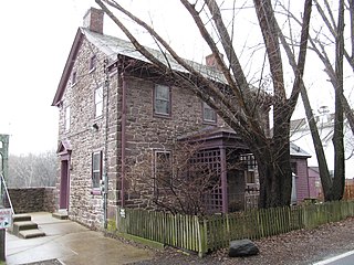
Lumberville is a village on the Delaware River in Solebury Township, Bucks County, Pennsylvania, United States, with a ZIP code of 18933. It is located seven miles north of New Hope, and is located along River Road.

The McMillin Bridge is a concrete half-through truss bridge crossing the Puyallup River, in Pierce County, Washington, built in 1934.
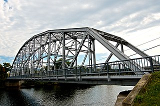
The Piermont Bridge carries New Hampshire Route 25 over the Connecticut River between Piermont, New Hampshire and Bradford, Vermont. It is a Pennsylvania steel through truss bridge, built by the Boston Bridge Works in 1928. The bridge consists of a single span with a clear span of 352' and an overall length of 354'10". The roadbed is 20'7" wide, with a vertical clearance of 14'7". The bridge is approximately 25' above the river. The western (Vermont) abutment is made of split granite quarried from nearby Fairlee Mountain, while the eastern abutment is an early concrete construction built in 1908 by John Storrs for an earlier bridge. The bridge underwent a major renovation in 1993 which included the addition of a sidewalk and replacement of much of the bridge decking.

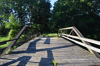
The Brookline-Newfane Bridge is a historic bridge spanning the West River between Brookline and Newfane, Vermont on Grassy Brook Road. It is a camelback through truss bridge, built in 1928 by the Berlin Construction Company in the wake of Vermont's devastating 1927 floods. The bridge was listed on the National Register of Historic Places in 2007 as Bridge 19, at which time it was one of seven surviving camelback bridges in the state. It last underwent a major rehabilitation in 2003-4.

The Follett Stone Arch Bridge Historic District encompasses a group of four stone arch bridges in southwestern Townshend, Vermont. All four bridges were built by James Otis Follett, a local self-taught mason, between 1894 and 1910, and represent the single greatest concentration of surviving bridges he built. The district was listed on the National Register of Historic Places in 1976.
County Line Bridge is a historic structure located in a rural area west of Columbus Junction, Iowa, United States. The Louisa County Board of Supervisors approved the petition of Thomas Anwyl in April 1893 to build a bridge over Long Creek on the Louisa-Washington county line. They awarded a $1,174 contract to the Gillette-Herzog Manufacturing Company of Minneapolis to build two bridges. The second span was the Gipple's Quarry Bridge over Buffington Creek in Elm Grove Township. The bridge span is supported by cast iron columns that were manufactured by the Cast Iron Pile and Bridge Company of Keosauqua, Iowa. The steel components were rolled by Carnegie, Gillette-Herzog in Pittsburgh. The pony truss bridge is typical of those built in the same era in Iowa, however, like Gipple's Quarry Bridge it has an unusual lower chord configuration with end panels that slope downward from the bearing shoes to the center panels. It has subsequently been abandoned. The bridge was listed on the National Register of Historic Places in 1998.

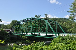
The South Newfane Bridge is a historic bridge, carrying Parish Hill Road across the Rock River in the village of South Newfane, Vermont. It is a Pratt through truss span, manufactured from rolled I-beams in 1939 to replace a bridge washed away in flooding. It was listed on the National Register of Historic Places in 1992.
Yellow Smoke Park Bridge is located on the eastern edge of Denison, Iowa, United States. Steel was in short supply during World War II as a part of the war effort. Many bridges built across the state were built in this era with timber, especially small-scale bridges. Heavy flooding washed out 27 bridges and culverts in Crawford County in May 1945. The county board of supervisors used emergency funds to build new bridges. They bought several steel superstructures from the Des Moines Steel Company to replace the washed-out spans. The bowstring arch-truss structures appear to have been designed by H. Gene McKeown, a civil engineer from Council Bluffs. This bridge is one several similar structures built in the county, and one of five that still remain. It was moved to serve a pedestrian path in a county park around 1986. The bridge was listed on the National Register of Historic Places in 1998.
The Nishnabotna River Bridge is located northeast of Manilla, Iowa, United States. It carries traffic on T Avenue over the Nishnabotna River. Steel was in short supply during World War II as a part of the war effort. Many bridges built across the state were built in this era with timber, especially small-scale bridges. Heavy flooding washed out 27 bridges and culverts in Crawford County in May 1945. The county board of supervisors used emergency funds to build new bridges. They bought several steel superstructures from the Des Moines Steel Company to replace the wash-out spans. The bowstring arch-truss structures appear to have been designed by H. Gene McKeown, a civil engineer from Council Bluffs. This bridge is one several similar structures built in the county, and one of five that still remain. The bridge was listed on the National Register of Historic Places in 1998.

The Nishnabotna River Bridge is located southwest of Manilla, Iowa, United States. It carries traffic on 310th Street over the Nishnabotna River. Steel was in short supply during World War II as a part of the war effort. Many bridges built across the state were built in this era with timber, especially small-scale bridges. Heavy flooding washed out 27 bridges and culverts in Crawford County in May 1945. The county board of supervisors used emergency funds to build new bridges. They bought several steel superstructures from the Des Moines Steel Company to replace the wash-out spans. The bowstring arch-truss structures appear to have been designed by H. Gene McKeown, a civil engineer from Council Bluffs. This bridge is one several similar structures built in the county, and one of five that still remain. The bridge was listed on the National Register of Historic Places in 1999.
The Beaver Creek Bridge was located northwest of Schleswig, Iowa, United States. It spanned Beaver Creek for 134 feet (41 m). Steel was in short supply during World War II as a part of the war effort. Many bridges built across the state were built in this era with timber, especially small-scale bridges. Heavy flooding washed out 27 bridges and culverts in Crawford County in May 1945. The county board of supervisors used emergency funds to build new bridges. They bought several steel superstructures from the Des Moines Steel Company to replace the wash-out spans. The bowstring arch-truss structures appear to have been designed by H. Gene McKeown, a civil engineer from Council Bluffs. This bridge was one of several similar structures built in the county. The bridge was listed on the National Register of Historic Places in 1998, and it was delisted in 2020.
The East Soldier River Bridge was located southwest of Charter Oak, Iowa, United States. It carried traffic on 120th Street over the East Soldier River. Steel was in short supply during World War II as a part of the war effort. Many bridges built across the state were built in this era with timber, especially small-scale bridges. Heavy flooding washed out 27 bridges and culverts in Crawford County in May 1945. The county board of supervisors used emergency funds to build new bridges. They bought several steel superstructures from the Des Moines Steel Company to replace the wash-out spans. The bowstring arch-truss structures appear to have been designed by H. Gene McKeown, a civil engineer from Council Bluffs. This bridge is one of several similar structures built in the county. The bridge was listed on the National Register of Historic Places in 1998, and it was delisted in 2020.
The Cove Creek Bridge was a historic bridge in rural eastern Conway County, Arkansas. It carried Arkansas Highway 124 across Cove Creek, just west of the hamlet of Martinsville, and west of the city of Twin Groves. It was a three-span steel structure with a total length of 267 feet (81 m). The main span was a Pratt through truss 101 feet (31 m), mounted on concrete piers, while the approach spans on either end were smaller pony trusses each 83 feet (25 m) long. The bridge was built in 1957, and was the one of few Pratt truss bridges in the state.
The Petit Jean River Bridge is a historic bridge in rural southern Logan County, Arkansas. The bridge carries Old Highway 109 across the Petit Jean River between Sugar Grove and Magazine. It consists of a single-span steel Pratt through truss and two masonry approach spans, set on concrete piers in the river. The total structure length is 273 feet (83 m), with a roadway width of 19 feet (5.8 m) and a total width of 24 feet (7.3 m). The bridge was built in 1938.
Bridge 15, also known locally as the River Bridge, spans the White River in Sharon, Vermont. Built in 1928, this multi-span Parker truss bridge is one of a shrinking number of White River crossings of this type. It was listed on the National Register of Historic Places in 2008.

The Gould's Mill Bridge is a historic Baltimore through truss bridge, carrying Paddock Street across the Black River in Springfield, Vermont. The bridge was built by the Boston Bridge Works Company in 1929 after major flooding in 1927, and is one of the state's few examples of a Baltimore truss. It was listed on the National Register of Historic Places in 2006.

The Quechee Gorge Bridge is a historic bridge, carrying U.S. Route 4 (US 4) across Quechee Gorge, near the Quechee village of Hartford, Vermont. Built in 1911, it is Vermont's oldest surviving steel arch bridge. It was listed on the National Register of Historic Places in 1990.

The West Hartford Bridge is a steel deck girder bridge carrying Town Highway 14 across the White River in the village of West Hartford, Vermont. It was built by the town with state assistance in 2006, replacing a Parker through truss bridge built by the state after Vermont's devastating 1927 floods. The 1929 bridge was listed on the National Register of Historic Places in 1992.

The Burwell Bridge was a historic bridge on the northern edge of Burwell in Garfield County, Nebraska which was built in 1940–41. It was a steel girder bridge that brings Nebraska Highway 11 over the North Loup River. It is also known as the North Loup River Bridge and denoted as NEHBS Number GFOO-13. It was listed on the National Register of Historic Places in 1992, and was delisted in 2019.


