El Rey archaeological site

Last updated
Structure 22.1 (the columned temple) at El Rey. El Rey archaeological site.jpg
Structure 22.1 (the columned temple) at El Rey.

El Rey is an archaeological site of the pre-Columbian Mayan culture, located in the southeast of Mexico, in the tourist resort of Cancun, in the state of Quintana Roo.

Contents

Geography

The El Rey site is located on the Mexican coast of the Caribbean Sea, in the hotel zone of the island of Cancun. The island is located on the outskirts of the city centre and is connected by two bridges to the mainland.

The original name in the Mayan language is not known. In 1909 two English travelers Channing Arnold and Frederick Frost visited the site and found an anthropomorphic sculpture of what was interpreted as a monarch or a noble person. [1] The name El Rey ("the king") comes from a sculpture that resembles a monarch, [2] the head of which is preserved in the Archaeological Museum of Cancun. [3]

History

The site reached its housing peak probably in the early classical period (250-600 AD). The first settlers built houses on platforms, although the organic materials used have not been preserved over the centuries.

Between the years 200 and 1200 AD. the inhabitants of the site worked as fishermen and in salt extraction.

In a later period the site gained importance because immigrants arrived from the interior of the Yucatan Peninsula, approximately between 1300 and 1500 AD. The structures that can currently be seen date from then.

Within the coastal commercial network El Rey was one of the ports on the Caribbean coast. Other important ports in the south were Xcaret, Xelha, Tulum, and Muyil.

After the arrival of the Spaniards in the sixteenth century, the site was abandoned by the Mayans.

Archaeology

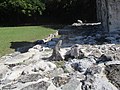
El Rey is the most important archaeological site on the island of Cancun. It is made up of 47 structures of varying functions. Archaeologists have found remains of mural paintings and drawings dating from the post-classical period.

During the excavation of a temple in 1975, archaeologists found the burial site of a person of high rank, with a copper axe, a bracelet, and ornaments of shell and bone.

Related Research Articles

The Huastec or Téenek are an indigenous people of Mexico, living in the La Huasteca region including the states of Hidalgo, Veracruz, San Luis Potosí and Tamaulipas concentrated along the route of the Pánuco River and along the coast of the Gulf of Mexico.

<span class="mw-page-title-main">Coba</span> Pre-Columbian Maya site in the northeastern Yucatán peninsula

Coba is an ancient Maya city on the Yucatán Peninsula, located in the Mexican state of Quintana Roo. The site is the nexus of the largest network of stone causeways of the ancient Maya world, and it contains many engraved and sculpted stelae that document ceremonial life and important events of the Late Classic Period of Mesoamerican civilization. The adjacent modern village bearing the same name, reported a population of 1,278 inhabitants in the 2010 Mexican federal census.

<span class="mw-page-title-main">Nim Li Punit</span>

Nim Li Punit is a Maya Classic Period site in the Toledo District of the nation of Belize, located 50 kilometres north of the town of Punta Gorda, and directly adjacent to the village of Indian Creek. Nim Li Punit is sometimes known as Big Hat or Top Hat; the name is Kekchi Maya for "Big Hat", referring to the large elaborate head-dress on a stela sculpture found on site depicting one of the site's ancient kings. It is bordered by the Maya Mountains to the west and lowland swamps and the Caribbean Sea to the east.

<span class="mw-page-title-main">Cancún</span> City in Quintana Roo, Mexico

Cancún, often Cancun in English is a city in southeast Mexico on the northeast coast of the Yucatán Peninsula in the Mexican state of Quintana Roo. It is a significant tourist destination in Mexico and the seat of the municipality of Benito Juárez. The city is on the Caribbean Sea and is one of Mexico's easternmost points.

<span class="mw-page-title-main">Tulum</span> Maya site in Quintana Roo, Mexico

Tulum is the site of a pre-Columbian Mayan walled city which served as a major port for Coba, in the Mexican state of Quintana Roo. The ruins are situated on 12-meter-tall (39 ft) cliffs along the east coast of the Yucatán Peninsula on the Caribbean Sea. Tulum was one of the last cities built and inhabited by the Maya and achieved its greatest prominence between the 13th and 15th centuries. Maya continued to occupy Tulum for about 70 years after the Spanish began occupying Mexico, but the city was abandoned by the end of the 16th century. Tulum is one of the best-preserved coastal Maya sites, and today a popular site for tourists.

<span class="mw-page-title-main">Naranjo</span>

Naranjo is a Pre-Columbian Maya city in the Petén Basin region of Guatemala. It was occupied from about 500 BC to 950 AD, with its height in the Late Classic Period. The site is part of Yaxha-Nakum-Naranjo National Park. The city lies along the Mopan and Holmul rivers, and is about 50 km east of the site of Tikal. Naranjo has been the victim of severe looting. The site is known for its polychrome ceramic style

<span class="mw-page-title-main">El Castillo, Chichen Itza</span> Step pyramid in the Mayan city of Chichen Itza in Tinúm, Mexico

El templo, known as the Temple of Kukulcán, is a Mesoamerican step-pyramid that dominates the center of the Chichen Itza archaeological site in the Mexican state of Yucatán. The temple building is more formally designated by archaeologists as Chichen Itza Structure 5B18.

<span class="mw-page-title-main">Costa Maya</span>

Costa Maya is a small tourist region in the municipality of Othón P. Blanco in the state of Quintana Roo, Mexico, the only state bounded by the Caribbean Sea to its east. This municipality is close to Chetumal on the border with Belize. The area was generally undeveloped but has been growing rapidly since construction of a large pier to accommodate cruise ships. Costa Maya is also the name of a subdivision near the village of Mahahual. The beach extends from Xcalak in the south to the southern border of Sian Ka'an in the north, a distance of approximately 100 kilometers (62 mi).

<span class="mw-page-title-main">San Gervasio (Maya site)</span>

San Gervasio is an archaeological site of the pre-Columbian Maya civilization, located in the northern third of the island of Cozumel off the northeastern coast of the Yucatán Peninsula, in what is now the Mexican state of Quintana Roo. San Gervasio's pre-Hispanic name was Tantun Cuzamil, Mayan for Flat Rock in the place of the Swallows. The ruins were once a hub of worship of the goddess Ix Chel, an aged deity of childbirth, fertility, medicine, and weaving. Pre-Columbian Maya women would try to travel to San Gervasio and make offerings at least once in their lives. In 1560, the Spanish historian, Diego Lopez de Cogolludo, wrote: "The pilgrims arrive at Cozumel for the fulfillment of their vows to offer their sacrifices, to ask help for their needs, and for the mistaken adoration of their false gods." The bishop of Yucatán, Diego de Landa, wrote in 1549 that the Maya "held Cozumel in the same veneration as we have for pilgrimages to Jerusalem and Rome, and so they used to go to visit and offer presents there, as we do to holy places; and if they did not go themselves, they always sent their offerings."

<span class="mw-page-title-main">Xcaret</span> Maya civilization archaeological site

Xcaret is a Maya civilization archaeological site located on the Caribbean coastline of the Yucatán Peninsula, in the state of Quintana Roo in Mexico. The site was occupied by the pre-Columbian Maya and functioned as a port for navigation and an important Maya trading center. Some of the site's original structures are contained within a modern-day tourism development, the privately owned Xcaret Park.

<span class="mw-page-title-main">Chicanná</span> Ancient Mayan town

Chicanná was a Maya town that was built during the Classic period. The site was named after its most famous building, Structure II, which means "House of the Serpent Mouth" in Mayan. In the Mayan language chi means "mouth", can means "serpent" and na means "house". The site is located two kilometers west of Becán in the Mexican state of Campeche on the Yucatán peninsula. It is one of 45 other ruin sites located within that area.

<span class="mw-page-title-main">Pre-Columbian Belize</span> Belize prior to Spanish colonisation

The Pre-Columbian Belize history is the period from initial indigenous presence, across millennia, to the first contacts with Europeans - the Pre-Columbian or before Columbus period - that occurred on the region of the Yucatán Peninsula that is present day Belize.

<span class="mw-page-title-main">Painting in the Americas before European colonization</span>

Painting in the Americas before European colonization is the Precolumbian painting traditions of the Americas. Painting was a relatively widespread, popular and diverse means of communication and expression for both religious and utilitarian purpose throughout the regions of the Western Hemisphere. During the period before and after European exploration and settlement of the Americas; including North America, Central America, South America and the islands of the Caribbean, the Bahamas, the West Indies, the Antilles, the Lesser Antilles and other island groups, indigenous native cultures produced a wide variety of visual arts, including painting on textiles, hides, rock and cave surfaces, bodies especially faces, ceramics, architectural features including interior murals, wood panels, and other available surfaces. Many of the perishable surfaces, such as woven textiles, typically have not been preserved, but Precolumbian painting on ceramics, walls, and rocks have survived more frequently.

<span class="mw-page-title-main">Muyil</span>

Muyil was one of the earliest and longest inhabited ancient Maya sites on the eastern coast of the Yucatan Peninsula. It is located approximately 15 kilometres (9.3 mi) south of the coastal site of Tulum, in the Municipality of Felipe Carrillo Puerto in the state of Quintana Roo, Mexico. Artifacts found here date back from as early as 350 BC. to as late as 1200-1500 AD. The ruins of Muyil are an example of Peten architecture, like those found in southern Mayan sites with their steep walled pyramids such as Tikal in Guatemala. It is situated on the Sian Ka'an lagoon, a name meaning "Where the Sky is Born". Muyil was located along a trade route on the Caribbean once accessible via a series of canals. Among the most commonly traded goods were Jade, obsidian, chocolate, honey, feathers, chewing gum, and salt. It is believed that throughout much of its history, Muyil had strong ties to the center of Coba located some 44 kilometres (27 mi) the north / northwest. The 2010 federal census reported a population of 191 inhabitants in the locality.

<span class="mw-page-title-main">Chactún</span> Archaeological site in Mexico

Chactún is the name of an archaeological site of the Mesoamerican Maya civilization in the state of Campeche, Mexico, in the northern part of the Calakmul Biosphere Reserve. The site of approximately 54 acres (22 ha) is located in the lowlands of the Yucatán Peninsula, between the regions of Rio Bec and Chenes. There are some significant differences that have yet to be explained completely, which distinguish it from some of the other nearby sites.

<span class="mw-page-title-main">El Zapotal</span>

El Zapotal is a Totonac archaeological site located in the Ignacio de la Llave Municipality in Veracruz, Mexico. It contains the ruins of a Totonac city that flourished from 600 to 900 CE, during what archaeologists call the Classical Period.

<span class="mw-page-title-main">Maritime trade in the Maya civilization</span>

The extensive trade networks of the Ancient Maya contributed largely to the success of their civilization spanning three millennia. The Maya royals control and wide distribution of foreign and domestic commodities for both population sustenance and social affluence are hallmarks of the Maya visible throughout much of the iconography found in the archaeological record. In particular, moderately long distance trade of foreign commodities from the Caribbean and Gulf Coasts provided the larger inland Maya cities with the resources they needed to sustain settled population levels in the several thousands. Though the ruling class essentially controlled the trade economy, a middle merchant class supervised import and export from cities and trade ports. Not much is known of the Maya merchant class; however, merchants of royal lineage are sometimes represented in the iconography. Notably, a canoe paddle often accompanies the royal merchant depictions, signifying their association with marine resources.

<span class="mw-page-title-main">Tourism in Honduras</span>

Honduras is a touristic destination that attracts visitors due to its natural environment, white and dark sand beaches, coral reefs, abundant flora and fauna, colonial era towns, and archaeological sites. Other attractions include the area's customs and traditional foods. In 2019 Honduras received 2.8 million foreigners, half of those tourists are cruise passengers.

<span class="mw-page-title-main">Pre-Columbian Honduras</span>

The territory of current Honduras was inhabited by two culturally distinct peoples: the Maya civilization and the Nahua. Although the Mesoamerican influence was the one that remained as the dominant influence in the territory.

<span class="mw-page-title-main">Rio Amarillo (Mayan Site)</span>

Rio Amarillo also known as La Castellona or La Canteada, is an archaeological site of the Mayan civilization located in the department of Copan in Honduras that dates back to the Mesoamerican classical period. The structures found reveal that it was a city of big size and that functioned as a point of passage for Mayan travelers during their journeys, although it also shows the decline of the Mayan Civilization and it was the last Mayan city in Honduran soil to be abandoned by the end of the classic period.

References

  1. "El Rey". "Mexican Routes [mexicanroutes.com]".
  2. "El Rey :: Mundo Maya Official Web Site". mundomaya.travel. Retrieved 2018-06-16.
  3. "El Rey". Hammocks & Ruins. Retrieved 2018-06-16.

Coordinates: 21°03′40″N86°46′53″W / 21.0611°N 86.7815°W / 21.0611; -86.7815