Elberta, Pennsylvania

Last updated

Elberta, Pennsylvania
USA Pennsylvania location map.svg
Red pog.svg
Elberta
Usa edcp location map.svg
Red pog.svg
Elberta
Coordinates: 40°30′45″N78°19′27″W / 40.51250°N 78.32417°W / 40.51250; -78.32417
CountryUnited States
State Pennsylvania
County Blair
Township Tyrone
Area
[1]
  Total0.63 sq mi (1.63 km2)
  Land0.63 sq mi (1.63 km2)
  Water0.00 sq mi (0.00 km2)
Elevation
[2]
1,765 ft (538 m)
Population
 (2020) [3]
  Total271
  Density430.84/sq mi (166.46/km2)
Time zone UTC-5 (Eastern (EST))
  Summer (DST) UTC-4 (EDT)
ZIP Code
16601 (Altoona)
Area code(s) 814/582
FIPS code 42-22776
GNIS feature ID2805492 [2]

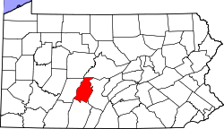
Elberta is an unincorporated community and census-designated place (CDP) in Blair County, Pennsylvania, United States. It was first listed as a CDP prior to the 2020 census. [2]

Contents

Geography

The CDP is in central Blair County, in the southern end of Tyrone Township. It is at the headwaters of Sinking Run, in a valley between two arms of Brush Mountain. Sinking Run flows northeast into Sinking Valley and joins the Little Juniata River at the northeastern end of Tyrone Township.

Kettle Road is the only through road in Elberta. It leads west through the Kettle Creek water gap in Brush Mountain 4 miles (6 km) to Altoona, while to the northeast it leads 11 miles (18 km) through Sinking Valley to Pennsylvania Route 453.

Demographics

Historical population
CensusPop.Note
2020 271
U.S. Decennial Census [4]

Related Research Articles

<span class="mw-page-title-main">Tyrone Township, Blair County, Pennsylvania</span> Township in Pennsylvania, United States

Tyrone Township is a township in Blair County, Pennsylvania, United States. It is part of the Altoona, PA Metropolitan Statistical Area. The population was 1,873 at the 2020 census.

<span class="mw-page-title-main">Madisonburg, Pennsylvania</span> Census designated place in Pennsylvania, United States

Madisonburg is an unincorporated community and census-designated place (CDP) in Miles Township, Centre County, Pennsylvania, United States. It is part of the State College, Pennsylvania Metropolitan Statistical Area. The population was 168 at the 2010 census.

<span class="mw-page-title-main">Brush Mountain (Blair County, Pennsylvania)</span> Mountain in Blair County, Pennsylvania, United States

Brush Mountain is a stratigraphic ridge in the Appalachian Mountains of central Pennsylvania, United States, lying east of the Allegheny Front and west of Tussey Mountain. It runs along the southeast side of the Little Juniata River and forms a horseshoe around Sinking Run, and is the westernmost ridge in its section of the Ridge-and-valley Appalachians. The western ridge line separates the Logan Valley from the Sinking Valley.

<span class="mw-page-title-main">Nittany, Pennsylvania</span> Census designated place in Pennsylvania, United States

Nittany is an unincorporated community and census-designated place in Walker Township, Centre County, Pennsylvania, United States. As of the 2010 census, the population was 658.

Carson Valley is an unincorporated community and census-designated place (CDP) in Blair County, Pennsylvania, United States. It was first listed as a CDP prior to the 2020 census.

Charlottsville is an unincorporated community and census-designated place (CDP) in Blair County, Pennsylvania, United States. It was first listed as a CDP prior to the 2020 census.

<span class="mw-page-title-main">Geeseytown, Pennsylvania</span> Census-designated place in Pennsylvania, United States

Geeseytown is an unincorporated community and census-designated place (CDP) in Blair County, Pennsylvania, United States. It was first listed as a CDP prior to the 2020 census.

Ironville is an unincorporated community and census-designated place (CDP) in Blair County, Pennsylvania, United States. It was first listed as a CDP prior to the 2020 census.

Klahr is an unincorporated community and census-designated place (CDP) in Blair County, Pennsylvania, United States. It was first listed as a CDP prior to the 2020 census.

Moores Mill is a census-designated place (CDP) in Blair County, Pennsylvania, United States. It was first listed as a CDP prior to the 2020 census.

Nealmont is an unincorporated community and census-designated place (CDP) in Blair County, Pennsylvania, United States. It was first listed as a CDP prior to the 2020 census.

Olivia is an unincorporated community and census-designated place (CDP) in Blair County, Pennsylvania, United States. It was first listed as a CDP prior to the 2020 census.

Point View is an unincorporated community and census-designated place (CDP) in Blair County, Pennsylvania, United States. It was first listed as a CDP prior to the 2020 census.

Reservoir is an unincorporated community and census-designated place (CDP) in Blair County, Pennsylvania, United States. It was first listed as a CDP prior to the 2020 census.

Sickles Corner is an unincorporated community and census-designated place (CDP) in Blair County, Pennsylvania, United States. It was first listed as a CDP prior to the 2020 census.

Ski Gap is a census-designated place (CDP) in Blair County, Pennsylvania, United States. It was first listed as a CDP prior to the 2020 census. The CDP corresponds to the unincorporated community of Fredericksburg, not to be confused with the Fredericksburg in the eastern part of Blair County.

Tyrone Forge is an unincorporated community and census-designated place (CDP) in Blair County, Pennsylvania, United States. It was first listed as a CDP prior to the 2020 census.

Vail is an unincorporated community and census-designated place (CDP) in Blair County, Pennsylvania, United States. It was first listed as a CDP prior to the 2020 census.

Continental Courts is a mobile home park and census-designated place (CDP) in Centre County, Pennsylvania, United States. It was first listed as a CDP prior to the 2020 census.

Eagle Creek is a census-designated place (CDP) in Centre County, Pennsylvania, United States. It was first listed as a CDP prior to the 2020 census.

References

  1. "ArcGIS REST Services Directory". United States Census Bureau. Retrieved October 12, 2022.
  2. 1 2 3 U.S. Geological Survey Geographic Names Information System: Elberta, Pennsylvania
  3. "Census Population API". United States Census Bureau. Retrieved October 12, 2022.
  4. "Census of Population and Housing". Census.gov. Retrieved June 4, 2016.