
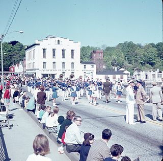
Fairfield is a town in Fairfield County, Connecticut, United States. It borders the city of Bridgeport and towns of Trumbull, Easton, Weston, and Westport along the Gold Coast of Connecticut. As of 2020, the town had a population of 61,512. The town is part of the Greater Bridgeport Planning Region.

The Worthington Ridge Historic District encompasses the historic town center of Berlin, Connecticut. It runs mostly along Worthington Ridge Road from the intersection of Mill Street to Sunset Lane. This section of road was historically part of the Boston Post Road laid out in 1673, and is now lined by a diversity of residential architecture and several of the town's civic buildings. In 1974, the Berlin Historic District was formed in order to preserve the integrity of the architecture of the village. The district was listed on the National Register of Historic Places in 1989.

The Brookfield Center Historic District in Brookfield, Connecticut is a historic district that was listed on the National Register of Historic Places in 1991. It is located in the vicinity of the junction of Route 133 and Route 25. The district represents the original settlement of the town of Brookfield and contains 67 residential, religious, and municipal buildings over a 43-acre (17 ha) area representing a wide range of architectural styles from the 18th to 20th centuries including Bungalow/Craftsman, Greek Revival, and Queen Anne style architecture. The district includes the old town hall, the Congregational Church of Brookfield, Saint Joseph Church & Elementary School, Center Elementary School (Public), the former general store, St. Paul's Episcopal Church, and the surrounding residential neighborhood. The district is architecturally significant as an accurate representation of the historical development of the original settlement of the Town of Brookfield as the buildings are well-preserved from the time they were built with minimal alterations and intrusions, including their spatial relationships to one another.

The Newtown Borough Historic District is a 100-acre (40 ha) historic district in the borough of Newtown in Newtown, Connecticut. There is a local historic district and an overlapping district that was listed on the National Register of Historic Places in 1996.

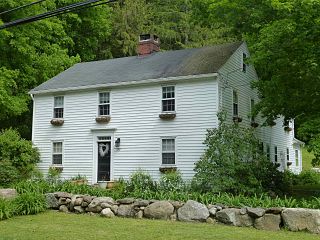
The Southport Historic District in the town of Fairfield, Connecticut is a 225-acre (91 ha) area historic district that was listed on the National Register of Historic Places in 1971. It preserves a portion of the modern neighborhood and former borough of Southport, Connecticut. Since the British burnt almost all of Southport's structures in 1779, there is only one home built prior to that date, the Meeker House at 824 Harbor Road, which survives.

The Wilton Center Historic District in the town center area of Wilton, Connecticut, was established as a town historic district in 1970 and was listed on the National Register of Historic Places in 1992.

Goshen Historic District is a historic district encompassing the town center village of Goshen, Connecticut. Centered at the junction of Connecticut Routes 4 and 63, the village developed historically as a rural crossroads of two turnpikes, and has retained its rural character. It is dominated by residential architecture from the first half of the 19th century, and includes churches, a store, and the town's former 1895 town hall. It was listed on the National Register of Historic Places in 1982.

Norwichtown is a historic neighborhood in the city of Norwich, Connecticut, United States. It is generally the area immediately north of the Yantic River between I-395 and Route 169.

The Greenwich Avenue Historic District is a historic district representing the commercial and civic historical development of the downtown area of the town of Greenwich, Connecticut. The district was listed on the National Register of Historic Places on August 31, 1989. Included in the district is the Greenwich Municipal Center Historic District, which was listed on the National Register the year before for the classical revival style municipal buildings in the core of Downtown. Most of the commercial buildings in the district fall into three broad styles, reflecting the period in which they were built: Italianate, Georgian Revival, and Commercial style. The district is linear and runs north–south along the entire length of Greenwich Avenue, the main thoroughfare of Downtown Greenwich, between U.S. Route 1 and the New Haven Line railroad tracks.

The Boston Post Road Historic District encompasses a cross-section of residential architectural styles representative of much of the history of Darien, Connecticut. Centered on the junction of Boston Post Road and Brookdale Road, the district also includes two civic landmarks: the town hall and the Greek Revival First Congregational Church. The district was listed on the National Register of Historic Places in 1982.

The Kettle Creek Historic District encompasses one of the earliest settlement areas of the town of Weston, Connecticut. It consists of a small crossroads village center, extending north from the junction of Weston Road and Broad Street to the junction with Old Weston Road, and includes a small number of well-preserved 18th and 19th-century houses. It was listed on the National Register of Historic Places in 1985.
The National Hall Historic District is a 3-acre (1.2 ha) historic district in Westport, Connecticut that was listed on the National Register of Historic Places in 1984. The district encompasses a historic commercial center of the town, located on the west bank of the Saugatuck River where the Boston Post Road crosses the river. It includes eleven historic structures, most of which historically had some sort of commercial function. There are a few residences, and one civic structure, the wood-frame Vigilante Fire House on Wilton Road. The centerpiece of the district is the large National Hall building, an 1873 three-story Italianate structure that visually dominates the junction of the Post Road with Wilton Road and Reservoir Road. The area's first period of development was in the early 19th century, a period from which five buildings survive.

The Putnam Hill Historic District encompasses a former town center of Greenwich, Connecticut. Located on United States Route 1 between Milbank Avenue and Old Church Road, the district includes the churches of two historic congregations, a former tavern, and a collection of fine mid-Victorian residential architecture. The district was listed on the National Register of Historic Places in 1979.
The Canton Center Historic District encompasses the historic rural town center of Canton, Connecticut, United States. Extending mainly along Connecticut Route 179, near the geographic town center, is a well-preserved example of a rural agricultural center in Connecticut, a role served until about 1920. The district includes many examples of Late Victorian and Greek Revival architecture. It was listed on the National Register of Historic Places in 1997.

Hebron Center Historic District encompasses most of the historic village center of Hebron, Connecticut. Centered on the junction of Connecticut Routes 66 and 85, it has served as the rural community's civic center since its incorporation in 1708. The district was listed on the National Register of Historic Places in 1993.

The Old Saybrook South Green is a 20-acre (8.1 ha) historic district that encompasses the historic town green and nearby streets in Old Saybrook, Connecticut. Established in the 1630s, most of the buildings arrayed around the green were built between 1760 and 1900, and reflect the prosperity of the town, which was a major port and shipbuilding center. The district was listed on the National Register of Historic Places in 1976.

The Canaan Street Historic District encompasses the historic original town center of Canaan, New Hampshire. It is a basically linear district, running along Canaan Street roughly from Prospect Hill Road in the north to Moss Flower Lane in the south. The town flourished first as a stagecoach stop, and then as a resort colony in the late 19th century. The historic district was listed on the National Register of Historic Places in 1973. It included 60 contributing buildings.

Barkhamsted Center Historic District is a historic district at the intersection of Center Hill Road and Old Town Hall Road in Barkhamsted, Connecticut. It encompasses the surviving elements of Barkhamsted's original town center, most of which was flooded by the creation of Barkhamsted Reservoir in the early 20th century. The district was listed on the National Register of Historic Places in 1999.

The Rocky Hill Center Historic District encompasses the traditional town center and surrounding residential area of Rocky Hill, Connecticut. It extends along Old Main Street from the Wethersfield line southward to a triangular area bounded by Old Main, Riverview Road, and Glastonbury Avenue. Included in a basically 19th-century streetscape are the town's principal civic and religious buildings, as well as a fine collection of mainly 18th and 19th-century residential architecture. The district was listed on the National Register of Historic Places in 2007.

The Salem Historic District encompasses the historic 19th-century town center of Salem, Connecticut. It extends along Connecticut Route 85 roughly from Round Hill Road to Music Vale Road, and includes the rural town's major civic and institutional buildings, as well as a number of surrounding residences. The area was developed after the town was incorporated in 1819, and was mostly built out by 1885. The district was listed on the National Register of Historic Places in 1980.


