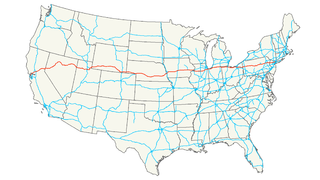
Interstate 80 (I-80) is an east–west transcontinental freeway in the United States that runs from downtown San Francisco, California, to Teaneck, New Jersey, in the New York City Metropolitan Area. The highway was designated in 1956 as one of the original routes of the Interstate Highway System. Its final segment was opened to traffic in 1986. It is the second-longest Interstate Highway in the United States, following I-90. The Interstate runs through many major cities including Oakland, Sacramento, Reno, Salt Lake City, Omaha, Des Moines, and Toledo, and passes within 10 miles (16 km) of Chicago, Cleveland, and New York City.

Indian Lake is a town in Hamilton County, New York, United States. The population was 1,352 at the 2010 census. The name is from a lake of the same name that is largely inside the town. There are no permanent stop lights in the town. Law enforcement is provided by New York State Troopers.

Wells is a town in Hamilton County, New York, United States. The population was 674 at the 2010 census. The town is named after Joshua Wells, a land agent, who built the first mills in the area. It is in the Adirondack Park and on the eastern border of the county. It is northwest of Schenectady.

Ohio is a town in Herkimer County, New York, United States. The population was 1,002 at the 2010 census. The town is named after the state of Ohio. The town is in the northern part of the county and northeast of Utica. Part of Ohio is within the Adirondack Park.

Northeast is the northeastern quadrant of Washington, D.C., the capital of the United States. It encompasses the area located north of East Capitol Street and east of North Capitol Street.

Hamilton Mountain is a federal electoral district in Ontario, Canada, that has been represented in the House of Commons of Canada since 1968. The riding is located in the Hamilton, Ontario region.

The Judaean Mountains, or Judaean Hills, is a mountain range in Israel and the West Bank where Jerusalem and several other biblical cities are located. The mountains reach a height of 1,026 metres (3,366 ft). The Judean Mountains can be separated to a number of sub-regions, including the Mount Hebron ridge, the Jerusalem ridge and the Judean slopes. These mountains formed the heartland of the Kingdom of Judah, where the earliest Jewish settlements emerged.

Lanfair Valley is located in the Mojave Desert in southeastern California near the Nevada state line. It is bounded on the north by the New York Mountains and Castle Mountains, on the east by the Piute Range, and on the south by the Woods Mountains and Vontrigger Hills. Joshua Trees can be found in most of the valley. Elevation is 4,045 feet.
Nippletop is a mountain located in Essex County, New York. The mountain is part of the Colvin Range. Nippletop is flanked to the northeast by Dial Mountain. To the east, it faces Dix Mountain across Hunters Pass, and to the west it faces Mount Colvin across Elk Pass.

Vly Mountain is a mountain located in the town of Halcott, New York, United States in Greene County. The mountain is part of the Catskill Mountains. Vly Mountain is flanked to the northwest by Bearpen Mountain, to the east by Vinegar Hill, to the northeast by Kipp Hill, and to the southeast by Beech Ridge.

The Kaiser Wilderness is a federally designated wilderness protected area located 70 miles (110 km) northeast of Fresno in the state of California, USA. It was added to the National Wilderness Preservation System by the United States Congress on October 19, 1976. The wilderness is 22,700 acres (92 km2) in size, is one of five wilderness areas within the Sierra National Forest and is managed by the US Forest Service.

The Piper Mountain Wilderness is a federally designated wilderness area located in the White Mountains 20 miles (32 km) northeast of Big Pine, California in Inyo County, California.

The Bullfrog Hills are a small mountain range of the Mojave Desert in southern Nye County, southwestern Nevada. Bullfrog Hills was so named from a fancied resemblance of its ore to the color of a bullfrog.

The Lenne Mountains, or Lenne Uplands (Lennebergland), is a range of hills up to 656 m above sea level (NN) high in the German state of North Rhine-Westphalia. It is part of the Süder Uplands within the Rhine Massif.

The Little Rincon Mountains are a small range of mountains, lying to the east of the Rincon Mountains, at Tucson, of eastern Pima County, Arizona. The range is located in northwest Cochise County and is part of the western border of the San Pedro River and Valley, the major valley and river of western Cochise County. The river is northward flowing to meet the Gila River; its headwaters are south of the US-Mexico border in northern Sonora. A small part of the Little Rincon range's southwest lies in Pima County.
The Black Hills of Greenlee County are a 20 mi (32 km) long mountain range of the extreme northeast Sonoran Desert bordering the south of the White Mountains of eastern Arizona's transition zone.
Boomhower Hill is a mountain located in the Catskill Mountains of New York northeast of Delhi. Federal Hill is located southwest and Bramley Mountain is located east of Boomhower Hill.
Red Hill is a mountain located in the Catskill Mountains of New York east-south of Frost Valley. Woodhull Mountain is located northeast of Red Hill.

Van Loan Hill is a mountain in Greene County, New York. It is located in the Catskill Mountains southwest of Maplecrest. Round Hill is located west, Elm Ridge is located north-northeast, and East Jewett Range is located south of Van Loan Hill.


