Niger is a landlocked nation in West Africa located along the border between the Sahara and Sub-Saharan regions. Its geographic coordinates are longitude 16°N and latitude 8°E. Its area is 1.267 million square kilometers, of which 1 266 700 km2 is land and 300 km2 water, making Niger slightly less than twice the size of France.

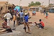
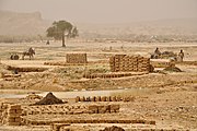
Niamey is the capital and largest city of Niger. Niamey lies on the Niger River, primarily situated on the east bank. Niamey's population was counted as 1,026,848 as of the 2012 census. As of 2017, population projections show the capital district growing at a slower rate than the country as a whole, which has the world's highest fertility rate. The city is located in a pearl millet growing region, while manufacturing industries include bricks, ceramic goods, cement, and weaving.

Zinder, formerly also spelled Sinder, is the third largest city in Niger, with a population of 235,605 as by the 2012 census. It is situated 861 km (535 mi) east of the capital Niamey and 240 km (150 mi) north of the Nigerian city of Kano.

Tchintabaraden is a town and commune located in the Azawagh area of Niger, in the north of the Tahoua Region. It is the capital of the region's Tchintabaraden Department. It is the market center for the Iwellemmedan Tuareg. The first insurrectionist movement for the autonomy of Tenere, the Tuareg region in central-north and western Niger, began here and in nearby Abalagh in 1985. In the neighboring oasis of In-Gall, the Cure Salee, or "the festival of the nomads", is held annually.

The regions of Niger are subdivided into 63 departments. Before the devolution program on 1999–2005, these departments were styled arrondissements. Confusingly, the next level up (regions) had, before 2002-2005 been styled departments. Prior to a revision in 2011, there had been 36 departments. Until 2010, arrondissements remained a proposed subdivision of departments, though none were used. The decentralisation process, begun in the 1995-1999 period replaced appointed Prefects at Departmental or Arrondissement level with elected councils, first elected in 1999. These were the first local elections held in the history of Niger. Officials elected at commune level are then selected as representatives at Departmental, regional, and National level councils and administration. The Ministry of Decentralisation was created to oversee this task, and to create a national consultative council of local officials.

Gao, or Gawgaw/Kawkaw, is a city in Mali and the capital of the Gao Region. The city is located on the River Niger, 320 km (200 mi) east-southeast of Timbuktu on the left bank at the junction with the Tilemsi valley.
Ayourou is a town and rural commune in the Tillabéri Region, in western Niger. It is situated 208 km northwest of the capital Niamey near the Malian border. The old town stands on an eponymous island in the River Niger. It is known for its animal market and for wildlife including hippopotamuses and birds.

Dakoro is a town and commune located in the Maradi Region of Niger. As of 2012, it had a population of 71,201. It is the capital of the Dakoro Department.

Madaoua is a town and urban commune located in the Tahoua Region of Niger. It has a population of 127,254. It is seat of the Madaoua Department, forming the southwest corner of the Region, and is an Urban Commune.
The Departments of Niger are subdivided into communes. As of 2005, in the seven Regions and one Capital Area, there were 36 départements, divided into 265 communes, 122 cantons and 81 groupements. The latter two categories cover all areas not covered by Urban Communes or Rural Communes, and are governed by the Department, whereas Communes have elected councils and mayors. Additional semi-autonomous sub-divisions include Sultanates, Provinces and Tribes (tribus). The Nigerien government estimates there are an additional 17000 Villages administered by Rural Communes, while there are over 100 Quartiers administered by Urban Communes.
Dabaga is a town and rural commune in the Agadez Region of northern Niger. The town is situated around 50 kilometers north of the regional capital, Agadez, on the main road leading north into the Aïr Mountains and the town of Elmeki. Like the nearby communities of Azel, Elmeki and Egandawel, Dabaga is an oasis in the Aïr Massif valleys, populated by both sedentary and semi-nomadic Tuaregs and small numbers of Hausa and other groups. According to the census 2012, Dabaga had a permanent population of 23,969, mostly families of Tuareg pastoralists, where the adult males traveled with their herds.

Tillabéri is a department of the Tillabéri Region in Niger. Its capital lies at the city of Tillabéri, and contains the Communes of Ayorou, Anzourou, Dessa, Kourteye, and Sinder. Tillabéri is also the capital of Tillabéri Region. The western border of the department is formed by the Niger River. As of 2012, the department had a total population of 227,352 people.

Bouza is a department of the Tahoua Region in Niger. Its capital lies at the city of Bouza, and also includes the town of Déoulé. As of 2012, the department had a total population of 445,363 people.
Filingué is a department of the Tillabéri Region in Niger. Its capital lies at the city of Filingue, and includes the towns of Kourfey, Bonkoukou, Tabala, and Tondikandia. As of 2012, the department had a total population of 306,726 people.
Say is a department of the Tillabéri Region in Niger. Its capital city is Say, and includes the towns of Guéladjo, Tamou, and Torodi. It abuts the urban Region of Niamey, and lies across the Niger River to the southwest of the capital. It extends to the Burkina Faso border over 60 km to the west, and the northernmost border with Benin in the south. The Say area is today divided between the riverine valley in the east of the Department, and the more sparsely populated areas to the west, which are intercut with a series of eastward flowing tributaries. The Niger river, a broad shallow channel at Niamey and at Say, passes through a series of gorges and cataracts, called the "W" bend for the shape the river takes, in the south of the Say Department. To the west of these rapids lies what is now the W Regional Park, a sparsely populated area historically plagued by insect borne diseases of both humans and cattle. Now a park and tourist attraction, its history as a "no mans land" has made it a refuge for remaining wild animals, as well as several undisturbed archeological sites. From at least the 16th century CE, the Songhai proper moved south into this area from the north around what is now Tera. The inhabitants at the time were related to the Gourma people, who form most of the population of the northwestern part of the Department today. In the 18th and 19th century, the town of Say was founded by Fulani migrants from the Gao region of modern Mali, with others expanding from what is now northeast Burkina Faso. Between 1810 and the arrival of European writer Heinrich Barth in 1854, Fulani Muslims led by Alfa Mohamed Diobo of Djenné had established the Emirate of Say. The reputation for piety and learning of Mohamed Diobo and his followers helped turn Say from a small river village into a town of 30,000, famed across West Africa as a center of learning.

Kati Cercle is an administrative subdivision of the Koulikoro Region of Mali. Its seat is the town of Kati, which is also its largest town. It lies at the southwest corner of the region, and completely surrounds the Bamako Capital District. Until the capital was hived off in 1977, the combined Cercle was called Bamako Cercle, with the capital city as its seat.
Loga is a town and an urban commune in Niger. As of 2012, it had a population of 82,400.
Abala, Niger is a village and rural commune in Niger.
Tondikandia is a rural commune in Filingué Department, Tillabéri Region, Niger. Its chief place and administrative center is the town of Damana.