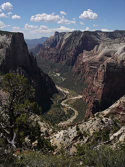
The Narrows is the narrowest section of Zion Canyon in Zion National Park, Utah, United States. Situated on the North Fork of the Virgin River and upstream of the main canyon, The Narrows is one of the premier hikes in the park and on the Colorado Plateau. The Narrows refers to both the 3.6-mile (5.8 km) bottom-up hike from the Temple of Sinawava to Big Springs, as well as the 16-mile (26 km) top-down hike from Chamberlain's Ranch back to the Temple of Sinawava.

Trail Ridge Road is the name for the 48-mile (77 km) stretch of U.S. Highway 34 that traverses Rocky Mountain National Park from Estes Park, Colorado in the east to Grand Lake, Colorado in the west. Together with the connecting 6.9-mile (11 km) Beaver Meadow Road, Trail Ridge Road forms the 55-mile (89 km) Trail Ridge Road/Beaver Meadow National Scenic Byway, an All-American Road. With a high point at 12,183 feet (3,713 m) elevation, Trail Ridge Road is the highest continuous paved road in North America. The higher portion of Trail Ridge Road is closed from October to May.

Going-to-the-Sun Road is a scenic mountain road in the Rocky Mountains of the western United States, in Glacier National Park in Montana. The Sun Road, as it is sometimes abbreviated in National Park Service documents, is the only road that traverses the park, crossing the Continental Divide through Logan Pass at an elevation of 6,646 feet (2,026 m), which is the highest point on the road. Construction began in 1921 and was completed in 1932 with formal dedication in the following summer on July 15, 1933. Prior to the construction of the road, visitors would need to spend several days traveling through the central part of the park, an area which can now be traversed within a few hours, excluding any stops for sightseeing or construction.

Colonial Parkway is a 23-mile (37 km) scenic parkway linking the three points of Virginia's Historic Triangle, Jamestown, Williamsburg, and Yorktown. It is part of the National Park Service's Colonial National Historical Park. Virginia's official state classification for the parkway is State Route 90003. With portions built between 1930 and 1957, it links the three communities via a roadway shielded from views of commercial development. The roadway is toll-free, is free of semi trucks, and has speed limits of around 35 to 45 mph. As a National Scenic Byway and All-American Road, it is also popular with tourists due to the James River and York River ends of the parkway.

Zion Canyon is a deep and narrow gorge in southwestern Utah, United States, carved by the North Fork of the Virgin River. Nearly the entire canyon is located within the western half of Zion National Park.

The Blackstone Canal was a waterway linking Worcester, Massachusetts, to Providence, Rhode Island through the Blackstone Valley via a series of locks and canals during the early 19th century. Construction was started in 1825, and the canal opened three years later. Following the opening of the Boston and Providence Railroad in 1835, the canal struggled for business. It was ultimately replaced by the Providence and Worcester Railroad, which completed a parallel line using much of the canal right-of-way in 1847, the canal shut down in 1848. Several segments of the canal are preserved.
The Utah Parks Company, a subsidiary of Union Pacific Railroad, owned and operated restaurants, lodging, and bus tours in Bryce Canyon and Zion National Parks, the north rim of Grand Canyon National Park, and Cedar Breaks National Monument from the 1920s until 1972. Operating as a concessionaire of the National Park Service, the company operated from a base in Cedar City, Utah. The company's bus tours connected there with Union Pacific trains as well as tour buses from Los Angeles, San Francisco and other west coast cities, and offered a loop tour of the region's parks and monuments, escorted by a Utah Parks Company driver/guide.

Mount Carmel Junction and Mount Carmel are unincorporated communities located 12 miles (19 km) east of Zion National Park and 17 miles (27 km) north of Kanab in Kane County, Utah, United States. They lie in close proximity to the Coral Pink Sand Dunes State Park.

State Route 128 (SR-128) is a 44.564-mile-long (71.719 km) state highway in the U.S. state of Utah. The entire length of the highway has been designated the Upper Colorado River Scenic Byway, as part of the Utah Scenic Byways program. This road also forms part of the Dinosaur Diamond Prehistoric Highway, a National Scenic Byway. Residents of Moab frequently refer to SR-128 as "the river road", after the Colorado River, which the highway follows.

Bryce Canyon Lodge is a lodging facility in Bryce Canyon National Park, Utah, United States, built between 1924 and 1925 using local materials. Designed by architect Gilbert Stanley Underwood, the lodge is an excellent example of National Park Service rustic design, and the only remaining completely original structure that Underwood designed for Bryce Canyon National Park, Zion National Park, and the North Rim of the Grand Canyon.
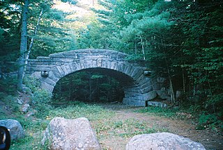
Acadia National Park, largely on Mount Desert Island, off the coast of the U.S. state of Maine, was created in part by land and other donations by John D. Rockefeller Jr. Between 1919 and 1931, Rockefeller, who was opposed to the introduction of automobiles on the island, personally oversaw the construction of a network of carriage roads, closed to motorized vehicles, on the eastern half of the island, including sixteen granite bridges and two gatehouses. The major portion of this network now falls within the bounds of the national park, and was listed on the National Register of Historic Places in 1979.

The Grand Loop Road is a historic district which encompasses the primary road system in Yellowstone National Park. Much of the 140-mile (230 km) system was originally planned by Captain Hiram M. Chittenden of the US Army Corps of Engineers in the early days of the park, when it was under military administration. The Grand Loop Road provides access to the major features of the park, including the Upper, Midway and Lower geyser basins, Mammoth Hot Springs, Tower Fall, the Grand Canyon of the Yellowstone and Yellowstone Lake.
Zion National Park is an American national park located in southwestern Utah near the town of Springdale. Located at the junction of the Colorado Plateau, Great Basin, and Mojave Desert regions, the park has a unique geography and a variety of life zones that allow for unusual plant and animal diversity. Numerous plant species as well as 289 species of birds, 75 mammals, and 32 reptiles inhabit the park's four life zones: desert, riparian, woodland, and coniferous forest. Zion National Park includes mountains, canyons, buttes, mesas, monoliths, rivers, slot canyons, and natural arches. The lowest point in the park is 3,666 ft (1,117 m) at Coalpits Wash and the highest peak is 8,726 ft (2,660 m) at Horse Ranch Mountain. A prominent feature of the 229-square-mile (590 km2) park is Zion Canyon, which is 15 miles (24 km) long and up to 2,640 ft (800 m) deep. The canyon walls are reddish and tan-colored Navajo Sandstone eroded by the North Fork of the Virgin River.

The Generals' Highway Stone Bridges, built in 1930, are part of the Generals' Highway from the General Grant Grove of giant sequoias in Kings Canyon National Park through Sequoia National Park. One bridge spans the Marble Fork of the Kaweah River in a wooded setting, while the other, similar bridge spans Clover Creek in a bare canyon.

The Zion – Mount Carmel Highway is a 25-mile (40 km) long road in Washington and Kane counties in southern Utah, United States, that is listed on the National Register of Historic Places and is a National Historic Civil Engineering Landmark.
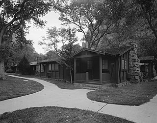
The Zion Lodge Historic District surrounds the rustic lodge originally designed by Gilbert Stanley Underwood in Zion National Park. The lodge served as the center of a group of cabins, employee dormitories and support buildings which are included in the district. A swimming pool and bathhouse were demolished in 1976. The district was expanded in 1986 to include an Underwood-designed former photography studio and additional cabins.

The historical buildings and structures of Zion National Park represent a variety of buildings, interpretive structures, signs and infrastructure associated with the National Park Service's operations in Zion National Park, Utah. Structures vary in size and scale from the Zion Lodge to road culverts and curbs, nearly all of which were designed using native materials and regional construction techniques in an adapted version of the National Park Service Rustic style. A number of the larger structures were designed by Gilbert Stanley Underwood, while many of the smaller structures were designed or coordinated with the National Park Service Branch of Plans and Designs. The bulk of the historic structures date to the 1920s and 1930s. Most of the structures of the 1930s were built using Civilian Conservation Corps labor.

The Yosemite Valley Bridges are eight bridges in the Yosemite Valley of Yosemite National Park, most of them spanning the Merced River. Five of them were built in 1928, with the remainder built between 1921 and 1933. The bridges feature a concrete structure faced with local stone, in an elliptical or three-centered arch configuration. They are notable for their uniform character and for their conformance to tenets of the National Park Service rustic style. Design work for the seven newer bridges was by George D. Whittle of the San Francisco District Office of the U.S. Bureau of Public Roads for the National Park Service. Concrete bridges were chosen at the urging of Thomas Chalmers Vint of the Park Service, in lieu of alternative designs for steel truss bridges, or suspension bridges suggested by the park superintendent.
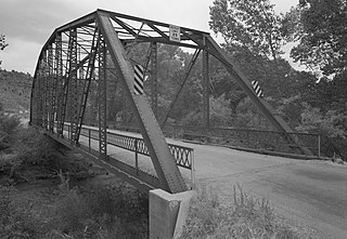
The Rockville Bridge spans the east fork of the Virgin River in Rockville, Utah, United States. The bridge was built for the National Park Service in 1924 to provide a link between Zion National Park and the North Rim area of Grand Canyon National Park. The new bridge allowed motorists to take a circular tour of the national parks in southern Utah and northern Arizona. The Rockville route was superseded in 1928 by the construction of the Zion-Mount Carmel Highway.
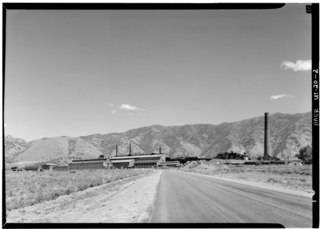
The International Smelting and Refining Company was a subsidiary of Anaconda Copper that operated primarily out of the International Smelter near Tooele, Utah. The International Smelter began operation in 1910 as a copper producer handling ores from Bingham Canyon and was expanded into a lead smelting operation in 1912. Copper smelting finished at International in 1946, and the lead smelter shut down in January 1972. The closure of the smelter would lead to the associated Tooele Valley Railway to be shut down ten years later in 1982. The company also handled several other Anaconda owned interests. After the shut down of several of the International Smelting sites, environmental reclamation has been performed by Anaconda Copper's successor company ARCO and the EPA Superfund program.