
Salt Lake County is located in the U.S. state of Utah. As of the 2020 United States census, the population was 1,185,238, making it the most populous county in Utah. Its county seat and largest city is Salt Lake City, the state capital. The county was created in 1850. Salt Lake County is the 37th most populated county in the United States and is one of four counties in the Rocky Mountains to make it into the top 100. Salt Lake County has been the only county of the first class in Utah – under the Utah Code is a county with a population of 700,000 or greater. Although, Utah County directly to the south has recently reached this threshold.

South Salt Lake is a city in Salt Lake County, Utah, United States and is part of the Salt Lake City Metropolitan Statistical Area. The population was 23,617 at the 2010 census.

Camp Floyd State Park Museum is a state park in the Cedar Valley in Fairfield, Utah, United States. The park includes a small part of the former Camp Floyd site, the Stagecoach Inn, and the Fairfield District School.

Sugar House is a neighborhood in Salt Lake City, Utah. The name is officially two words, although it is often colloquially written as "Sugarhouse." As a primary commercial and residential hub of the region, it is often referred to as Salt Lake's "Second Downtown." Once a primarily residential area with a suburban-style retail hub, the neighborhood has transformed in recent years as mid-rise offices, residential blocks, and hotels have been constructed in the vicinity of Sugar House Park.

Salt Lake City, Utah has many historic and notable sites within its immediate borders. Although the entire Salt Lake City metropolitan area is often referred to as "Salt Lake City", this article is concerned only with the buildings and sites within the official city limits of Salt Lake City.
Transportation in Salt Lake City consists of a wide network of roads, an extensive bus system, a light rail system, and a commuter rail line. Although Salt Lake City, Utah, is a traditionally car-oriented city, the rapidly growing public transit system has a high number of riders for a city of its size, and public transit is widely supported by its residents and businesses.

This is a list of properties and historic districts in Iowa that are listed on the National Register of Historic Places. There are listings in all of Iowa's 99 counties, adding up to over 2,300 total.
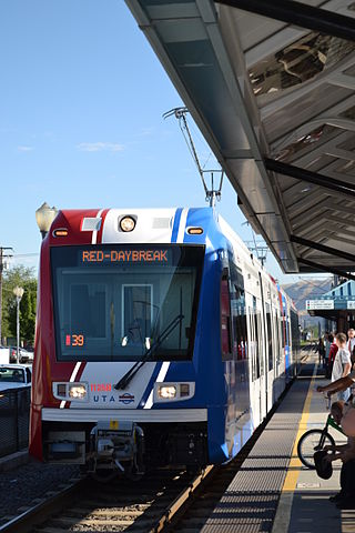
Central Pointe station is a light rail station in South Salt Lake, Utah, in the United States, served by all three lines of the Utah Transit Authority's (UTA) TRAX light rail system. In December 2013, the station also became the western terminus for the S Line.
The Crystal Lake and Pleasant Street Historic District encompasses a streetcar suburban residential subdivision developed between 1860 and 1895 in Newton, Massachusetts. The district roughly bounded by the Sudbury Aqueduct, Pleasant Avenue, Lake Avenue, and Crystal Street and Webster Court. The subdivision was laid out in the 1850s after the Boston and Charles Railroad line was extended through Newton from Brookline. The district was listed on the National Register of Historic Places in 1986.

Midtown has an area of six square miles in Columbus, Georgia. It possesses residential neighbourhoods, eleven public schools, the Columbus Museum, the Columbus Public Library, the Muscogee County Public Education Center, the Columbus Aquatic Center and the international headquarters for Aflac. The population of Midtown is 22,000 residents living in 8500 households and is 10 kilometres north of Fort Benning on I-185.

The S Line, or S-Line, is a public transit streetcar line in northeastern Salt Lake County, Utah, in the United States, that connects the business district of the Sugar House neighborhood of Salt Lake City with the neighboring city of South Salt Lake, as well as the Utah Transit Authority's (UTA) TRAX light rail system. It is a joint project between UTA, Salt Lake City, and South Salt Lake. It opened for service on December 8, 2013. It is operated by UTA and is UTA's first streetcar line.

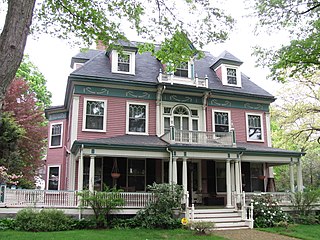
The George M. Cannon House, built in 1890, is an historic Late Victorian mansion located at 720 East Ashton Avenue in the Forest Dale area of Salt Lake City, Utah. It was designed by noted Salt Lake architect John A. Headlund for George Mousley Cannon, a member of the Cannon family, a prominent Intermountain West political family. In 1889 George M. Cannon had bought Forest Farm from the estate of Brigham Young and created the subdivision of Forest Dale and later the larger town of Forest Dale, which existed from 1902 until 1912, when it was reabsorbed into Salt Lake City. Brigham Young's Forest Farmhouse was moved in 1975 from its location near this house to the This Is The Place Heritage Park for restoration.
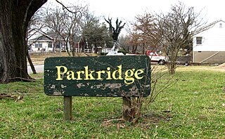
Parkridge is a neighborhood in Knoxville, Tennessee, United States, located off Magnolia Avenue east of the city's downtown area. Developed as a streetcar suburb for Knoxville's professional class in the 1890s, the neighborhood was incorporated as the separate city of Park City in 1907, and annexed by Knoxville in 1917. In the early 1900s, the neighborhood provided housing for workers at the nearby Standard Knitting Mill factory.
Ware & Treganza was a leading American architectural firm in the intermountain west during the late 19th and early 20th century. It was a partnership of Walter E. Ware and Alberto O. Treganza and operated in Salt Lake City, Utah.

The Knight–Mangum House is a historic house located in Provo, Utah, United States. It is listed on the National Register of Historic Places. The mansion was built in the old English Tudor style, completed in 1908. It was built for Mr. W. Lester Mangum and his wife Jennie Knight Mangum. Mrs. Mangum was the daughter of the famous Utah mining man, Jesse Knight. The lot was purchased for $3,500 and the home was built at a cost of about $40,000. The Mangum family was able to afford the home due to the fact that they had sold their shares in Jesse Knight's mine located in Tintic, Utah, for eight dollars a share. They had purchased the shares for only twenty cents a share, so the excess allowed them enough funds to purchase the home. The contractors for the home were the Alexandis Brothers of Provo.

The John R. Twelves House is a historic house located in Provo, Utah, United States. It is listed on the National Register of Historic Places.
The Sandy Historic District is a Historic District in Sandy, Utah, United States, that is listed on the National Register of Historic Places (NRHP) and covers most of the city's pre-suburbanization extent.
Highland Park is a neighborhood in Salt Lake City, just south of downtown Sugar House. The community originally was named for its lofty elevation. A large part of the neighborhood's core is recognized as the Highland Park Historic District. There is a small amount of retail along Highland Drive, but the area is otherwise residential. Forest Dale Golf Course forms the western boundary, Fairmont Park is to the northwest, and Sugar House Park and Highland High School are to the northeast separated from Highland Park by an underground reservoir and the 1300 East-Interstate 80 interchange.
The Perkins Addition was a 13-house development in Salt Lake City, Utah. Ten of its houses survived in 1983 and nine were each individually listed on the National Register of Historic Places.

Erected in 1930, the Sugar House Monument has long stood as a testament to the hard work of early Salt Lake pioneers making the valley sustainable.


