
Fort Sumter is a sea fort built on an artificial island protecting Charleston, South Carolina from naval invasion. Its origin dates to the War of 1812 when the British invaded Washington by sea. It was still incomplete in 1861 when the Battle of Fort Sumter began the American Civil War. It was severely damaged during the war, left in ruins, and although there was some rebuilding, the fort as conceived was never completed.

Colonial Heights is an independent city in the Commonwealth of Virginia. As of the 2020 census, the population was 18,170. The Bureau of Economic Analysis combines the City of Colonial Heights with Dinwiddie County for statistical purposes.

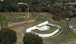
Fort Macon State Park is a North Carolina state park in Carteret County, North Carolina, in the United States. Located on Bogue Banks near Atlantic Beach, the park opened in 1936. Fort Macon State Park is the second most visited state park in North Carolina, with an annual visitation of 1.3 million, despite being one of the smallest state parks in North Carolina with 424 acres (1.72 km2). Fort Macon was built as part of the Third System of US fortifications, and was preceded by Fort Hampton of the Second System.
The Battle of Sewell's Point was an inconclusive exchange of cannon fire between the Union gunboat USS Monticello, supported by the USS Thomas Freeborn, and Confederate batteries on Sewell's Point that took place on May 18, 19 and 21, 1861, in Norfolk County, Virginia in the early days of the American Civil War. Little damage was done to either side. By the end of April 1861, USS Cumberland and a small number of supporting ships were enforcing the Union blockade of the southeastern Virginia ports at the southern end of the Chesapeake Bay and had captured several ships which attempted to pass the blockade. USS Monticello's bombardment of the Sewell's Point battery was one of the earliest Union Navy actions against Confederate forces during the Civil War. While it has been suggested by some sources that the Monticello's action may have been the first gunfire by the Union Navy during the Civil War, a brief exchange of cannon fire between the U.S. gunboat USS Yankee and shore batteries manned by Virginia volunteer forces which had not yet been incorporated into the Confederate States Army at Gloucester Point, Virginia on the York River occurred on May 7, 1861.

Fort Monroe, managed by partnership between the Fort Monroe Authority for the Commonwealth of Virginia, the National Park Service as the Fort Monroe National Monument, and the City of Hampton, is a former military installation in Hampton, Virginia, at Old Point Comfort, the southern tip of the Virginia Peninsula, United States. Along with Fort Wool, Fort Monroe originally guarded the navigation channel between the Chesapeake Bay and Hampton Roads—the natural roadstead at the confluence of the Elizabeth, the Nansemond and the James rivers. Union General George B. McClellan landed his forces at The fort during Peninsula campaign of 1862 during the American Civil War. Until disarmament in 1946, the areas protected by the fort were the entire Chesapeake Bay and Potomac River regions, including the water approaches to the cities of Washington, D.C. and Baltimore, Maryland, along with important shipyards and naval bases in the Hampton Roads area. Surrounded by a moat, the six-sided bastion fort is the largest fort by area ever built in the United States.

Fort Fisher was a Confederate fort during the American Civil War. It protected the vital trading routes of the port at Wilmington, North Carolina, from 1861 until its capture by the Union in 1865. The fort was located on one of Cape Fear River's two outlets to the Atlantic Ocean on what was then known as Federal Point or Confederate Point and today is known as Pleasure Island. The strength of Fort Fisher led to its being called the Southern Gibraltar and the "Malakoff Tower of the South". The battle of Fort Fisher was the most decisive battle of the Civil War fought in North Carolina.
Fort Barrancas (1839) or Fort San Carlos de Barrancas is a United States military fort and National Historic Landmark in the former Warrington area of Pensacola, Florida, located physically within Naval Air Station Pensacola, which was developed later around it.

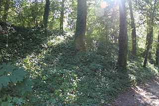
The Richmond National Battlefield Park commemorates 13 American Civil War sites around Richmond, Virginia, which served as the capital of the Confederate States of America for most of the war. The park connects certain features within the city with defensive fortifications and battle sites around it.
The Fort Mill Ridge Civil War Trenches are battle trenches in West Virginia that were originally dug between 1861 and 1862 to be later used in 1863 for the civil war. These trenches lined with chestnut logs by the Confederate artillery during the American Civil War to defend the approaches to Romney on the Northwestern Turnpike and the South Branch Potomac River. The trenches were then refurbished between March and June 1863 by the 54th Pennsylvania Infantry and the 1st West Virginia Infantry. When Colonel Jacob M. Campbell garrisoned Union forces at Romney, camps were set up at nearby at Mechanicsburg Gap. The Confederates might have created these trenches but all throughout the war the Union had control of these trenches.

The Battle of Grand Gulf was fought on April 29, 1863, during the American Civil War. As part of Major General Ulysses S. Grant's Vicksburg campaign, seven Union Navy ironclad warships commanded by Admiral David Dixon Porter bombarded Confederate fortifications at Grand Gulf, Mississippi. One of the Confederate fortifications, named Fort Wade, was silenced, but the other, named Fort Cobun, continued firing. Due to the strong Confederate resistance, Grant and Porter decided it was not feasible to make an amphibious landing at Grand Gulf, but later landed at Bruinsburg, Mississippi, instead. After the Confederates were defeated at the Battle of Port Gibson on May 1, Grand Gulf was rendered indefensible and the fortifications were abandoned. The defenders of Grand Gulf then fought at the Battle of Champion Hill on May 16 and the Battle of Big Black River Bridge on May 17, before the start of the Siege of Vicksburg, which ended with a Confederate surrender on July 4. Today, the battlefield is preserved in Grand Gulf Military State Park, which was listed on the National Register of Historic Places in 1972.
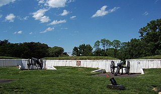
Fort Ward is a former Union Army installation now located in the city of Alexandria in the U.S. state of Virginia. It was the fifth largest fort built to defend Washington, D.C. in the American Civil War. It is currently well-preserved with 90-95% of its earthen walls intact.

The Battle of Galveston Harbor was fought at Galveston, Texas on October 4, 1862, during the American Civil War. After attempts to blockade the Texas coastline were unsuccessful, the Union Navy decided to attempt to capture the port of Galveston. While Galveston was defended by Confederate forces, most of the cannons in the city's defenses were removed, as Galveston was thought to be indefensible. On October 4, five Union naval vessels commanded by Commander William B. Renshaw approached Galveston, and a single ship, USRC Harriet Lane was sent into Galveston Bay under a flag of truce.

Fort Jackson was an American Civil War-era fortification in Virginia that defended the southern end of the Long Bridge, near Washington, D.C. Long Bridge connected Washington, D.C. to Northern Virginia and served as a vital transportation artery for the Union Army during the war. Fort Jackson was named for Jackson City, a seedy suburb of Washington that had been established on the south side of the Long Bridge in 1835. It was built in the days immediately following the Union Army's occupation of Northern Virginia in May 1861. The fort was initially armed with four cannon used to protect the bridge, but these were removed after the completion of the Arlington Line, a line of defenses built to the south. After 1862, the fort lacked weapons except for small arms and consisted of a wooden palisade backed by earthworks. Two cannon were restored to the fort in 1864 following the Battle of Fort Stevens. The garrison consisted of a single company of Union soldiers who inspected traffic crossing the bridge and guarded it from potential saboteurs.

Fort Anderson is a mid-19th-century earthen fort in the lower Cape Fear Region of North Carolina, located over the ruins of the colonial town of Brunswick in Brunswick County. It was built as a Confederate Fort by major general Samuel Gibbs French during the American Civil War. The fort was pivotal in protecting the Cape Fear River inlets and Wilmington upstream. Earthen batteries comprise the fort and were used as platforms and shields for the Confederate cannons. Beneath some of the earthworks were "bombproofs," shelters used by troops during enemy bombardment. The Confederacy decided to build forts around the Cape Fear River to protect the port of Wilmington from the Union blockade. During the Civil War, blockade runners brought supplies such as iron, guns, and ammunition to the Confederacy. The purpose of the fort was to hinder movement of Union ships, and to serve as a dropping off point for blockade runners fortunate enough to make it up the mouth of the Cape Fear River. Fort Anderson was built on the ruins of Brunswick Town and was originally named Fort St. Philip, after the ruins of the Revolutionary period church nearby. The name was changed to honor Col. George B. Anderson.
Fort Pemberton was one of the larger confederate forts was constructed in the defense of Charleston, South Carolina during the American Civil War. When Charleston was overwhelmed by Union forces in 1861, it became evident that control of the western regions of James Island and the Stono River was to be an important element in the defense of the city. Confederate military authorities of the time believed that Union occupation of James Island would leave Charleston subject to attack from the southeast. From this position the city would assuredly fall to the Union. Although there were many gun batteries in place along the south and east side of James Island, Fort Pemberton was the only fortress in defense of this region.

Fort Huger is a historic archaeological site located near Smithfield, Isle of Wight County, Virginia. The site is the location of an abandoned American Civil War fort on the south side of the James River across from Fort Eustis/Mulberry Point. It was named for Major General Benjamin Huger, commander of the Confederate States Army's Department of Norfolk at the time it was built. Fort Huger was an integral part of the Confederate Army's James River defenses in late summer 1861 through spring 1862.
Fort Crafford is a historic archaeological site located at Fort Eustis, Newport News, Virginia. It is a pentagonal-shaped earthwork located on Mulberry Island and built by Confederate forces in 1862. The earthworks on Mulberry Island are considered part of the Warwick Line. The purpose of these works was to prevent the Union from flanking the line on the James River. The fort formed the James River terminus of the second trans-peninsula defensive line, which included fortifications at Lee's Mill, as well as Dam No.1 and Wynne's Mill in Newport News Park.

Battery Rock is a limestone bluff located at Mile 860 of the Ohio River in Hardin County, Illinois, across from Caseyville, Kentucky. The bluff is a prominent navigational landmark along the river.
Fort Boykin is a historic site in Isle of Wight County, Virginia, located along the James River. The history of the site is believed to date back to 1623 when colonists were ordered to build a fort to protect them from attacking Native Americans or Spanish marauders. Today the remains of the fort, mostly from the American Civil War, are preserved in a public park.
The Civil War Trust's Civil War Discovery Trail is a heritage tourism program that links more than 600 U.S. Civil War sites in more than 30 states. The program is one of the White House Millennium Council's sixteen flagship National Millennium Trails. Sites on the trail include battlefields, museums, historic sites, forts and cemeteries.


