Fort Lawton Air Force Station

Last updated
Fort Lawton Air Force Station
Air Defense Command.svg
Part of Air Defense Command (ADC)
USA Washington location map.svg
Red pog.svg
Fort Lawton AFS
Location of Fort Lawton AFS, Washington
Coordinates 47°39′27″N122°24′47″W / 47.65750°N 122.41306°W / 47.65750; -122.41306 (Fort Lawton AFS RP-1) Coordinates: 47°39′27″N122°24′47″W / 47.65750°N 122.41306°W / 47.65750; -122.41306 (Fort Lawton AFS RP-1)
TypeAir Force Station
CodeADC ID: RP-1, NORAD ID: Z-1
Site information
Controlled byFlag of the United States Air Force.svg  United States Air Force
Site history
Built1961
In use1961–1963
Garrison information
Garrison635th Aircraft Control and Warning Squadron
Map all coordinates using: OpenStreetMap  
Download coordinates as: KML

Fort Lawton Air Force Station is a closed United States Air Force General Surveillance Radar station. It is located on Fort Lawton in the Magnolia neighborhood of northwest Seattle, Washington. The Air Force inactivated its unit in 1963; while the site remained under Army control until 1974. Today the Federal Aviation Administration (FAA) operates the site as part of the Joint Surveillance System (JSS).

Contents

History

The station was established at Fort Lawton, Washington on 1 April 1960 by Air Defense Command. The station was established as a consolidation of Army and Air Force radar units in the Seattle area due to funding reductions. Fort Lawton AFS was given the ADC designation "RP-1", as it replaced the radars at McChord AFB which were relocated as part of the consolidation. In addition, the station was a joint-use facility with the Federal Aviation Administration (FAA).

The Army established Army Air Defense Command Post S-90DC at the station for Nike missile command-and-control functions. The station was initially an AN/FSG-l Missile-Master Nike Radar Direction Center. It was later equipped with the AN/GSG-5(V) BIRDIE solid-state computer system. Among the Army air defense units operating in the area were the 26th Artillery Group (Air Defense) (1961–1966), 49th Artillery Group (AD) (1966–1974), 433d AA Battalion (1955–56), 4th Battalion, 4th Air Defense Artillery Regiment (1964–1972), and 1st Battalion, 4th ADA (1972–1974). [1]

The Air Force 635th Aircraft Control and Warning Squadron worked jointly with Army radar controllers at the station. The site used an FAA ARSR-1C search radar and two Air Force AN/FPS-6A height-finder radars. (The Army also had 2 AN/FPS-6 variant height-finder radars of their own.) On 11 June, Fort Lawton AFS joined the Semi Automatic Ground Environment (SAGE) system, feeding data to DC-12 at McChord AFB. After joining, the squadron was re-designated as the 635th Radar Squadron (SAGE). The radar squadron provided information 24/7 the SAGE Direction Center where it was analyzed to determine range, direction altitude speed and whether aircraft were friendly or hostile.

In addition to the main facility, Fort Lawton operated an AN/FPS-14 Gap Filler site:

In late 1962, an AN/FPS-26 height-finder radar was installed. On 31 December 1962, Air Force moved the 635th RADS to Dauphin Island AFS, Alabama, however a detachment operated at Fort Lawton until March 1963. The Army continued operations at the site until the AADCP was inactivated 1 September 1974.

The Fort Lawton radar site remains in use by the FAA today, still operating the ARSR-1E search radar.

Radar Site at Fort Lawton WA circa 1962.jpg
This image shows several types of radar systems, operated by several agencies, at Ft Lawton, WA. The two radars without radomes are US Army FPS-6 heightfinders; the radome with an open steel grid support structure is a search radar operated by the Federal Aviation Administration; the two radars with radomes and white clad support structure are US Air Force FPS-6A heightfinders; and the radome in the foreground with dark-clad support structure is a US Air Force FPS-26A, nearing construction completion here c. 1962.

See also

Related Research Articles

Empire Air Force Station is a former United States Air Force Aerospace Defense Command (ADC) long range radar site located 0.7 miles (1.1 km) south-southeast of Empire, Michigan, in Empire Township. It was closed in 1978 by the Air Force, and turned over to the Federal Aviation Administration (FAA).

<span class="mw-page-title-main">Ground Equipment Facility J-33</span> Federal Aviation Administration (FAA) radar station

Ground Equipment Facility J-33 is a Federal Aviation Administration (FAA) radar station of the Joint Surveillance System's Western Air Defense Sector (WADS) with an Air Route Surveillance Radar (ARSR-4). The facility was previously a USAF general surveillance radar station during the Cold War.

<span class="mw-page-title-main">Finley Air Force Station</span> Former US Air Force radar station

Finley Air Force Station is a closed United States Air Force General Surveillance Radar station. It is located 1.5 miles (2.4 km) west-northwest of Finley, North Dakota. It was closed in 1979 by the Air Force, and turned over to the Federal Aviation Administration (FAA).

<span class="mw-page-title-main">North Truro Air Force Station</span> Closed United States Air Force General Surveillance Radar station

North Truro Air Force Station (AFS) is a closed United States Air Force General Surveillance Radar station. It is located 2.2 mi (3.5 km) east of North Truro, Massachusetts.

<span class="mw-page-title-main">Gibbsboro Air Force Station</span>

Gibbsboro Air Force Station is a closed United States Air Force General Surveillance Radar station. It is located 1.1 miles (1.8 km) south-southeast of Gibbsboro, in Camden County, New Jersey, United States. It was closed in 1994 by the Air Force, and turned over to the Federal Aviation Administration (FAA).

Bedford Air Force Station is a closed United States Air Force General Surveillance Radar station. It is located 12.7 miles (20.4 km) north of Bedford, Virginia. It was closed in 1975.

Oakdale Air Force Station is a United States Air Force General Surveillance Radar station. It is located 1.3 miles (2.1 km) east of the Pittsburgh suburb of Oakdale, Pennsylvania. It was closed in 1969.

<span class="mw-page-title-main">Joelton Air Force Station</span> Former USAF radar station

Joelton Air Force Station is a closed United States Air Force General Surveillance Radar station. It is located 8.3 miles (13.4 km) west of Goodlettsville, Tennessee. It was closed in 1960.

<span class="mw-page-title-main">Kirksville Air Force Station</span> Former US Air Force radar station in Missouri

Kirksville Air Force Station is a closed United States Air Force General Surveillance Radar station. It is located 7.1 miles (11.4 km) north of Kirksville, Missouri. It was closed by the Air Force in 1968. Today the radar site is used by the Federal Aviation Administration (FAA) as a Joint Surveillance System (JSS) site.

Dauphin Island Air Force Station is a closed United States Air Force General Surveillance Radar station. It is located 1.9 miles (3.1 km) east of Dauphin Island, Alabama, near historic Fort Gaines (Alabama). It was closed in 1980.

Port Austin Air Force Station is a closed United States Air Force General Surveillance Radar station. It is located 1.2 miles (1.9 km) south-southwest Port Austin, Michigan. It was closed in 1988 by the Air Force.

Omaha Air Force Station is a closed United States Air Force General Surveillance Radar station. It is located 7.5 miles (12.1 km) north of Omaha, Nebraska. It was closed in 1968.

<span class="mw-page-title-main">Ground Equipment Facility J-31</span> Former radar station in California, US

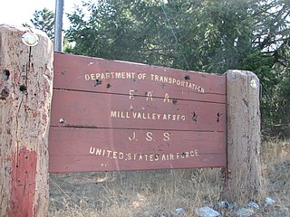
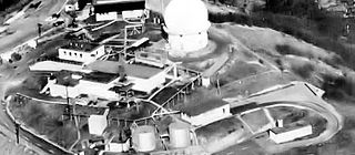
Ground Equipment Facility J-31 is a Joint Surveillance System radar site of the Western Air Defense Sector (WADS) and the Federal Aviation Administration's air traffic control radar network for the Los Angeles Air Route Traffic Control Center. The facility's Air Route Surveillance Radar Model 1E with an ATCBI-6 beacon interrogator system are operated by the FAA and provide sector data to North American Aerospace Defense Command. The site provided Semi-Automatic Ground Environment data to the 1959-66 Norton AFB Direction Center for the USAF Los Angeles Air Defense Sector. The site also provided Project Nike data to the 1960-74 Fort MacArthur Direction Center ~3 mi (4.8 km) away for the smaller US Army Los Angeles Defense Area—as well as gap-filler radar coverage for the 1963-74 Integrated Fire Control area of Malibu Nike battery LA-78 on San Vicente Mountain.

Ground Equipment Facility J-36A is a Federal Aviation Administration (FAA) radar station of the Joint Surveillance System (JSS) in the Western Air Defense Sector (WADS) of NORAD.

<span class="mw-page-title-main">Mount Laguna Air Force Station</span> Closed United States Air Force General Surveillance Radar station

Mount Laguna Air Force Station is a closed United States Air Force General Surveillance Radar station. It is located 24.3 miles (39.1 km) north-northeast of Tecate, California. It was closed in 1981 by the Air Force, and turned over to the Federal Aviation Administration (FAA).

<span class="mw-page-title-main">Klamath Air Force Station</span> Closed United States Air Force General Surveillance Radar station

Klamath Air Force Station is a closed United States Air Force General Surveillance Radar station. It is located 3.4 miles (5.5 km) northwest of Klamath, California. It was closed in 1981.

<span class="mw-page-title-main">Ground Equipment Facility J-82</span> Closed United States Air Force General Surveillance Radar station

Keno Air Force Station is a closed United States Air Force General Surveillance Radar station. It is located 4.6 miles (7.4 km) south-southwest of Keno, Oregon. It was closed in 1979 by the Air Force, and turned over to the Federal Aviation Administration (FAA).

Mica Peak Air Force Station is a closed United States Air Force General Surveillance Radar station. It is located atop Mica Peak, 6.3 miles (10.1 km) east-northeast of Mica, Washington. It was closed in 1975 by the Air Force, and turned over to the Federal Aviation Administration (FAA).

<span class="mw-page-title-main">Kalispell Air Force Station</span>

Kalispell Air Force Station is a closed United States Air Force General Surveillance Radar station. It is located 13.3 miles (21.4 km) south of Kalispell, Montana near the community of Lakeside.

Makah Air Force Station is a closed United States Air Force General Surveillance Radar station. It is located 2.4 miles (3.9 km) south of Neah Bay, Washington. It was closed in 1988 by the Air Force, and turned over to the Federal Aviation Administration (FAA).

References

PD-icon.svg This article incorporates public domain material from the Air Force Historical Research Agency.

  1. Morgan and Berhow, Rings of Supersonic Steel, 166.