
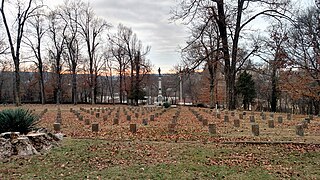
Camp Nelson Confederate Cemetery is a historic cemetery located near Cabot in northern Lonoke County, Arkansas and is near the site of a Confederate military camp Camp Hope, where 1,500 Confederate soldiers died during an epidemic during the fall of 1862. Camp Nelson Cemetery is located on Rye Drive, just off Cherry Road, just off Mt. Carmel Road in north Lonoke County about 2 miles east of Cabot.

San Marcos de Apalache Historic State Park is a Florida State Park in Wakulla County, Florida organized around the historic site of a Spanish colonial fort, which was used by succeeding nations that controlled the area. The Spanish first built wooden buildings and a stockade in the late 17th and early 18th centuries here, which were destroyed by a hurricane.
Fort Fillmore, located at 32°13′30″N 106°42′52″W, was a United States military fortification established by Colonel Edwin Vose Sumner in September 1851 near Mesilla in what is now New Mexico, primarily for the purpose of protecting settlers and traders traveling to California. Early frontier migrants were under constant threat from attack by local Native Americans, and a network of forts was eventually created by the U.S. government to protect and encourage westward expansion. Fort Fillmore was intended to protect a corridor plagued by hostile Apaches, where several migration routes converged between El Paso and Tucson to take advantage of Apache Pass.

Baton Rouge National Cemetery is a United States National Cemetery located in East Baton Rouge Parish, in the city of Baton Rouge, Louisiana. It encompasses 7.7 acres (3.1 ha), and as of 2020, had over 5,000 interments.

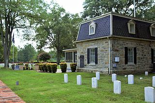
Finn's Point National Cemetery is a United States National Cemetery located in Pennsville Township, Salem County, New Jersey, United States. It encompasses 4.6 acres (1.9 ha), and as of February 2009, had 3,033 interments. Adjacent to Fort Mott, it is governed by the United States Department of Veterans Affairs and administered by the Washington Crossing National Cemetery.
Fort Harrison National Cemetery is a United States National Cemetery located seven miles (11 km) south of the city of Richmond, in Henrico County, Virginia. Administered by the United States Department of Veterans Affairs, It encompasses 1.5 acres (0.61 ha), and as of the end of 2005, had 1,570 interments.
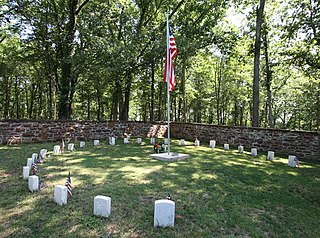
Ball's Bluff Battlefield Regional Park and National Cemetery is a battlefield area and a United States National Cemetery, located 2 miles (3.2 km) northeast of Leesburg, Virginia. The cemetery is the third smallest national cemetery in the United States. Fifty-four Union Army dead from the Battle of Ball's Bluff are interred in 25 graves in the half-acre plot; the identity of all of the interred except for one, James Allen of the 15th Massachusetts, are unknown. Monuments to fallen Confederate Sergeant Clinton Hatcher and Union brigade commander Edward Dickinson Baker are located next to the cemetery, though neither is buried there. While the stone wall-enclosed cemetery itself is managed through the Culpeper National Cemetery and owned by the Department of Veterans Affairs, the balance of the 223-acre (0.90 km2) park is managed through the Northern Virginia Regional Park Authority.
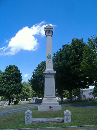
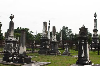
The Latham Confederate Monument in Hopkinsville, Kentucky's Riverside Cemetery, is a monument on the National Register of Historic Places.

The Lakeside Cemetery Chapel is a historic chapel in Lakeside Cemetery, on North Avenue in Wakefield, Massachusetts. The stone chapel, built 1913, is one of a few Neo-Gothic buildings in the town. Roughly resembling English country churches, the building has a steeply pitched slate roof, with sidewalls containing supporting buttresses. The front and rear of the chapel both have projecting entry sections that repeat the sharply pitched gable.

Grand Gulf Military State Park is a Mississippi state park located 10 miles northwest of Port Gibson in an unincorporated area, now the ghost town of Grand Gulf, in Claiborne County, Mississippi. The park includes the remnants of two batteries that fired on and repelled Ulysses S. Grant's forces during the Battle of Grand Gulf. After the Battle of Port Gibson, Grant made Grand Gulf his base of operations. It is listed on the National Register of Historic Places and is a Mississippi Landmark.

Fort Golgotha and the Old Burial Hill Cemetery is the site of an historic cemetery, officially known as the "Old Burying Ground", and the location of a former Revolutionary War-era fort, known as Fort Golgotha, at Main Street and Nassau Road in Huntington, New York. It is located in the Old Town Green Historic District and Old Town Hall Historic District.
WPA Stone Structures in Memorial Park and Calvary Cemetery, in Grand Forks, North Dakota, was listed on the National Register of Historic Places in 2010. It includes work by Ray F. Wyrick, "'a noted cemetery landscape engineer' from Des Moines, IA, who consulted as a WPA design advisor all over the country." The listing includes "two sets of stone entrance gateways, one relocated set of stone entry cairns, and a stone chapel building." It is believed that Wyrick made provided overall design of general cemetery layout and designed a reflecting pool for the cemetery, too.
Fayetteville Confederate Cemetery is a cemetery for soldiers of the Confederate States located on the eastern side of Fayetteville in Washington County, Arkansas. Added to the National Register of Historic Places (NRHP) in 1993, the cemetery encompasses 3.5 acres (1.4 ha).

The Oakland Cemetery is a 40-acre (16 ha) public cemetery maintained by the city of Fort Dodge, Iowa, United States. Property for the cemetery was set aside in 1859. It was laid out the same year by Egbert Bagg, an architect and civil engineer from Utica, New York. The graves and monuments are arranged around the natural contours of the hills that overlook Soldier Creek in a natural park-like setting. It is considered a good and rare example of a rural cemetery in North Central Iowa. It has been listed as an historic district on the National Register of Historic Places since 2000.
The Old City Cemetery, also known as Linwood Cemetery, is a 28.7-acre (11.6 ha) cemetery on what is now Linwood Boulevard, in Columbus, Georgia. It dates from 1828, when the town of Columbus was founded, or before. It appears in surveyor Edward Lloyd Thomas's original plan for the city. The cemetery consists mostly of rectangular family plots bordered by iron fences or walls made of brick or granite, accessed by a main east-west corridor and perpendicular lanes. It includes both simple and elaborate tombstones, some displaying Egyptian Revival or Gothic styles.

Lindenwood Cemetery is a rural cemetery operated by Dignity Memorial in Fort Wayne, Indiana, established in 1859. With over 74,000 graves and covering 175 acres (0.71 km2), it is one of the largest cemeteries in Indiana.

Spratt Cemetery is a historic family cemetery located near Fort Mill, York County, South Carolina. It contains graves of three generations of the Spratt family, and other early settlers of the Fort Mill area. The cemetery consists of 14 marked graves and approximately 9 graves with broken stones or partial markers. It includes the grave of Thomas "Kanawha" Spratt, one of the first settlers of the area, and located adjacent to the site his homestead along Nation Ford Road. The land was provided for the Spratt homestead by the General New River, leader of the Catawba tribe.
Sharon Cemetery Historic District is located in rural Harrison Township, Lee County, Iowa, United States near the town of Farmington. It was listed on the National Register of Historic Places in 1991. At the time of its nomination the historic district included four contributing buildings, one contributing site, eight contributing structures, and one contributing object.

The Lorenzo S. Coffin Burial Plot is a historic structure located northwest of Fort Dodge, Iowa, United States. Initially, the various members of the Coffin family had individual grave markers, but after Lorenzo Coffin's death, they were incorporated into a concrete wall. The surrounding graves are those of non-family members. The Coffin family home was originally to the west of the grave site. It was listed on the National Register of Historic Places in 1977.

Fry Pioneer Cemetery is the original cemetery in Fry, Arizona, which was the name of Sierra Vista prior to its renaming and incorporation in 1956. It is a half-acre site, and includes more than 200 known graves, most of which are unmarked. It has sparse vegetation and is surrounded by a chain-link fence.

