Fountain City, Indiana

Last updated

Fountain City, Indiana
Fountaincity, Indiana.jpg
Wayne County Indiana Incorporated and Unincorporated areas Fountain City Highlighted 1825090.svg
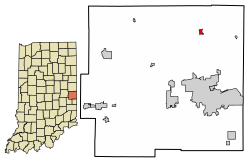
Location of Fountain City in Wayne County, Indiana.
Coordinates: 39°57′16″N84°55′12″W / 39.95444°N 84.92000°W / 39.95444; -84.92000
Country United States
State Indiana
County Wayne
Township New Garden
Area
[1]
  Total0.26 sq mi (0.68 km2)
  Land0.26 sq mi (0.68 km2)
  Water0.00 sq mi (0.00 km2)
Elevation
[2]
1,106 ft (337 m)
Population
 (2020)
  Total714
  Density2,704.55/sq mi (1,045.00/km2)
Time zone UTC-5 (Eastern (EST))
  Summer (DST) UTC-5 (EST)
ZIP code
47341
Area code 765
FIPS code 18-25090 [3]
GNIS feature ID 434712
Website https://fountaincity.municipalimpact.com/

Fountain City, formerly Newport, is a town in New Garden Township, Wayne County, in the U.S. state of Indiana. [4] The population was 796 at the 2010 census.

Contents

History

Fountain City was originally called New Garden, and under the latter name was laid out in 1818. [5] [6] [7] New Garden became Newport in 1834, which was renamed Fountain City in 1878, [7] named for its natural springs. [8] It was incorporated as a town in 1844. [5]

The Fountain City post office has been in operation since 1878. [9]

Historic site

Levi Coffin House, Fountain City, Indiana Levi Coffin House, front and southern side.jpg
Levi Coffin House, Fountain City, Indiana

The Levi Coffin House, home of Quaker abolitionist Levi Coffin and his wife Catherine, was an important stop on the Underground Railroad. Coffin was sometimes known as the "president" of the Underground Railroad. It is now operated as an Indiana State Historic Site. [10]

Geography

Fountain City is located at 39°57′16″N84°55′12″W / 39.95444°N 84.92000°W / 39.95444; -84.92000 (39.954525, -84.919890). [11]

According to the 2010 census, Fountain City has a total area of 0.26 square miles (0.67 km2), all land. [12]

Demographics

Historical population
CensusPop.Note
1880 471
1890 4924.5%
1900 455−7.5%
1910 448−1.5%
1920 375−16.3%
1930 48028.0%
1940 4912.3%
1950 58819.8%
1960 83341.7%
1970 8522.3%
1980 839−1.5%
1990 766−8.7%
2000 735−4.0%
2010 7968.3%
2020 714−10.3%
U.S. Decennial Census [13]

2010 census

As of the census [14] of 2010, there were 796 people, 311 households, and 221 families living in the town. The population density was 3,061.5 inhabitants per square mile (1,182.1/km2). There were 343 housing units at an average density of 1,319.2 per square mile (509.3/km2). The racial makeup of the town was 97.2% White, 0.9% African American, 0.1% Asian, and 1.8% from two or more races. Hispanic or Latino of any race were 0.1% of the population.

There were 311 households, of which 39.5% had children under the age of 18 living with them, 48.6% were married couples living together, 15.1% had a female householder with no husband present, 7.4% had a male householder with no wife present, and 28.9% were non-families. 24.4% of all households were made up of individuals, and 8.7% had someone living alone who was 65 years of age or older. The average household size was 2.56 and the average family size was 3.00.

The median age in the town was 37.6 years. 27.6% of residents were under the age of 18; 9% were between the ages of 18 and 24; 24.6% were from 25 to 44; 24.3% were from 45 to 64; and 14.6% were 65 years of age or older. The gender makeup of the town was 47.0% male and 53.0% female.

2000 census

As of the census [3] of 2000, there were 735 people, 291 households, and 212 families living in the town. The population density was 2,795.5 inhabitants per square mile (1,079.3/km2). There were 309 housing units at an average density of 1,175.2 per square mile (453.7/km2). The racial makeup of the town was 97.69% White, 0.68% African American, 0.27% Asian, 0.27% from other races, and 1.09% from two or more races. Hispanic or Latino of any race were 0.27% of the population.

There were 291 households, out of which 33.7% had children under the age of 18 living with them, 58.8% were married couples living together, 11.3% had a female householder with no husband present, and 27.1% were non-families. 24.4% of all households were made up of individuals, and 10.0% had someone living alone who was 65 years of age or older. The average household size was 2.53 and the average family size was 2.95.

In the town, the population was spread out, with 26.0% under the age of 18, 8.3% from 18 to 24, 29.3% from 25 to 44, 22.4% from 45 to 64, and 14.0% who were 65 years of age or older. The median age was 36 years. For every 100 females, there were 95.0 males. For every 100 females age 18 and over, there were 94.3 males.

The median income for a household in the town was $34,722, and the median income for a family was $40,865. Males had a median income of $32,031 versus $21,000 for females. The per capita income for the town was $15,669. About 7.4% of families and 8.8% of the population were below the poverty line, including 10.3% of those under age 18 and 10.9% of those age 65 or over.

Notable people

Related Research Articles

<span class="mw-page-title-main">Wayne County, Indiana</span> County in Indiana, United States

Wayne County is a county located in east central Indiana, United States, on the border with Ohio. As of the 2020 United States Census, the population was 66,553. The county seat is Richmond.

<span class="mw-page-title-main">Waterloo, Indiana</span> Town in Indiana, United States

Waterloo is a town in Grant and Smithfield townships, DeKalb County, Indiana, United States. The population was 2,242 at the 2010 census.

<span class="mw-page-title-main">Chesterfield, Indiana</span> Town in Indiana, United States

Chesterfield is a town in the U.S. state of Indiana which lies in Union Township, Madison County, and Salem Township, Delaware County. The population was 2,490 at the 2020 census. It is part of the Indianapolis–Carmel–Anderson metropolitan statistical area.

<span class="mw-page-title-main">Hillsboro, Indiana</span> Town in Indiana, United States

Hillsboro is a town in Cain Township, Fountain County, Indiana, United States. Its population was 538 at the 2010 census.

<span class="mw-page-title-main">Kingman, Indiana</span> Town in Indiana, United States

Kingman is a town in Millcreek Township, Fountain County, Indiana, United States. The population was 511 at the 2010 census.

<span class="mw-page-title-main">Mellott, Indiana</span> Town in Indiana, United States

Mellott is a town in Richland Township, Fountain County, Indiana, United States. The population was 197 at the 2010 census. On November 17, 2013, a tornado hit Mellott.

<span class="mw-page-title-main">Newtown, Indiana</span> Town in Indiana, United States

Newtown is a town in Richland Township, Fountain County, Indiana, United States. The population was 256 at the 2010 census.

<span class="mw-page-title-main">Veedersburg, Indiana</span> Town in Indiana, United States

Veedersburg is a town in Van Buren Township, Fountain County, Indiana, United States. The population was 2,180 at the 2010 census.

<span class="mw-page-title-main">Wallace, Indiana</span> Town in Indiana, United States

Wallace, originally named Jacksonville, is a town located in Jackson Township, Fountain County, Indiana, United States. At the 2010 census, the town had a total population of 105.

<span class="mw-page-title-main">Dunreith, Indiana</span> Town in Indiana, United States

Dunreith is a town in Spiceland Township, Henry County, Indiana, United States. The population was 177 at the 2010 census.

<span class="mw-page-title-main">Mount Etna, Indiana</span> Town in Indiana, United States

Mount Etna is a town in Huntington County, Indiana, United States. The population was 94 at the 2010 census. It lies at the intersection of four townships: Jefferson, Lancaster, Polk and Wayne.

<span class="mw-page-title-main">Leesburg, Indiana</span> Town in Indiana, United States

Leesburg is a town in Plain Township, Kosciusko County, in the U.S. state of Indiana. The population was 978 at the 2020 census. The town of Leesburg was laid out in 1833 by Levi Lee. It includes the Leesburg Historic District.

<span class="mw-page-title-main">Waynetown, Indiana</span> Town in Indiana, United States

Waynetown is a town in Wayne Township, Montgomery County, in the U.S. state of Indiana. The population was 960 at the 2020 census.

<span class="mw-page-title-main">Boston, Indiana</span> Town in Indiana, United States

Boston is a town in Boston Township, Wayne County, Indiana, United States. The population was 138 at the 2010 census.

<span class="mw-page-title-main">East Germantown, Indiana</span> Town in Indiana, United States

East Germantown is a town in Jackson Township, Wayne County, in the U.S. state of Indiana. The population was 410 at the 2010 census.

<span class="mw-page-title-main">Milton, Indiana</span> Town in Indiana, United States

Milton is a town in Washington Township, Wayne County, in the U.S. state of Indiana. The population was 490 at the 2010 census.

<span class="mw-page-title-main">Mount Auburn, Indiana</span> Town in Indiana, United States

Mount Auburn is a town in Jackson Township, Wayne County, in the U.S. state of Indiana. The population was 117 at the 2010 census. The town is sandwiched between Dublin and Cambridge City.

<span class="mw-page-title-main">Spring Grove, Indiana</span> Town in Indiana, United States

Spring Grove is a town in Wayne Township, Wayne County, in the U.S. state of Indiana. The population was 344 at the 2010 census.

<span class="mw-page-title-main">Ossian, Indiana</span> Town in Indiana, United States

Ossian is a town in Jefferson Township, Wells County, in the U.S. state of Indiana. The town was named after Ossian, the narrator of a cycle of epic poems by the Scottish poet James Macpherson. The population was 3,289 at the 2010 census.

<span class="mw-page-title-main">Hagerstown, Indiana</span> Town in Indiana, United States

Hagerstown is a town in Jefferson Township, Wayne County, in the U.S. state of Indiana. As of the 2010 census, the population was 1,787.

References

  1. "2020 U.S. Gazetteer Files". United States Census Bureau. Retrieved March 16, 2022.
  2. "US Board on Geographic Names". United States Geological Survey. October 25, 2007. Retrieved July 7, 2016.
  3. 1 2 "U.S. Census website". United States Census Bureau . Retrieved January 31, 2008.
  4. "Fountain City, Indiana". Geographic Names Information System . United States Geological Survey, United States Department of the Interior . Retrieved July 7, 2016.
  5. 1 2 Young, Andrew White (1872). History of Wayne County, Indiana, from Its First Settlement to the Present Time. R. Clarke & Company. pp.  298.
  6. "Fountain City, Indiana". WayNet. Retrieved June 2, 2014.
  7. 1 2 History of Wayne County, Indiana: Together with Sketches of Its Cities, Villages and Towns, Volume 2. Inter-State Publishing Company. 1884.
  8. "Profile for Fountain City, IN". ePodunk . Retrieved July 7, 2016.
  9. "Wayne County". Jim Forte Postal History. Archived from the original on September 14, 2005. Retrieved July 7, 2016.
  10. "Levi Coffin House". WayNet. Retrieved June 2, 2014.
  11. "US Gazetteer files: 2010, 2000, and 1990". United States Census Bureau. February 12, 2011. Retrieved April 23, 2011.
  12. "G001 - Geographic Identifiers - 2010 Census Summary File 1". United States Census Bureau. Archived from the original on February 13, 2020. Retrieved July 16, 2015.
  13. "Census of Population and Housing". Census.gov. Retrieved June 4, 2015.
  14. "U.S. Census website". United States Census Bureau . Retrieved December 11, 2012.