
Logan Circle is a traffic circle park, neighborhood, and historic district in the Northwest quadrant of Washington, D.C. The primarily residential neighborhood includes two historic districts, properties listed on the National Register of Historic Places, and sites designated D.C. Historic Landmarks. Vermont Avenue NW, Rhode Island Avenue NW, 13th Street NW, and P Street NW meet at the circle. An equestrian statue of Major General John A. Logan stands at its center. It is the only major circle downtown that remains entirely residential.

Petworth is a residential neighborhood in the Northwest quadrant of Washington, D.C. It is bounded to the east by the Armed Forces Retirement Home and Rock Creek Cemetery, to the west by Arkansas Avenue NW, to the south by Rock Creek Church Road NW and Spring Road NW, and to the north by Kennedy Street NW.
This is a list of properties and districts in the District of Columbia on the National Register of Historic Places. There are more than 600 listings, including 74 National Historic Landmarks of the United States and another 13 places otherwise designated as historic sites of national importance by Congress or the President.
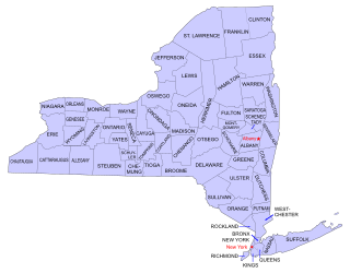
Buildings, sites, districts, and objects in New York listed on the National Register of Historic Places:

Ohio Drive is a street in Southwest Washington, D.C., located in East and West Potomac Parks and bordering the Tidal Basin, Washington Channel, and the Potomac River. It is a central organizing feature of East Potomac Park, providing the only major vehicular route to and through the area. Unlike most roadways named after states in the District of Columbia, Ohio Drive is not an avenue, nor it is heavily used like Wisconsin or Rhode Island Avenues. However, the segment from Independence Avenue to the Rock Creek and Potomac Parkway is an important commuter route.
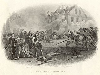
The Colonial Germantown Historic District is a designated National Historic Landmark District in the Germantown and Mount Airy neighborhoods of Philadelphia, Pennsylvania along both sides of Germantown Avenue. This road followed a Native American path from the Delaware River just north of Old City Philadelphia, through Germantown, about 6 miles northwest of Center City Philadelphia, and on to Pottstown. Settlement in the Germantown area began, at the invitation of William Penn, in 1683 by Nederlanders and Germans under the leadership of Francis Daniel Pastorius fleeing religious persecution.
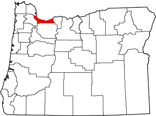
The following list presents the full set of National Register of Historic Places listings in Multnomah County, Oregon. However, please see separate articles for listings in each of Portland's six quadrants.

The Administration Building, Carnegie Institute of Washington is a Beaux-Arts style building designed by architects Carrere and Hastings, and located at 1530 P Street NW in Washington, D.C. It houses the Carnegie Institution for Science, a philanthropic scientific research organization founded in 1902 by Andrew Carnegie. In recognition of the building's architecture and its unique tenant, the building was declared a National Historic Landmark in 1965. The building was also designated a contributing property to the Sixteenth Street Historic District in 1978.

The Robert Simpson Woodward House is a former residence located at 1513 16th Street, NW in the Dupont Circle neighborhood of Washington, D.C. From 1904 until 1914, it was a home of geologist Robert Simpson Woodward (1849–1924), the first president of the Carnegie Institution and a highly regarded scientist and science administrator. The building currently serves as the Capital Research Center headquarters. It was declared a National Historic Landmark in 1976 and designated a contributing property to the Sixteenth Street Historic District in 1978.

The Daniel Webster Memorial is a monument in Washington, D.C. honoring U.S. statesman Daniel Webster. It is located near Webster's former home at 1603 Massachusetts Avenue Northwest, beside Scott Circle at the intersection of Massachusetts Avenue and Rhode Island Avenue.

The Strivers' Section Historic District is a historic district located in the Dupont Circle neighborhood of Washington, D.C. Strivers' Section was historically an enclave of upper-middle-class African Americans, often community leaders, in the late 19th and early 20th centuries. It takes its name from a turn-of-the-20th-century writer who described the district as "the Striver's section, a community of Negro aristocracy." The name echoes that of Strivers' Row in Harlem, a New York City historic neighborhood of black professionals. The district is roughly bounded by Swann Street and the Dupont Circle Historic District on the south, Florida Avenue and the Washington Heights Historic District on the north and west, and the Sixteenth Street Historic District on the east.

Downtown Columbia is the central business, government, and social core of Columbia, Missouri and the Columbia Metropolitan Area. Three colleges — the University of Missouri, Stephens College, and Columbia College — all border the area. Downtown Columbia is an area of approximately one square mile surrounded by the University of Missouri on the south, Stephens College to the east, and Columbia College on the north. The area serves as Columbia's financial and business district and is the topic of a large initiative to draw tourism, which includes plans to capitalize on the area's historic architecture and Bohemian characteristics. The downtown skyline is relatively low and is dominated by the 10-story Tiger Hotel, built in 1928, and the 15-story Paquin Tower.

The 2225 N Street Apartment Building in the West End neighborhood of Northwest Washington, D.C., was constructed in 1924 by local real estate developers Harry Wardman and Eugene Waggaman. The building was added to the District of Columbia Inventory of Historic Sites in 1990 and the National Register of Historic Places in 1994.
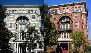
The Gladstone and Hawarden Apartment Buildings are historic twin buildings located in the Logan Circle neighborhood of Washington, D.C. Built in 1900 and 1901, the Gladstone and Hawarden are early examples of middle class apartment buildings in the city. They were designed in the Romanesque Revival architectural style by prominent local architect George S. Cooper. The buildings, since converted into condominiums and a housing cooperative, were added to the National Register of Historic Places (NRHP) in 1994.

Guglielmo Marconi is a public artwork by Attilio Piccirilli, located at the intersection of 16th and Lamont Streets, N.W., in the Mount Pleasant neighborhood of Washington, D.C., United States. It stands as a tribute to Italian inventor Guglielmo Marconi. It was paid for by public subscription and erected in 1941. The artwork was listed on both the District of Columbia Inventory of Historic Sites and the National Register of Historic Places in 2007. It is a contributing property in the Mount Pleasant Historic District. The monument was originally surveyed as part of the Smithsonian's Save Outdoor Sculpture! survey in 1994.

Olympia Apartments is an historic structure located in the Columbia Heights neighborhood in Washington, D.C.'s Northwest Quadrant. Albert B. Morgan designed this apartment building and it was completed in 1898.

Engine Company 23 is a fire station and a historic structure located in the Foggy Bottom neighborhood of Washington, D.C. The two-story Italianate style building was a collaboration of the Washington, D.C. architectural firm of Hornblower & Marshall and District of Columbia Municipal Architect Snowden Ashford. It was built in 1910. The exterior of the structure features segmental-arched vehicle openings and quoined limestone frontispiece. It was listed on both the District of Columbia Inventory of Historic Sites in 2005 and on the National Register of Historic Places in 2007. The building sits on the campus of the George Washington University near Kogan Plaza.

St. Mary Historic District is a national historic district located at Lafayette, Tippecanoe County, Indiana. In 1864, St. Mary's Catholic Church relocated from its original site at Fifth and Brown Streets to Columbia Street. With the move, many of the congregation also moved to this area. The Church became both a religious and social center for the neighborhood. Many of the homes date from the 1860s and 1870s and include fine examples of the Italianate, Greek Revival and Queen Anne styles as well as vernacular house types. Most of the people who built in this area were Lafayette businessmen. At 1202 Columbia Street James Ball, a local wholesale grocer left his name stamped into the front steps. Across the street is the James H. Ward House, who along with his brother, William, owned a local carpet and wallpaper business.
Albert L. Harris was an American architect who worked primarily in Washington, D.C. He was born in Wales and emigrated to the United States as a young child. He worked for architectural firms in Chicago and Baltimore and then Washington, where he also obtained an architectural degree from George Washington University. He was a part-time professor there while also working for the US Navy and then the city of Washington where he served as the city's Municipal Architect from 1921 until his death in 1933. A number of his works are listed on the National Register of Historic Places (NRHP).
The District of Columbia Inventory of Historic Sites is a register of historic places in Washington, D.C. that are designated by the District of Columbia Historic Preservation Review Board (HPRB), a component of the District of Columbia Government.

