Frazeysburg, Ohio

Last updated

Frazeysburg, Ohio
Third west of State, Frazeysburg.jpg
Third Street
OHMap-doton-Frazeysburg.png
Location of Frazeysburg, Ohio
Map of Muskingum County Ohio Highlighting Frazeysburg Village.png
Location of Frazeysburg in Muskingum County
Coordinates: 40°07′20″N82°07′25″W / 40.12222°N 82.12361°W / 40.12222; -82.12361
Country United States
State Ohio
County Muskingum
Township Jackson
Area
[1]
  Total1.03 sq mi (2.66 km2)
  Land1.03 sq mi (2.66 km2)
  Water0.00 sq mi (0.00 km2)
Elevation
[2]
761 ft (232 m)
Population
 (2020)
  Total1,354
  Density1,318.40/sq mi (509.18/km2)
Time zone UTC-5 (Eastern (EST))
  Summer (DST) UTC-4 (EDT)
ZIP code
43822
Area code 740
FIPS code 39-28574 [3]
GNIS feature ID2398920 [2]
Website www.frazeysburg.us

Frazeysburg is a village in Muskingum County, Ohio, United States, along Wakatomika Creek. The population was 1,354 at the 2020 census. It is part of the Zanesville micropolitan area. Frazeysburg is home to the world's largest apple basket, which is located on the Longaberger homestead. [4]

Contents

History

Frazeysburg was originally called Knoxville, and under the latter name was laid out in 1827. [5] The town site was sold in 1828 to Samuel Frazey, and named for him. [5] A post office called Frazeysburg has been in operation since 1837. [6] The village was incorporated in 1868. [7]

Geography

According to the United States Census Bureau, the village has a total area of 0.92 square miles (2.38 km2), all land. [8]

Demographics

Historical population
CensusPop.Note
1870 325
1880 48448.9%
1890 61026.0%
1900 73019.7%
1910 614−15.9%
1920 6678.6%
1930 6791.8%
1940 640−5.7%
1950 6897.7%
1960 84222.2%
1970 94111.8%
1980 1,0258.9%
1990 1,16513.7%
2000 1,2013.1%
2010 1,32610.4%
2020 1,3542.1%
U.S. Decennial Census [9]

2010 census

As of the census [10] of 2010, there were 1,326 people, 525 households, and 369 families living in the village. The population density was 1,441.3 inhabitants per square mile (556.5/km2). There were 592 housing units at an average density of 643.5 per square mile (248.5/km2). The racial makeup of the village was 97.6% White, 0.1% African American, 0.2% Native American, 0.3% Asian, 0.2% from other races, and 1.7% from two or more races. Hispanic or Latino of any race were 0.5% of the population.

There were 525 households, of which 36.6% had children under the age of 18 living with them, 46.7% were married couples living together, 16.6% had a female householder with no husband present, 7.0% had a male householder with no wife present, and 29.7% were non-families. 23.0% of all households were made up of individuals, and 10.5% had someone living alone who was 65 years of age or older. The average household size was 2.53 and the average family size was 2.91.

The median age in the village was 35.4 years. 27.5% of residents were under the age of 18; 7.1% were between the ages of 18 and 24; 27.5% were from 25 to 44; 24.2% were from 45 to 64; and 13.7% were 65 years of age or older. The gender makeup of the village was 47.7% male and 52.3% female.

2000 census

As of the census [3] of 2000, there were 1,201 people, 489 households, and 328 families living in the village. The population density was 1,579.4 inhabitants per square mile (609.8/km2). There were 525 housing units at an average density of 690.4 per square mile (266.6/km2). The racial makeup of the village was 97.50% White, 1.08% African American, 0.08% Native American, 0.33% Asian, 0.08% from other races, and 0.92% from two or more races. Hispanic or Latino of any race were 0.50% of the population.

There were 489 households, out of which 37.0% had children under the age of 18 living with them, 48.7% were married couples living together, 13.3% had a female householder with no husband present, and 32.9% were non-families. 29.2% of all households were made up of individuals, and 11.5% had someone living alone who was 65 years of age or older. The average household size was 2.46 and the average family size was 3.05.

In the village, the population was spread out, with 29.0% under the age of 18, 9.8% from 18 to 24, 30.0% from 25 to 44, 19.9% from 45 to 64, and 11.3% who were 65 years of age or older. The median age was 32 years. For every 100 females there were 85.3 males. For every 100 females age 18 and over, there were 83.0 males.

The median income for a household in the village was $34,545, and the median income for a family was $39,044. Males had a median income of $30,119 versus $21,053 for females. The per capita income for the village was $15,789. About 2.8% of families and 6.6% of the population were below the poverty line, including 5.6% of those under age 18 and 15.1% of those age 65 or over.

Education

Frazeysburg is located in the Tri-Valley Local School District, with children attending school in Frazeysburg for grade school and schools in Dresden for intermediate and high school.

The original Frazeysburg High School building was built in the early 1900s, with the sports teams known as the Red Raiders (thus the reason state route 16 in northwest Muskingum County is named Raiders Road). The school was renamed Frazeysburg-Nashport High School after the closure of Nashport High School due to the creation of Dillon Lake. In 1966, Frazeysburg-Nashport High School merged with Jefferson High School and Adamsville High School to form Tri-Valley High School, which was constructed in Dresden. The old high school building in Frazeysburg then served many years as a junior high school for students from Nashport, Frazeysburg, and Dresden. It then served as an Intermediate School, containing fifth and sixth graders. The old high school was torn down in August 2008, with a time capsule being discovered in the building.

Local government

Gerald Howard was elected as the Mayor of the Village. Kimberly Baldwin, George R. Haines, Robert Hindel, Matthew Mihalko, II, Terry Swartz and Fred Wolford are members of village council. A Board of Trustees of Public Affairs includes Kenneth Jenkins, Dave Ludinich and Carol Cochran Ross of the village.

Community organizations

The Frazeysburg Revitalization Association, founded in 1999, is composed of members who seek to revitalize the community through beautification projects, creation and expansion of community venues such as the new Frew Memorial Park and growth of the local economy through the promotion of new businesses into the area. The association sponsored the creation of the Frew Memorial Park Board, to oversee the creation of Frew Memorial Park. The association has also sponsored the creation of the Frazeysburg Community Center Committee to oversee the transformation of the old Frazeysburg Elementary School into a Community and Business Center. The Community Center opened at the beginning of September 2008 and closed in September 2012 due to lack of funds to heat the building. The community center contained the Frazeyburg Library - which was an all volunteer effort.

Notable people

Related Research Articles

<span class="mw-page-title-main">Perry County, Ohio</span> County in Ohio, United States

Perry County is a county located in the U.S. state of Ohio. As of the 2020 census, the population was 35,408. Its county seat is New Lexington. It was established on March 1, 1818, from parts of Fairfield, Washington and Muskingum counties. The county is named for Oliver Hazard Perry, a hero of the War of 1812. Perry County is included in the Columbus, OH Metropolitan Statistical Area. One of the poorest counties in the state, this is where the lawsuit challenging Ohio's school funding system, DeRolph v. State, began.

<span class="mw-page-title-main">Muskingum County, Ohio</span> County in Ohio, United States

Muskingum County is a county located in the U.S. state of Ohio. As of the 2020 census, the population was 86,410. Its county seat is Zanesville. Nearly bisected by the Muskingum River, the county name is based on a Delaware American Indian word translated as "town by the river" or "elk's eye".

<span class="mw-page-title-main">Twin Oaks, Missouri</span> City in Missouri, United States

Twin Oaks is a 4th class city in St. Louis County, Missouri, United States. The former Village of Twin Oaks changed its status to that of a city by public election in November 2016. The population was 392 at the 2010 census.

<span class="mw-page-title-main">Rock Creek, Ohio</span> Village in Ohio, United States

Rock Creek is a village in Ashtabula County, Ohio, United States. The population was 667 at the 2020 census. It is part of the Ashtabula micropolitan area, 45 miles (72 km) northeast of Cleveland.

<span class="mw-page-title-main">Conesville, Ohio</span> Village in Ohio, United States

Conesville is a village in Coshocton County, Ohio, United States, along the Muskingum River. The population was 328 at the 2020 census.

<span class="mw-page-title-main">Metamora, Ohio</span> Village in Ohio, United States

Metamora is a village in Fulton County, Ohio, United States. The population was 566 at the 2020 census.

<span class="mw-page-title-main">McConnelsville, Ohio</span> Village in Ohio, United States

McConnelsville is a village in and the county seat of Morgan County, Ohio, United States, on the east bank of the Muskingum River. Located 21 miles (34 km) southeast of Zanesville and 26 miles (42 km) northwest of Marietta, the population was 1,667 at the 2020 census.

<span class="mw-page-title-main">Adamsville, Ohio</span> Village in Ohio, United States

Adamsville is a village in Muskingum County, Ohio, United States. The population was 140 at the 2020 census. It is part of the Zanesville micropolitan area.

<span class="mw-page-title-main">Fultonham, Ohio</span> Village in Ohio, United States

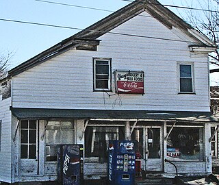
Fultonham is a village in Muskingum County, Ohio, United States. The population was 115 at the 2020 census. It is part of the Zanesville micropolitan area. Fultonham was named for postmaster Robert Fulton.

<span class="mw-page-title-main">New Concord, Ohio</span> Village in Ohio, United States

New Concord is a village in Muskingum County, Ohio, United States. The population was 2,361 as of the 2020 census. It is part of the Zanesville micropolitan area. New Concord is the home of Muskingum University and is served by a branch of the Muskingum County Library System.

<span class="mw-page-title-main">Norwich, Ohio</span> Village in Ohio, United States

Norwich is a village in Muskingum County, Ohio, United States. The population was 87 at the 2020 census. It is part of the Zanesville micropolitan area.

<span class="mw-page-title-main">Philo, Ohio</span> Village in Ohio, United States

Philo is a village in Muskingum County, Ohio, United States, along the Muskingum River. The population was 720 at the 2020 census. It is part of the Zanesville micropolitan area. Philo is the closest municipality to Blue Rock State Park.

<span class="mw-page-title-main">South Zanesville, Ohio</span> Village in Ohio, United States

South Zanesville is a village in Muskingum County, Ohio, United States, along the Muskingum River near the mouth of the Moxahala Creek. The population was 1,894 at the 2020 census. It is part of the Zanesville micropolitan area.

<span class="mw-page-title-main">Bainbridge, Ross County, Ohio</span> Village in Ohio, United States

Bainbridge is a village in Ross County, Ohio, United States, along Paint Creek. The population was 765 at the 2020 census.

<span class="mw-page-title-main">Beverly, Ohio</span> Village in Ohio, United States

Beverly is a village in Washington County, Ohio, United States. The population was 1,233 at the 2020 census. It is part of the Marietta micropolitan area.

<span class="mw-page-title-main">Devola, Ohio</span> CDP in Ohio, United States

Devola is a census-designated place (CDP) in Washington County, Ohio, United States, along the Muskingum River. It is part of the Parkersburg-Marietta-Vienna, WV-OH Metropolitan Statistical Area. The population was 2,639 at the 2020 census.

<span class="mw-page-title-main">Lowell, Ohio</span> Village in Ohio, United States

Lowell is a village in Washington County, Ohio, United States, along the Muskingum River. The population was 549 at the 2020 census. The village is located about 7.6 miles (12.2 km) north of Marietta, Ohio.

<span class="mw-page-title-main">Gratiot, Ohio</span> Village in Ohio, United States

Gratiot is a village in Licking and Muskingum counties in the U.S. state of Ohio. The population was 215 at the 2020 census.

<span class="mw-page-title-main">Roseville, Ohio</span> Village in Ohio, United States

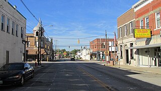
Roseville is a village in Muskingum and Perry counties in the U.S. state of Ohio, along Moxahala Creek. The population was 1,746 at the 2020 census. It is part of the Zanesville micropolitan area. Roseville is served by a branch of the Muskingum County Library System.

<span class="mw-page-title-main">Cross Plains, Wisconsin</span> Village in Wisconsin, United States

Cross Plains is a village in Dane County, Wisconsin, United States. The population was 4,104 at the 2020 census. The village is located partially within the Town of Cross Plains. It is part of the Madison Metropolitan Statistical Area.

References

  1. "ArcGIS REST Services Directory". United States Census Bureau. Retrieved September 20, 2022.
  2. 1 2 U.S. Geological Survey Geographic Names Information System: Frazeysburg, Ohio
  3. 1 2 "U.S. Census website". United States Census Bureau . Retrieved January 31, 2008.
  4. World's Largest Apple Basket
  5. 1 2 Everhart, F.J. (1882). 1794. History of Muskingum County, Ohio, with illustrations and biographical sketches of prominent men and pioneers. F.J. Everhart & Co. p. 478.
  6. "Muskingum County". Jim Forte Postal History. Retrieved January 5, 2016.
  7. Everhart, F.J. (1882). 1794. History of Muskingum County, Ohio, with illustrations and biographical sketches of prominent men and pioneers. F.J. Everhart & Co. p. 479.
  8. "US Gazetteer files 2010". United States Census Bureau . Retrieved January 6, 2013.
  9. "Census of Population and Housing". Census.gov. Retrieved June 4, 2015.
  10. "U.S. Census website". United States Census Bureau . Retrieved January 6, 2013.