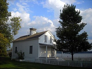
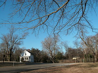
The Jones Point Light is a small river lighthouse located on the Potomac River in Alexandria, Virginia. It was built in 1855. It is a small, one-story house with a lantern on top and served primarily as a warning light for naval ships approaching the Washington Navy Yard. The lighthouse was discontinued in 1926, replaced by a small steel skeletal tower located nearby; this smaller tower was in use for ten years before being discontinued. After being dark for more than half a century, Jones Point Light was relit by a private concern in 1995, however, it was eventually put out again after ownership switched from the Daughters of the American Revolution Foundation to the National Park Service. Certain local efforts have called for the structure to be relit, but as of 2017, the only working lighthouse on the Potomac River is the Fort Washington Point Lighthouse, located five miles downriver.
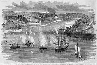
The Battle of Aquia Creek was an exchange of cannon fire between Union Navy gunboats and Confederate shore batteries on the Potomac River at its confluence with Aquia Creek in Stafford County, Virginia. The battle took place from May 29, 1861 to June 1, 1861 during the early days of the American Civil War. The Confederates set up several shore batteries to block Union military and commercial vessels from moving in the Chesapeake Bay and along the lower Potomac River as well as for defensive purposes. The battery at Aquia also was intended to protect the railroad terminal at that location. The Union forces sought to destroy or remove these batteries as part of the effort to blockade Confederate States coastal and Chesapeake Bay ports. The battle was tactically inconclusive. Each side inflicted little damage and no serious casualties on the other. The Union vessels were unable to dislodge the Confederates from their positions or to inflict serious casualties on their garrisons or serious damage to their batteries. The Confederates manning the batteries were unable to inflict serious casualties on the Union sailors or cause serious damage to the Union vessels. Soon after the battle, on Sunday, July 7, 1861, the Confederates first used naval mines, unsuccessfully, off the Aquia Landing batteries. The Confederates ultimately abandoned the batteries on March 9, 1862 as they moved forces to meet the threat created by the Union Army's Peninsula Campaign. The U. S. National Park Service includes this engagement in its list of 384 principal battles of the American Civil War.

The Battle of Cockpit Point, the Battle of Freestone Point, or the Battle of Shipping Point, took place on January 3, 1862, in Prince William County, Virginia, as part of the blockade of the Potomac River during the American Civil War.

Fort Monroe, preserved as the Fort Monroe National Monument, is a decommissioned military installation in Hampton, Virginia, at Old Point Comfort, the southern tip of the Virginia Peninsula, United States. Along with Fort Wool, Fort Monroe originally guarded the navigation channel between the Chesapeake Bay and Hampton Roads—the natural roadstead at the confluence of the Elizabeth, the Nansemond and the James rivers. Until disarmament in 1946, the areas protected by the fort were the entire Chesapeake Bay and Potomac River regions, including the water approaches to the cities of Washington, D.C. and Baltimore, Maryland, along with important shipyards and naval bases in the Hampton Roads area. Surrounded by a moat, the six-sided bastion fort is the largest fort by area ever built in the United States.

Fort Frederick State Park is a public recreation and historic preservation area on the Potomac River surrounding the restored Fort Frederick, a fortification active in the French and Indian War (1754–1763) and the American Revolutionary War (1775-1783). The state park lies south of the town of Big Pool, Maryland. The Chesapeake and Ohio Canal runs through the park grounds. The site was designated a National Historic Landmark in 1973.

Fort Ethan Allen was an earthwork fortification that the Union Army built in 1861 on the property of Gilbert Vanderwerken in Alexandria County, Virginia, as part of the Civil War defenses of Washington. The remains of the fort are now within Arlington County's Fort Ethan Allen Park.

Fort Washington, located near the community of Fort Washington, Maryland, was for many decades the only defensive fort protecting Washington D.C. The original fort, overlooking the Potomac River, was completed in 1809, and was begun as Fort Warburton, but renamed in 1808. During the War of 1812, the fort was destroyed by its own garrison during a British advance.

Fort Mott, located in Pennsville, Salem County, New Jersey, United States, was part of the Harbor Defenses of the Delaware, a three-fort defense system designed for the Delaware River during the postbellum and Endicott program modernization periods following the American Civil War and in the 1890s. The other two forts in the system were Fort Delaware on Pea Patch Island and Fort DuPont in Delaware City, Delaware.
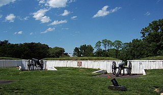
Fort Ward is a former Union Army installation now located in the city of Alexandria in the U.S. state of Virginia. It was the fifth largest fort built to defend Washington, D.C. in the American Civil War. It is currently well-preserved with 90-95% of its earthen walls intact.

Leesylvania State Park is located in the southeastern part of Prince William County, Virginia. The land was donated in 1978 by philanthropist Daniel K. Ludwig, and the park was dedicated in 1985 and opened full-time in 1992.
Possum Point is a small peninsula in Northern Virginia that juts out into Quantico Creek and separates it from the Potomac River. It lies in a suburban area of Washington D.C.
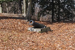
Fort Hunt Park is a public park located in Fort Hunt, Fairfax County, Virginia. It is administered by the National Park Service as part of the George Washington Memorial Parkway. The park preserves the remains of the eponymous Fort Hunt, portions of which date to the time of the Spanish–American War. The park was named after Brigadier General Henry Hunt, who served as chief of artillery of the Army of the Potomac during the Civil War. Remains of several of the fort's original batteries, including Battery Mount Vernon, Battery Robinson, and Battery Sater, and Battery Porter, have been preserved, and may still be visited today. The structures have been stabilized enough that visitors are able to climb on them without difficulty. Besides the batteries, the battery commander's station still stands; in addition, a flagpole has been erected as a memorial to the intelligence officers who served at the fort during World War II.

Westmoreland State Park lies within Westmoreland County, Virginia. The park extends about one and a half miles along the Potomac River. The park covers 1,321 acres. The park's Horsehead Cliffs provide visitors with a panoramic view of the Potomac River. The park offers hiking, camping, cabins, fishing, boating and swimming.
The Potomac Flotilla, or the Potomac Squadron was a unit of the United States Navy created in the early days of the American Civil War to secure Union communications in the Chesapeake Bay, the Potomac River and their tributaries, and to disrupt Confederate communications and shipping in the same.
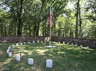
Ball's Bluff Battlefield Regional Park and National Cemetery is a battlefield area and a United States National Cemetery, located 2 miles (3.2 km) northeast of Leesburg, Virginia. The cemetery is the third smallest national cemetery in the United States. Fifty-four Union Army dead from the Battle of Ball's Bluff are interred in 25 graves in the half-acre plot; the identity of all of the interred except for one, James Allen of the 15th Massachusetts, are unknown. Monuments to fallen Confederate Sergeant Clinton Hatcher and Union brigade commander Edward Dickinson Baker are located next to the cemetery, though neither is buried there. While the stone wall-enclosed cemetery itself is managed through the Culpeper National Cemetery and owned by the Department of Veterans Affairs, the balance of the 223-acre (0.90 km2) park is managed through the Northern Virginia Regional Park Authority.

Odiorne Point State Park is a public recreation area located on the Atlantic seacoast in the town of Rye near Portsmouth, New Hampshire. Among the park's features are the Seacoast Science Center and the remains of the World War II Fort Dearborn. The park offers opportunities for hiking, cycling, picnicking, fishing, and boating.

Fort Huger is a historic archaeological site located near Smithfield, Isle of Wight County, Virginia. The site is the location of an abandoned American Civil War fort on the south side of the James River across from Fort Eustis/Mulberry Point. It was named for Major General Benjamin Huger, commander of the Confederate States Army's Department of Norfolk at the time it was built. Fort Huger was an integral part of the Confederate Army's James River defenses in late summer 1861 through spring 1862.

Saltville Battlefields Historic District is a historic American Civil War battlefield and national historic district located around Saltville, in Smyth County and Washington County, Virginia. The district includes 3 contributing buildings, 31 contributing sites, 4 contributing structures, and 1 contributing object near Saltville. It encompass the core areas of two battles, fought on October 2 and December 20, 1864, known as the Battle of Saltville I and Battle of Saltville II, where Confederate and Union forces contested control of the South's most important salt production facilities. Notable resources include the sites of salt furnaces, Well Fields, Fort Statham, Lover's Leap Defenses, Saltville Gap Overlooks, Mill Cliff gun emplacements, Fort Breckinridge, Fort Hatton, Sanders’ House/Williams Site Battlefield/field hospital, William A. Stuart House, and the Elizabeth Cemetery.

Fort Clifton Archeological Site is a historic American Civil War fort archaeological site located at Fort Clifton Park, Colonial Heights, Virginia. The park is the site of Fort Clifton on the Appomattox River where five Union ships sailed on Confederate troops on June 11, 1864. The Confederate Battery, with cannon emplacements, remained in Confederate hands as the cannons drove the Union attackers away. The park has earthworks that criss-cross the property. Fort Clifton Park has hiking trails and Civil War campaign signage on site.
Fort Boykin is a historic site in Isle of Wight County, Virginia, located along the James River. The history of the site is believed to date back to 1623 when colonists were ordered to build a fort to protect them from attacking Native Americans or Spanish marauders. Today the remains of the fort, mostly from the American Civil War, are preserved in a public park.