Fremont, North Carolina | |
---|---|
Coordinates: 35°32′37″N77°58′30″W / 35.54361°N 77.97500°W | |
Country | United States |
State | North Carolina |
County | Wayne |
Area | |
• Total | 1.36 sq mi (3.51 km2) |
• Land | 1.36 sq mi (3.51 km2) |
• Water | 0.00 sq mi (0.00 km2) |
Elevation | 148 ft (45 m) |
Population (2020) | |
• Total | 1,196 |
• Density | 882.01/sq mi (340.49/km2) |
Time zone | UTC-5 (Eastern (EST)) |
• Summer (DST) | UTC-4 (EDT) |
ZIP code | 27830 |
Area code | 919 |
FIPS code | 37-24900 [3] |
GNIS feature ID | 2406524 [2] |
Website | Town of Fremont |
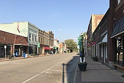
Fremont is a town in Wayne County, North Carolina, United States. The population was 1,255 at the 2010 census. It is included in the Goldsboro, North Carolina Metropolitan Statistical Area.
Originally named Nahunta, it was renamed Fremont in 1869 after Col. Sewall Lawrence Fremont, a former U.S. Army artilleryman and chief engineer of the Wilmington and Wheldon Railroad from 1854 to 1871. [4]
The Aycock Birthplace, Barnes-Hooks Farm, and Dred and Ellen Yelverton House are listed on the National Register of Historic Places. [5]
According to the United States Census Bureau, the town has a total area of 1.4 square miles (3.6 km2), all of it land.
Census | Pop. | Note | %± |
---|---|---|---|
1880 | 246 | — | |
1890 | 377 | 53.3% | |
1900 | 435 | 15.4% | |
1910 | 951 | 118.6% | |
1920 | 1,294 | 36.1% | |
1930 | 1,316 | 1.7% | |
1940 | 1,264 | −4.0% | |
1950 | 1,395 | 10.4% | |
1960 | 1,609 | 15.3% | |
1970 | 1,596 | −0.8% | |
1980 | 1,736 | 8.8% | |
1990 | 1,710 | −1.5% | |
2000 | 1,463 | −14.4% | |
2010 | 1,255 | −14.2% | |
2020 | 1,196 | −4.7% | |
U.S. Decennial Census [6] |
Race | Number | Percentage |
---|---|---|
White (non-Hispanic) | 534 | 44.65% |
Black or African American (non-Hispanic) | 551 | 46.07% |
Asian | 3 | 0.25% |
Other/Mixed | 44 | 3.68% |
Hispanic or Latino | 64 | 5.35% |
As of the 2020 United States census, there were 1,196 people, 426 households, and 212 families residing in the town.
As of the census [3] of 2000, there were 1,463 people, 591 households, and 369 families residing in the town. The population density was 1,074.6 inhabitants per square mile (414.9/km2). There were 671 housing units at an average density of 492.9 per square mile (190.3/km2). The racial makeup of the town was 45.86% White, 50.72% African American, 0.21% Native American, 0.34% Asian, 2.32% from other races, and 0.55% from two or more races. Hispanic or Latino of any race were 2.67% of the population.
There were 591 households, out of which 27.4% had children under the age of 18 living with them, 39.1% were married couples living together, 19.8% had a female householder with no husband present, and 37.4% were non-families. 35.0% of all households were made up of individuals, and 18.6% had someone living alone who was 65 years of age or older. The average household size was 2.39 and the average family size was 3.11.
In the town, the population was spread out, with 25.8% under the age of 18, 6.1% from 18 to 24, 24.0% from 25 to 44, 24.1% from 45 to 64, and 20.0% who were 65 years of age or older. The median age was 41 years. For every 100 females, there were 81.3 males. For every 100 females age 18 and over, there were 77.0 males.
The median income for a household in the town was $25,167, and the median income for a family was $34,375. Males had a median income of $31,250 versus $18,869 for females. The per capita income for the town was $16,892. About 15.6% of families and 21.4% of the population were below the poverty line, including 34.6% of those under age 18 and 17.7% of those age 65 or over.
Education in Fremont is administered by the Wayne County Public Schools system. Schools located in Fremont include Fremont STARS Elementary School, Norwayne Middle School and Charles B. Aycock High School. Higher education is offered through Wayne Community College in Goldsboro.
Wayne County is a county located in the U.S. state of North Carolina. As of the 2020 census, the population was 117,333. Its county seat is Goldsboro, and it is home to Seymour Johnson Air Force Base.
Greene County is a county located in the U.S. state of North Carolina. As of the 2020 census, the population was 20,451. Its county seat is Snow Hill.
Hampton is a town in Calhoun County, Arkansas, United States. The population was 1,181 according to the 2020 United States Census. The town is the county seat of Calhoun County.
Belville is a town in Brunswick County, North Carolina, United States. The population was 1,936 at the 2010 census, up from 285 in 2000. It is part of the Wilmington, NC metropolitan area.
Hookerton is a town in Greene County, North Carolina, United States. The population was 409 at the 2010 census. It is geographically located southeast of Snow Hill on North Carolina Highway 123. The town is part of the Greenville Metropolitan Area.
Snow Hill is a town in Greene County, North Carolina, United States. The population was 1,595 at the 2010 census. It is the county seat of Greene County and is part of the Greenville Metropolitan Area. Snow Hill hosts numerous tennis tournaments during the year. Snow Hill is home to the Green Ridge Racquet Club. Many junior players and adults travel to Snow Hill in order to play in the USTA Sanctioned tournaments.
Walstonburg is a town in Greene County, North Carolina, United States. The population was 219 at the 2010 census. It is located north of Snow Hill on North Carolina Highway 91. The town is part of the Greenville Metropolitan Area.
Weldon is a town in Halifax County, North Carolina, United States. The population was 1,655 at the 2010 census. It is part of the Roanoke Rapids, North Carolina Micropolitan Statistical Area.
La Grange is a town in Lenoir County, North Carolina, United States. The population was 2,873 based on the 2010 census. La Grange is located in North Carolina's Inner Banks region.
Carolina Beach is a beach town in New Hanover County, North Carolina, United States, situated about 12 miles (19 km) south of Wilmington International Airport in southeastern coastal North Carolina. As of the 2020 census, the city population was 6,564. It is part of the Wilmington metropolitan area. The community of Wilmington Beach was annexed by the town in 2000.
Brogden is a census-designated place (CDP) in Wayne County, North Carolina, United States. The population was 2,510 in 2020. It is included in the Goldsboro, North Carolina Metropolitan Statistical Area.
Elroy is a town in Wayne County, North Carolina, United States. In 2007, the estimated population was 3,905. It is included in the Goldsboro, North Carolina Metropolitan Statistical Area.
Eureka is a town in Wayne County, North Carolina, United States. The population was 197 at the 2010 census. It is included in the Goldsboro, North Carolina Metropolitan Statistical Area.
Goldsboro, originally Goldsborough, is a city in and the county seat of Wayne County, North Carolina, United States. The population was 33,657 at the 2020 census. It is the principal city of and is included in the Goldsboro, North Carolina Metropolitan Statistical Area. The nearby town of Waynesboro was founded in 1787, and Goldsboro was incorporated in 1847. It is the county seat of Wayne County.
Mar-Mac is a census-designated place (CDP) in Wayne County, North Carolina, United States. The population was 3,011 at the 2007 census. It is included in the Goldsboro, North Carolina Metropolitan Statistical Area.
Pikeville is a town in Wayne County, North Carolina, United States. The population was 678 at the 2010 census. It is included in the Goldsboro, North Carolina Metropolitan Statistical Area. It is notable for being the home of Collier Motors, an automobile sales and service business established in 1955 that has remained an American Motors (AMC) dealership.
Seven Springs is a town in Wayne County, North Carolina, United States. It lies next to the Neuse River. The 2012 population was estimated at 111. It is included in the Goldsboro, North Carolina Metropolitan Statistical Area.
Walnut Creek is a village in Wayne County, North Carolina, United States. The population was 835 in 2010. It is included in the Goldsboro, North Carolina Metropolitan Statistical Area.
Wallace is a town in Duplin and Pender counties in the U.S. state of North Carolina. The population was 3,883 at the 2020 census. The Pender County portion of Wallace is part of the Wilmington Metropolitan Statistical Area. The town of Wallace was first known as Duplin Crossroads and was incorporated into existence in 1873. Later in 1899, the town fathers decided to adopt the new name, Wallace, to honor Stephen D. Wallace, an official of the Atlantic Coast Line Railroad. Wallace is Duplin County's largest population and retail trade center serving over 50,000 people in a surrounding three county area.
Mount Olive is a town in Duplin and Wayne counties in the U.S. state of North Carolina. The population was 4,589 at the 2010 census. It is included in the Goldsboro, North Carolina Metropolitan Statistical Area. The town is home to the Mt. Olive Pickle Company and the University of Mount Olive.