Jamestown is a town in Newport County, Rhode Island in the United States. The population was 5,559 at the 2020 census. Jamestown is situated almost entirely on Conanicut Island, the second largest island in Narragansett Bay. It also includes the uninhabited Dutch Island and Gould Island.

A Friends meeting house is a meeting house of the Religious Society of Friends (Quakers), where meeting for worship is usually held.

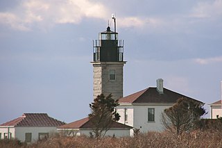
Beavertail Lighthouse was built in 1856 and is the premier lighthouse in Rhode Island, marking the entrance to Narragansett Bay. The 64-foot (20 m) lighthouse lies on the southernmost point of Conanicut Island in the town of Jamestown, Rhode Island in Beavertail State Park, on a site where beacons have stood since the early 18th century. The light provides navigation for boats and ships entering Narragansett Bay in the East Passage between Conanicut Island and Newport, Rhode Island on Aquidneck Island. Other lighthouses are visible from Beavertail Lighthouse, such as Castle Hill Lighthouse, Point Judith Light, and Rose Island Light.

The Benjaminville Friends Meeting House and Burial Ground is a Friends Meeting House of the Religious Society of Friends (Quakers), located north of the rural village of Holder in McLean County, Illinois. It was once the site of a now-defunct village called Benjaminville, founded in 1856 after Quakers settled the area. More Quakers followed, and the burial ground, then the current meeting house in 1874, were constructed. This site, listed on the U.S. National Register of Historic Places since 1983, is all that remains of that village.

Fort Wetherill is a former coast artillery fort that occupies the southern portion of the eastern tip of Conanicut Island in Jamestown, Rhode Island. It sits atop high granite cliffs, overlooking the entrance to Narragansett Bay. Fort Dumpling from the American Revolutionary War occupied the site until it was built over by Fort Wetherill. Wetherill was deactivated and turned over to the State of Rhode Island after World War II and is now operated as Fort Wetherill State Park, a 51-acre (210,000 m2) reservation managed by the Rhode Island Department of Environmental Management.

The Merion Friends Meeting House is an active and historic Quaker meeting house at 615 Montgomery Avenue in Merion Station, Pennsylvania. Completed about 1715, it is the second oldest Friends meeting house in the United States, with distinctively Welsh architectural features that distinguish it from later meeting houses. It is home to the Merion monthly meeting. The meeting house was declared a National Historic Landmark in 1999.

The Old Colony House, also known as Old State House or Newport Colony House, is located at the east end of Washington Square in the city of Newport, Rhode Island, United States. It is a brick Georgian-style building completed in 1741, and was the meeting place for the colonial legislature. From independence in 1776 to the early 20th century, the state legislature alternated its sessions between here and the Rhode Island State House in Providence.

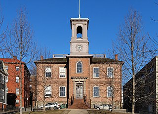
The Old State House on College Hill in Providence, Rhode Island, also known as Providence Sixth District Court House,Providence Colony House, Providence County House, and Rhode Island State House is located on 150 Benefit Street, with the front facade facing North Main Street. It is a brick Georgian-style building largely completed in 1762. It was used as the meeting place for the colonial and state legislatures for 149 years.

The Artillery Park is an historic cemetery at North Road and Narragansett Avenue in Jamestown, Rhode Island. It is located at a high point on the southern part of Conanicut Island. It was originally laid out in 1656 as a burying ground and militia training ground, but appears to have been used as a burying ground only since the 1740s. When British forces occupied the island in 1776, there was a brief skirmish there, and the British afterward used the area as a military staging ground. The cemetery was listed on the National Register of Historic Places in 1973.

Conanicut Island Light, built in 1886, is an inactive lighthouse in Jamestown, Rhode Island.

The Windmill Hill Historic District is a historic district encompassing a large rural landscape in Jamestown, Rhode Island. It is bounded on the north by Eldred Avenue, on the east by East Shore Road, on the south by Great Creek, and on the west by Narragansett Bay. The area's historical resources included six farmsteads, as well as the Quaker Meetinghouse, the Jamestown Windmill, and its associated miller's house and barn. The area is predominantly rolling hills with open pastureland and forest. The district was listed on the National Register of Historic Places in 1978. The area is also rich in prehistoric evidence of Native American occupation, which is the subject of the Jamestown Archeological District listing on the National Register.
The Conanicut Battery is a colonial and 20th century military battery in Jamestown, Rhode Island, west of Beaver Tail Road. The site offers a commanding view of the West Passage of Narragansett Bay.

The Jamestown Windmill is a smock mill in Jamestown, Rhode Island within the Windmill Hill Historic District on North Road north of Weeden Lane.
The Jamestown Archeological District is an expansive archaeological district which is the site of a major prehistoric Native American settlement in Jamestown, Rhode Island. The full extent of archaeologically-sensitive areas has not been fully identified, but is known to extend from Narragansett Avenue in the south to Rhode Island Route 138 in the north, and from Narragansett Bay in the west to North Road. The district overlaps the historically significant Windmill Hill Historic District, and the nearly 300-acre (120 ha) Watson Farm. The district includes one of largest Native American burying grounds in New England, and includes evidence of occupation dating to 3,000 BC.

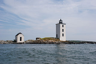
Dutch Island Light is a historic lighthouse on Dutch Island off Jamestown, Rhode Island.

The Portsmouth Friends Meetinghouse, Parsonage, and Cemetery is a historic Friends Meeting House and cemetery of the Religious Society of Friends (Quakers), at 11 Middle Road and 2232 E. Main Road in Portsmouth, Rhode Island.

The East Hoosac Quaker Meetinghouse is a historic Quaker meeting house in Adams, Berkshire County, Massachusetts. The meetinghouse's construction dates to the early 1780s. It now occupies a prominent position within the Maple Street Cemetery, the first burial ground in Adams. Unmarked graves of Adams' early Quaker settlers lie near the meetinghouse, an area now marked by a plaque. The meetinghouse was listed on the National Register of Historic Places in 1976.
This is a list of Registered Historic Places in Jamestown, Rhode Island, which has been transferred from and is an integral part of National Register of Historic Places listings in Newport County, Rhode Island.

The Quaker Meeting House is a historic Quaker meeting house at the intersection of Quakertown Road and White Bridge Road in the Quakertown section of Franklin Township in Hunterdon County, New Jersey. In 1733, Quaker settlers acquired four acres of land here and built a log house for their first meeting house. A stone church was built here in 1754. The current building is a reconstruction built in 1862 using the original stones from that church. It is a key contributing property of the Quakertown Historic District, which was added to the National Register of Historic Places on August 23, 1990. The adjoining burial ground is also contributing to the district. The building is the only Quaker meeting house constructed in Hunterdon County.


