
Mendocino is an unincorporated community in Mendocino County, California, United States. The name comes from Cape Mendocino 85 miles (137 km) to the north, named by early Spanish navigators in honor of Antonio de Mendoza, Viceroy of New Spain. Despite its small size, the town's scenic location on a headland surrounded by the Pacific Ocean has made it extremely popular as an artists' colony and with vacationers.

A shipwreck is the wreckage of a ship that is located either beached on land or sunken to the bottom of a body of water. Shipwrecking may be intentional or unintentional. There were approximately three million shipwrecks worldwide as of January 1999, according to Angela Croome, a science writer and author who specialized in the history of underwater archaeology.
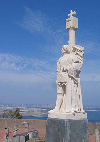
Cabrillo National Monument is a U.S. national monument at the southern tip of the Point Loma peninsula in San Diego, California. It commemorates the landing of Juan Rodríguez Cabrillo at San Diego Bay on September 28, 1542. This event marked the first time a European expedition had set foot on what later became the West Coast of the United States. The site was designated as California Historical Landmark #56 in 1932. The area was listed on the National Register of Historic Places on October 15, 1966.

San Pedro Underwater Archaeological Preserve State Park is a Florida State Park located in 18 feet (5.5 m) of water, approximately 1.25 nautical miles (2.32 km) south of Indian Key. It became the second Florida Underwater Archaeological Preserve when it opened to the public in 1989. The heart of the park is the San Pedro, a submerged shipwreck from a 1733 Spanish flotilla, around which visitors can dive and snorkel. The San Pedro, a 287-ton Dutch-built vessel, and 21 other Spanish ships under the command of Rodrigo de Torres left Havana, Cuba, on Friday, July 13, 1733, bound for Spain. The San Pedro carried a cargo of 16,000 silver Mexican pesos and crates of Chinese porcelain. A hurricane struck the fleet, while entering the Straits of Florida, and sank or swamped most of the fleet. The wrecksite includes an "eighteenth century anchor, replica cannons, ballast stones encrusted with coral, a dedication plaque, and a mooring buoy system." The wreck was added to the U.S. National Register of Historic Places on May 31, 2001.

The original Point Loma Lighthouse is a historic lighthouse located on the Point Loma peninsula at the mouth of San Diego Bay in San Diego, California. It is situated within Cabrillo National Monument. It is no longer in operation as a lighthouse but is open to the public as a museum. It is sometimes erroneously called the "Old Spanish Lighthouse", but in fact it was not built during San Diego's Spanish or Mexican eras; it was built in 1855 by the United States government after California's admission as a state.

Point Cabrillo Light is a lighthouse in northern California, United States, between Point Arena and Cape Mendocino, just south of the community of Caspar. It has been a federal aid to navigation since 1909. It is part of the California state park system as Point Cabrillo Light Station State Historic Park.

USS Puritan, a civilian transport built by Craig Shipbuilding Company in Toledo, Ohio, was launched in 1901, and lengthened by 26 ft (7.9 m) in 1908. The ship sailed on the Great Lakes in passenger service, was purchased by the U.S. Navy at the end of the war, and returned to passenger service after the war. The ship sank in 1933 near Isle Royale in Lake Superior, and its wreck is listed on the National Register of Historic Places.

Sambro Island Lighthouse is a landfall lighthouse located at the entrance to Halifax Harbour, Nova Scotia, on an island near the community of Sambro in the Halifax Regional Municipality. It is the oldest surviving lighthouse in North America and its construction is a National Historic Event.

USS Peterhoff was a British ship captured by the Union Navy during the American Civil War. Condemned as a blockade runner, she served the Union Navy's struggle against the Confederate States of America as a gunboat.
Samuel P. Ely is a shipwreck in Two Harbors, Minnesota listed on the National Register of Historic Places. It was a schooner that sailed the Great Lakes carrying iron ore, coal, and other bulk freight. It was built in 1869 and was a fairly typical example of the 200-foot schooner built in the 1870s, though she was reinforced for the demands of carrying iron ore.

The Cumberland was a wooden-hulled side paddlewheeler built in 1871; it was wrecked off the shore of Isle Royale in Lake Superior in 1877 and the remains are still on the lake bottom. The wreck was placed on the National Register of Historic Places in 1984.

The Penobscot Expedition Site is a submerged historic archaeological area in the waters of the Penobscot River between Bangor and Brewer, Maine. The area is the site of the abandonment and loss of many vessels in the disastrous 1779 Penobscot Expedition, an American Revolutionary War expedition in which the rebellious Americans lost an entire fleet of ships. The site was listed on the National Register of Historic Places in 1973; it has been of interest to salvagers and later archaeologists since the early 19th century.
The Phoenix was a sidewheel paddle steamer operating on Lake Champlain between the United States states of New York and Vermont, and the British province of Lower Canada. Built in 1815, she grounded, burned and sank in 1819 off the shore of Colchester, Vermont. Her surviving wreckage is the oldest known example of a sidewheel steamer anywhere in the world. The wreck site is a Vermont State Historic Site, which may be visited by registered and qualified divers. It was listed on the National Register of Historic Places in 1998.

Grecian was a steel bulk freighter built in 1891 by Globe Iron Works at Cleveland, Ohio. She was a sister ship to Norman, also wrecked nearby. The ship was 296 feet (90 m) long, with a beam of 40 feet (12 m) and a gross register tonnage of 2,348 tons.

The SS Lakeland was an early steel-hulled Great Lakes freighter that sank on December 3, 1924, into 205 feet (62 m) of water on Lake Michigan near Sturgeon Bay, Door County, Wisconsin, United States, after she sprang a leak. On July 7, 2015, the wreck of the Lakeland was added to the National Register of Historic Places.
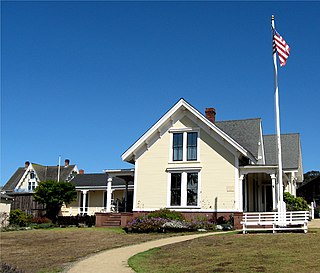
The Kelley House Museum is a house museum in Mendocino, California. It is located at 45007 Albion Street in Mendocino.
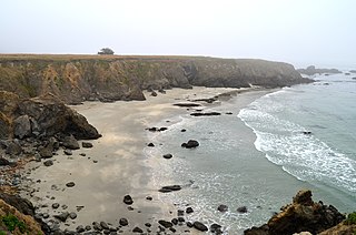
Point Cabrillo is a sandstone headland on the Pacific Ocean coast of Mendocino County, California, between the towns of Mendocino, California and Fort Bragg, California. It is the location of the Point Cabrillo Light. Geography-wise, it lies between Point Arena headland/peninsula to the south, and Cape Mendocino, to the north.


