Geology of Skye

Last updated
Geological map of Skye Skye Geology.png
Geological map of Skye
Basal quartzite of the Eriboll Group from the Ord Window Quartzite outcrop - geograph.org.uk - 901061.jpg
Basal quartzite of the Eriboll Group from the Ord Window
Durness Group dolomites forming a limestone pavement on Bheinn Shuardail Limestone pavement on Bheinn Shuardail - geograph.org.uk - 2929724.jpg
Durness Group dolomites forming a limestone pavement on Bheinn Shuardail
Cross-bedded Jurassic sandstones of the Bearreraig Sandstone Formation near Glasnakille, Strathaird Perforated headland below Glasnakille - geograph.org.uk - 2542017.jpg
Cross-bedded Jurassic sandstones of the Bearreraig Sandstone Formation near Glasnakille, Strathaird
MacLeod's Tables, flat-topped hills and stepped topography from erosion of Paleocene lavas, Duirinish peninsula Uiginish, Skye - geograph.org.uk - 61289.jpg
MacLeod's Tables, flat-topped hills and stepped topography from erosion of Paleocene lavas, Duirinish peninsula
Mafic dyke near Broadford cutting Durness Group dolomite Dyke exposed by the Allt Beinn Deirge - geograph.org.uk - 2481676.jpg
Mafic dyke near Broadford cutting Durness Group dolomite
The Kilt Rock with a columnar jointed dolerite sill above Jurassic sandstones of the Valtos Sandstone Formation Kilt Rock2jpg.jpg
The Kilt Rock with a columnar jointed dolerite sill above Jurassic sandstones of the Valtos Sandstone Formation

The geology of Skye in Scotland is highly varied and the island's landscape reflects changes in the underlying nature of the rocks. A wide range of rock types are exposed on the island, sedimentary, metamorphic and igneous, ranging in age from the Archaean through to the Quaternary.

Contents

Precambrian

The oldest rocks found on Skye are gneisses of the Lewisian complex that were formed about 2,800 million years ago during the Archaean. [1] These gneisses outcrop on the southeastern coast of the Sleat peninsula and were originally granitic igneous rocks. Near Tarskavaig, Neoproterozoic metasediments of the Moine Supergroup are found above strongly deformed Lewisian rocks. The Lewisian and Moine sequences are thrust over another sequence of unmetamorphosed Neoproterozoic sediments, the Torridonian, along the Moine Thrust Zone. The Torridonian on Skye comprises two conformable sequences, the older Sleat Group and the younger Torridon Group. Both groups consist dominantly of sandstones and were deposited mainly by alluvial fans and rivers.

Lower Palaeozoic

A sequence of Cambrian to Lower Ordovician sediments of the Eriboll and Durness Groups lie above the Torridonian with an angular unconformity. The Lower Cambrian Eriboll Group comprises a basal quartzite, locally with a basal conglomerate, followed by the distinctive Pipe Rock Member, a quartz arenite with white weathering skolithos trace fossils. The Pipe Rock is overlain by the Salterella Grit, a coarse sandstone, and the Fucoid Beds, a sequence of calcareous sandstone and siltstone. The overlying Durness Group comprises a series of dolomites of Upper Cambrian to Middle Ordovician in age. The lowest unit is the Ghrudaidh Formation, followed by the Eliean Dubh Formation the Sailmhor Formation and the Sangomore Formation, all consisting of dolomites with chert. The two main exposures of Cambro-Ordovician sediments are the "Ord Window" (a gap in the Kishorn Thrust sheet through which the sequence beneath the thrust can be seen) on the northern coast of Sleat and the area between Broadford and Loch Slapin. These beds are affected by thrusting in both areas and by contact metamorphism from Palaeogene granite intrusions in the northern outcrop, locally forming marble, such as at Torrin. [1]

Mesozoic

Sedimentary rocks of Mesozoic age underlie most parts of the island north of the Sleat Peninsula. They are hidden beneath Palaeogene volcanic rocks over most of this area, being exposed only on the eastern and northern coasts of the Trotternish peninsula, on the Strathaird peninsula and between the Red Hills and Sleat. [1] Triassic rocks of the Stornoway Formation are found near Broadford, a sequence of sandstones and conglomerates deposited by rivers. These beds are overlain by the lower Jurassic Lias Group with the Broadford Beds at the base, passing up into the Pabay Shale Formation, the Scalpay Sandstone Formation the Portree Shale Formation and the Raasay Ironstone Formation. The sequence continues with the Lower to Middle Jurassic Bearreraig Sandstone Formation followed by Middle Jurassic Great Estuarine Group, comprising the Cullaidh Shale Formation, Elgol Sandstone Formation, Lealt Shale Formation, Valtos Sandstone Formation, Duntulm Formation, Kilmaluag Formation and the Skudiburgh Formation. The Upper Jurassic is represented by the Staffin Shale Formation. The only Cretaceous unit exposed on Skye is the Strathaird Limestone Formation, thought to be either Turonian or Campanian in age, which lies unconformably on the Jurassic and is overlain unconformably by Palaeocene lavas. [2]

Paleogene

During the Paleocene to Early Eocene Skye formed one of the main volcanic centres of the North Atlantic Igneous Province. Gently dipping lavas from the volcanoes cover most of northern Skye, giving a stepped trap type landscape. [1] The dominant lava type is basalt, with subsidiary hawaiite and mugearite derived from silica-poor magma and minor amounts of trachyte from a silica-rich magma. Part of the magma chambers for the volcanoes are exposed at the surface as major intrusions of gabbro and granite. These coarse-grained igneous rocks are relatively resistant to erosion and now form the Cuillin hills. The Black Cuillin are formed of gabbro, which erodes to form the characteristically jagged outlines, although this is in large part due to the many minor intrusions, such as dykes and cone sheets that cut the gabbro. [1] The Red Hills are formed of granite and have a more rounded topography. All pre-Quaternary rock types on the island are affected by a major swarm of dykes, which forms part of the North Britain Palaeogene Dyke Suite. Most of the dykes are basaltic in composition but a minority are trachytic. The dominant trend of the dykes is northwest-southeast although they are locally in part radial near the old volcanic centre. On the Trotternish peninsula, mafic magma was intruded along the bedding planes of the Jurassic sedimentary rocks beneath the lavas to form sills that are up to 90m thick. They commonly display columnar jointing, such as in the upper part of the Kilt Rock at Staffin. [1]

Quaternary

During this period the island was affected by the Quaternary glaciation, with the development of an ice cap centred on the Cuillin and Red Hills. The main ice sheet that flowed westwards from the Scottish mainland was diverted around this upland area. The island is covered by large areas of glacial till, left behind when the ice melted. [1]

Economic geology

Lower Jurassic rocks near Broadford have provided building stone for local use whilst aggregate for road construction is sourced in a Torridonian sandstone quarry near Sconser. Hornfelsed lava has been worked near Sligachan and dolerite quarried from a sill near Invertote for a similar purpose. Sand and gravel have been extracted from the raised beach deposits west of Kyleakin with local use made of gravels from the mouth of the river in Glen Brittle. The Skye Marble Company works the Cambro-Ordovician limestones at Torrin, metamorphosed through contact with the adjacent granite and gabbro intrusions. A former quarry at Strath was linked by tramroad to Broadford where the marble was exported, prior to the quarry's abandonment.

Graphite and coal are also present in small quantities, near Portree and at Loch Sligachan respectively, but neither has been economical to work. Exploratory drilling for oil has taken place within the strata of the Great Estuarine Group in the north. Peat has been worked extensively in the past for domestic fuel and indeed continues to be so in the north on a smaller scale even today. Diatomite was worked at Loch Cuithir prior to 1914, the works being connected by tramway to the coast at Invertote. Its end use was in dynamite manufacture and later as a filter and insulator. [3]

Related Research Articles

Gneiss A common high-grade metamorphic rock

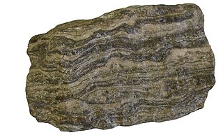
Gneiss is a common and widely distributed type of metamorphic rock. Gneiss is formed by high temperature and high-pressure metamorphic processes acting on formations composed of igneous or sedimentary rocks. Orthogneiss is gneiss derived from igneous rock. Paragneiss is gneiss derived from sedimentary rock. Gneiss forms at higher temperatures and pressures than schist. Gneiss nearly always shows a banded texture characterized by alternating darker and lighter colored bands and without a distinct foliation.

Cuillin mountain range on the Isle of Skye, Scotland

The Cuillin is a range of rocky mountains located on the Isle of Skye in Scotland. The main Cuillin ridge is also known as the Black Cuillin to distinguish it from the Red Cuillin, which lie to the east of Glen Sligachan.

Moine Thrust Belt fault in Highland, Scotland, UK

The Moine Thrust Belt or Moine Thrust Zone is a linear tectonic feature in the Scottish Highlands which runs from Loch Eriboll on the north coast 190 kilometres (120 mi) south-west to the Sleat peninsula on the Isle of Skye. The thrust belt consists of a series of thrust faults that branch off the Moine Thrust itself. Topographically, the belt marks a change from rugged, terraced mountains with steep sides sculptured from weathered igneous, sedimentary and metamorphic rocks in the west to an extensive landscape of rolling hills over a metamorphic rock base to the east. Mountains within the belt display complexly folded and faulted layers and the width of the main part of the zone varies up to 10 kilometres (6.2 mi), although it is significantly wider on Skye.

Geology of Scotland

The geology of Scotland is unusually varied for a country of its size, with a large number of differing geological features. There are three main geographical sub-divisions: the Highlands and Islands is a diverse area which lies to the north and west of the Highland Boundary Fault; the Central Lowlands is a rift valley mainly comprising Palaeozoic formations; and the Southern Uplands, which lie south of the Southern Uplands Fault, are largely composed of Silurian deposits.

Torridon Group

In geology, the term Torridonian is the informal name for the Torridonian Group, a series of Mesoproterozoic to Neoproterozoic arenaceous and argillaceous sedimentary rocks, which occur extensively in the Northwest Highlands of Scotland. The strata of the Torridonian Group are particularly well exposed in the district of upper Loch Torridon, a circumstance which suggested the name Torridon Sandstone, first applied to these rocks by James Nicol. Stratigraphically, they lie unconformably on gneisses of the Lewisian complex and their outcrop extent is restricted to the Hebridean Terrane.

Geology of Jersey

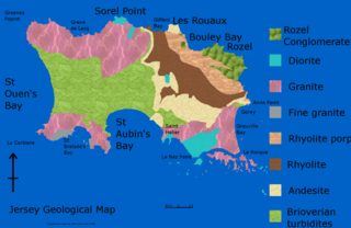
The geology of Jersey is characterised by the Late Proterozoic Brioverian volcanics, the Cadomian Orogeny, and only small signs of later deposits from the Cambrian and Quaternary periods. The kind of rocks go from conglomerate to shale, volcanic, intrusive and plutonic igneous rocks of many compositions, and metamorphic rocks as well, thus including most major types.

Moine Supergroup supergroup in Highland, Scotland, UK

The Moine Supergroup is a sequence of Neoproterozoic metamorphic rocks that form the dominant outcrop of the Scottish Highlands between the Moine Thrust Belt to the northwest and the Great Glen Fault to the southeast. The sequence is metasedimentary in nature and was metamorphosed and deformed in a series of tectonic events during the Late Proterozoic and Early Paleozoic. It takes its name from A' Mhòine, a peat bog in northern Sutherland.

Lewisian complex suite of Precambrian metamorphic rocks that outcrop in the northwestern part of Scotland

The Lewisian complex or Lewisian gneiss is a suite of Precambrian metamorphic rocks that outcrop in the northwestern part of Scotland, forming part of the Hebridean Terrane and the North Atlantic Craton. These rocks are of Archaean and Paleoproterozoic age, ranging from 3.0–1.7 Ga. They form the basement on which the Torridonian and Moine Supergroup sediments were deposited. The Lewisian consists mainly of granitic gneisses with a minor amount of supracrustal rocks. Rocks of the Lewisian complex were caught up in the Caledonian orogeny, appearing in the hanging walls of many of the thrust faults formed during the late stages of this tectonic event.

Hebridean Terrane Part of the Caledonian orogenic belt in northwest Scotland

The Hebridean Terrane is one of the terranes that form part of the Caledonian orogenic belt in northwest Scotland. Its boundary with the neighbouring Northern Highland Terrane is formed by the Moine Thrust Belt. The basement is formed by Archaean and Paleoproterozoic gneisses of the Lewisian complex, unconformably overlain by the Neoproterozoic Torridonian sediments, which in turn are unconformably overlain by a sequence of Cambro–Ordovician sediments. It formed part of the Laurentian foreland during the Caledonian continental collision.

Great Estuarine Group

The Great Estuarine Group is a sequence of rocks which outcrop around the coast of the West Highlands of Scotland. Laid down in the Hebrides Basin during the middle Jurassic, they are the rough time equivalent of the Inferior and Great Oolite Groups found in southern England.

Okavango Dyke Swarm

The Okavango Dyke Swarm is a giant dyke swarm of the Karoo Large Igneous Province in northeast Botswana, southern Africa. It consists of a group of Proterozoic and Jurassic dykes, trending east-southeast across Botswana, spanning a region nearly 2,000 kilometres (1,200 mi) long and 110 kilometres (68 mi) wide. The Jurassic dykes were formed approximately 179 million years ago, composed of mainly tholeiitic mafic rocks. The formation is related to the magmatism at the Karoo triple junction, induced by the plate tectonic break up of the Gondwana supercontinent in the early Jurassic.

The geology of Nigeria formed beginning in the Archean and Proterozoic eons of the Precambrian. The country forms the Nigerian Province and more than half of its surface is igneous and metamorphic crystalline basement rock from the Precambrian. Between 2.9 billion and 500 million years ago, Nigeria was affected by three major orogeny mountain-building events and related igneous intrusions. Following the Pan-African orogeny, in the Cambrian at the time that multi-cellular life proliferated, Nigeria began to experience regional sedimentation and witnessed new igneous intrusions. By the Cretaceous period of the late Mesozoic, massive sedimentation was underway in different basins, due to a large marine transgression. By the Eocene, in the Cenozoic, the region returned to terrestrial conditions.

Geology of Bosnia and Herzegovina

The geology of Bosnia & Herzegovina is the study of rocks, minerals, water, landforms and geologic history in the country. The oldest rocks exposed at or near the surface date to the Paleozoic and the Precambrian geologic history of the region remains poorly understood. Complex assemblages of flysch, ophiolite, mélange and igneous plutons together with thick sedimentary units are a defining characteristic of the Dinaric Alps, also known as the Dinaride Mountains, which dominate much of the country's landscape.

Geology of North Macedonia

The geology of North Macedonia includes the study of rocks dating to the Precambrian and a wide-array of volcanic, sedimentary and metamorphic rocks formed in the last 541 million years.

The geology of Missouri includes deep Precambrian basement rocks formed within the last two billion years and overlain by thick sequences of marine sedimentary rocks, interspersed with igneous rocks by periods of volcanic activity. Missouri is a leading producer of lead from minerals formed in Paleozoic dolomite.

Geology of Uzbekistan

The geology of Uzbekistan consists of two microcontinents and the remnants of oceanic crust, which fused together into a tectonically complex but resource rich land mass during the Paleozoic, before becoming draped in thick, primarily marine sedimentary units.

The geology of Thailand includes deep crystalline metamorphic basement rocks, overlain by extensive sandstone, limestone, turbidites and some volcanic rocks. The region experienced complicated tectonics during the Paleozoic, long-running shallow water conditions and then renewed uplift and erosion in the past several million years ago.

The geology of Israel includes igneous and metamorphic crystalline basement rocks from the Precambrian overlain by a lengthy sequence of sedimentary rocks extending up to the Pleistocene and overlain with alluvium, sand dunes and playa deposits.

The geology of Yukon includes sections of ancient Precambrian Proterozoic rock from the western edge of the proto-North American continent Laurentia, with several different island arc terranes added through the Paleozoic, Mesozoic and Cenozoic, driving volcanism, pluton formation and sedimentation.

The geology of the Isle of Mull in Scotland is dominated by the development during the early Palaeogene period of a ‘volcanic central complex’ associated with the opening of the Atlantic Ocean. The bedrock of the larger part of the island is formed by basalt lava flows ascribed to the Mull Lava Group erupted onto a succession of Mesozoic sedimentary rocks during the Palaeocene epoch.

References

  1. 1 2 3 4 5 6 7 Stephenson, D.; Merritt J. (2006). "Skye: A Landscape Fashioned by Geology" (PDF). Scottish Natural Heritage . Retrieved 20 January 2013.
  2. Hopson, P.M. (2005). "A stratigraphical framework for the Upper Cretaceous Chalk of England and Scotland with statements on the Chalk of Northern Ireland and the UK Offshore Sector" (PDF). Research Report RR/05/01. British Geological Survey . Retrieved 20 January 2013.
  3. Emeleus, C.H.; Bell, B.R. (2005). British Regional Geology: the Palaeogene volcanic districts of Scotland (Fourth ed.). Nottingham: British Geological Survey. p. 171-176. ISBN   0852725191.