Glorieta Sandstone

Last updated
Glorieta Sandstone
Stratigraphic range: Kungurian
Glorieta Sandstone type section.jpg
Glorieta Sandstone type section
Type Formation
Underlies San Andres Formation
Overlies Yeso Group
Thickness81 m (266 ft) (maximum)
Lithology
Primary Sandstone
Location
Coordinates 35°29′38″N105°41′35″W / 35.4938°N 105.6931°W / 35.4938; -105.6931
Region New Mexico
Country United States
Type section
Named for Glorieta Pass
Named by Charles Rollin Keyes
Year defined1915
Glorieta Formation outcrop map.jpg
Red pog.svg
Glorieta Sandstone (New Mexico)

Outcrop map of Glorieta Sandstone in New Mexico with type location indicated

The Glorieta Sandstone is a geologic formation in New Mexico. It preserves fossils characteristic of the Kungurian age of the Permian geology.

Contents

Description

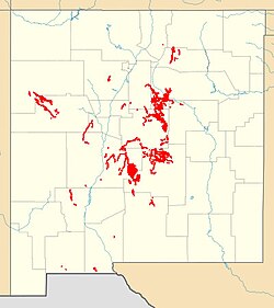
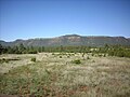
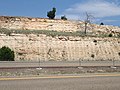
The Glorietta Sandstone is a massive yellowish brown to light gray, cliff-forming, fine to medium grained, very mature quartzarenite sandstone that weathers to reddish brown. [1] [2] At the type section, about 33% of the formation is trough-crossbedded sandstone with beds up to 1.3 metres (4.3 feet) thick and with large foresets. Another 27% of the formation is wind-ripple laminated sandstone. Many beds are extremely well cemented. [2] The formation is exposed in most of the flanking uplifts of the Rio Grande Rift [3] and extends in the subsurface to west Texas. [1] It is particularly prominent in Glorieta Pass but extends west to the Jemez Mountains (where it pinches out in the central Nacimiento Mountains) and south to the Socorro area. [3]

The Glorieta Sandstone is of Kungurian (upper Leonardian) age [4] and forms a ledge at or near the top of the Permian section throughout central New Mexico. It rests conformably on the Yeso Group and is overlain either conformably by thin beds of the San Andres Formation or disconformably with Triassic beds. At the type section at Glorieta Pass, is interpreted as a dune field overlain by eolian sheet deposits. [2] Further south, it shows cross stratification suggesting subaqueous deposition, except for local coastal eolian deposition. [5] The presence of forams and herringbone crossbedding also suggests a shallow marine environment. [2]

The Glorieta Sandstone likely correlates with the Coconino Sandstone of Arizona, from which it was separated by the Defiance Uplift. [6] Detrital zircon geochronology suggests that both formations were derived from deflation of an arid transcontinental river system originating in the Appalachian-Ouachita orogen and Canadian Shield with some local sediment sources in the Ancestral Rocky Mountains. However, the Glorieta Sandstone is thinner, with a maximum thickness of less than 90 meters (300 ft) and dune height of 7 meters (23 ft) versus a thickness of 305 meters (1,001 ft) and dune height of 21 meters (69 ft) for the Coconino Sandstone. The Glorieta Sandstone was deposited by trade winds from the northeast while the Coconino Sandstone was deposited by onshore winds from the north and northwest. Tongues of the Glorieta Sandstone are found up to 150 kilometres (93 mi) southward into the San Andres Formation, and marine carbonate beds within the Glorieta Sandstone record repeated northward marine transgressions. [4]

History of investigation

Keyes first named the formation in 1915, [7] mistaking it for a local tongue of the Dakota Formation. [2] It was long considered either the uppermost member of the Yeso Formation or the lowermost member of the San Andres Formation but was raised to formation rank in 1943. [3]

Footnotes

Related Research Articles

Entrada Sandstone

The Entrada Sandstone is a formation in the San Rafael Group found in the U.S. states of Wyoming, Colorado, northwest New Mexico, northeast Arizona, and southeast Utah. Part of the Colorado Plateau, this formation was deposited during the Jurassic Period sometime between 180 and 140 million years ago in various environments, including tidal mudflats, beaches, and sand dunes. The Middle Jurassic San Rafael Group was dominantly deposited as ergs in a desert environment around the shallow Sundance Sea.

Delaware Basin Geologic depositional and structural basin in West Texas and southern New Mexico, famous for holding large oil fields

The Delaware Basin is a geologic depositional and structural basin in West Texas and southern New Mexico, famous for holding large oil fields and for a fossilized reef exposed at the surface. Guadalupe Mountains National Park and Carlsbad Caverns National Park protect part of the basin. It is part of the larger Permian Basin, itself contained within the Mid-Continent oil province.

Cutler Formation Geologic formation in the Four Corners, US

The Cutler Formation or Cutler Group is a rock unit that is exposed across the U.S. states of Arizona, northwest New Mexico, southeast Utah and southwest Colorado. It was laid down in the Early Permian during the Wolfcampian epoch.

Kaibab Limestone Permian geologic formation

The Kaibab Limestone is a resistant cliff-forming, Permian geologic formation that crops out across the U.S. states of northern Arizona, southern Utah, east central Nevada and southeast California. It is also known as the Kaibab Formation in Arizona, Nevada, and Utah. The Kaibab Limestone forms the rim of the Grand Canyon. In the Big Maria Mountains, California, the Kaibab Limestone is highly metamorphosed and known as the Kaibab Marble.

Coconino Sandstone Geologic formation

Coconino Sandstone is a geologic formation named after its exposure in Coconino County, Arizona. This formation spreads across the Colorado Plateau province of the United States, including northern Arizona, northwest Colorado, Nevada, and Utah.

San Juan Basin

The San Juan Basin is a geologic structural basin located near the Four Corners region of the Southwestern United States. The basin covers 7,500 square miles and resides in northwestern New Mexico, southwestern Colorado, and parts of Utah and Arizona. Specifically, the basin occupies space in the San Juan, Rio Arriba, Sandoval, and McKinley counties in New Mexico, and La Plata and Archuleta counties in Colorado. The basin extends roughly 100 miles (160 km) N-S and 90 miles (140 km) E-W.

Summerville Formation Geologic formation in Four Corners region, US

The Summerville Formation is a geological formation in New Mexico, Colorado, and Utah of the Southwestern United States. It dates back to the Oxfordian stage of the Late Jurassic.

Cedar Mesa Sandstone

Cedar Mesa Sandstone is a sandstone member of the Cutler Formation, found in southeast Utah, southwest Colorado, northwest New Mexico, and northeast Arizona.

San Andres Formation, United States

The San Andres Formation is a geologic formation found in New Mexico and Texas. It contains fossils characteristic of the late Leonardian (Kungurian) Age) of the Permian Period.

Sandia Formation Geologic formation in New Mexico, United States

The Sandia Formation is a geologic formation in New Mexico, United States. Its fossil assemblage is characteristic of the early Pennsylvanian.

El Cobre Canyon Formation Geologic formation in New Mexico, United States

The El Cobre Canyon Formation is a geologic formation in New Mexico. It preserves fossils dating back to the late Pennsylvanian to early Permian periods.

Abo Formation

The Abo Formation is a geologic formation in New Mexico. It contains fossils characteristic of the Cisuralian epoch of the Permian period.

Manzano Group

The Manzano Group is a group of geologic formations in central New Mexico. These have radiometric ages of 1601 to 1662 million years (Ma), corresponding to the late Statherian period of the Paleoproterozoic.

Yeso Group

The Yeso Group is a group of geologic formations in New Mexico. It contains fossils characteristic of the Kungurian Age of the early Permian Period.

Atrasado Formation Geologic formation in New Mexico

The Atrasado Formation is a geologic formation in New Mexico. Its fossil assemblage dates the formation to the Kasimovian age of the Pennsylvanian. It was formerly known locally as the Wild Cow Formation or the Guadelupe Box Formation.

Organ Rock Formation

The Organ Rock Formation or Organ Rock Shale is a formation within the late Pennsylvanian to early Permian Cutler Group and is deposited across southeastern Utah, northwestern New Mexico, and northeastern Arizona. This formation notably outcrops around Canyonlands National Park, Natural Bridges National Monument, and Monument Valley of northeast Arizona, southern Utah. The age of the Organ Rock is constrained to the latter half of the Cisuralian epoch by age dates from overlying and underlying formations. Important early terrestrial vertebrate fossils have been recovered from this formation in northern Arizona, southern Utah, and northern New Mexico. These include the iconic Permian terrestrial fauna: Seymouria, Diadectes, Ophiacodon, and Dimetrodon. The fossil assemblage present suggests arid environmental conditions. This is corroborated with paleoclimate data indicative of global drying throughout the early Permian.

Arroyo del Agua Formation

The Arroyo del Agua Formation is a geologic formation in New Mexico. It preserves fossils dating back to the early Permian period.

Porvenir Formation Geologic formation ion New Mexico, US

The Porvenir Formation is a geologic formation exposed in the southeastern Sangre de Cristo Mountains of New Mexico. It preserves fossils dating back to the middle Pennsylvanian period.

Artesia Group Geologic formation in New Mexico, US

The Artesia Group is a group of geologic formations found in southeastern New Mexico and west Texas. These preserve fossils from the Leonardian to Guadalupian Epochs of the Permian Period.

Victorio Peak Formation

The Victorio Peak Formation is a geologic formation found in the Delaware Basin in Texas and New Mexico. It preserves fossils dating back to the Leonardian Age of the Permian Period.

References