Related Research Articles

The Miami Circle, also known as The Miami River Circle, Brickell Point, or The Miami Circle at Brickell Point Site, is an archaeological site in Brickell, Miami, Florida. It consists of a perfect circle measuring 38 feet (11.5m) of 600 postmolds that contain 24 holes or basins cut into the limestone bedrock, on a coastal spit of land, surrounded by a large number of other 'minor' holes. It is the only known evidence of a prehistoric permanent structure cut into the bedrock in the Eastern United States, and considerably predates other known permanent settlements on the East Coast. It is believed to have been the location of a structure, built by the Tequesta Indians, in what was possibly their capital. Discovered in 1998, the site is believed to be somewhere between 1,700 and 2,000 years old.


The Big Ram Site, designated Site 36.32 by the Maine Archeological Survey, is a prehistoric archaeological site on Ram Island, an island in the Androscoggin River in Turner, Maine. The site, excavated in 1987, yielded ceramic and other artifacts dating to two periods of occupation, c. 100–600 CE, and c. 1400–1700 CE. The site was listed on the National Register of Historic Places in 1992.

Colonial Pemaquid State Historic Site is a publicly owned historic property operated by the state of Maine near Pemaquid Beach in Bristol, Maine. The site includes the reconstructed Fort William Henry, archaeological remains of 17th- and 18th-century village buildings and fortifications, and a museum with artifacts found on the site including musket balls, coins, pottery, and early hardware.
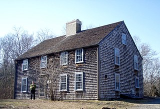
The John and Priscilla Alden Family Sites is a National Historic Landmark consisting of two separate properties in Duxbury, Massachusetts. Both properties are significant for their association with John Alden, one of the settlers of the Plymouth Colony who came to America on board the Mayflower and held numerous posts of importance in the colony. Alden and his relationship with Priscilla Mullins were memorialized by Henry Wadsworth Longfellow in The Courtship of Miles Standish, a fictionalized narrative poem that made the story a piece of American folklore.
The DEDIC or DEDIC/Sugarloaf Site is a paleo-Indian Clovis-era archaeological site in South Deerfield, Massachusetts. It encompasses an area of the Connecticut and Deerfield River valleys containing evidence of relatively large-scale human habitation dating back some 10,000 years. It is located in the general vicinity of Mount Sugarloaf. Part of it is set on the lip of a ravine, apparently a site that the natives used as a kill site, since it served as a choke point in the movements of large animals. It was added to the National Register of Historic Places in 1980.

Franktown Cave is located 25 miles (40 km) south of Denver, Colorado on the north edge of the Palmer Divide. It is the largest rock shelter documented on the Palmer Divide, which contains artifacts from many prehistoric cultures. Prehistoric hunter-gatherers occupied Franktown Cave intermittently for 8,000 years beginning about 6400 BC The site held remarkable lithic and ceramic artifacts, but it is better known for its perishable artifacts, including animal hides, wood, fiber and corn. Material goods were produced for their comfort, task-simplification and religious celebration. There is evidence of the site being a campsite or dwelling as recently as AD 1725.
The Debert Palaeo-Indian Site is located nearly three miles southeast of Debert, Colchester County, Nova Scotia, Canada. The Nova Scotia Museum has listed the site as a Special Place under the Special Places Protection Act. The site acquired its special status when it was discovered as the only and oldest archaeological site in Nova Scotia. The Debert site is significant to North American archaeology because it is the most North-easterly Palaeo-Indian site discovered to date. It also provides evidence for the earliest human settlements in eastern North America, which have been dated to 10,500–11,000 years ago. Additionally, this archaeological site remains one of the few Palaeo-Indian settlements to be identified within the region of North America that was once glaciated.
The Rumford Archaeological Sites are a collection of prehistoric Native American sites in the vicinity of the Androscoggin River near Rumford, Maine. These six sites provide a window of observation into the movements and practices of Native Americans from c. 7,000 BCE to the Late Woodland period and contact with Europeans. These sites are the subject of three separate listings on the National Register of Historic Places in 1972: the Rumford Falls I-IV Sites, the Rumford V Site, and the Town of Rumford Site. The locations of these sensitive sites are not generally publicized.
Ntolonapemk, also known as the Eastern Surplus Company Superfund Site and Maine State Survey No. 96.02, is a prehistoric archaeological site in Meddybemps, a small town in Washington County, Maine. Located near the outlet of Meddybemps Lake, it is one of the only major inland prehistoric habitation sites in the county, with evidence of more than 8,000 years of use. The site was listed on the National Register of Historic Places in 2001.
The Munsungan-Chase Lake Thoroughfare Archeological District encompasses a series of important archaeological sites in a remote area of northern Maine, United States. These sites offer evidence of human habitation dating to not long after the retreat of the glaciers following the Wisconsin glaciation, with extensive stone tool workshops working with red chert found in abundance in the area. Stone tools made from sources in this region have been found at archaeological sites across New England. The district was listed on the National Register of Historic Places in 1979.
The town of North Haven, Maine is an island community located principally on North Fox Island in southern Penobscot Bay, separated from its mouth by Vinalhaven. The Fox Islands were the subject of an intensive archaeological survey in the 1970s, in which more than 49 sites of interest were identified in North Haven. Eight of these were deemed significant enough to be listed on the National Register of Historic Places; the most significant of these, the Turner Farm Site, was a site exhibiting evidence of year-round occupation during at least three time periods in prehistory.
Donald Soctomah is a Native American author, filmmaker, historian, and politician. He serves as the tribal historic preservation officer for the Passamaquoddy tribe, where he works with both the U.S. and Canadian governments on the protection of culturally significant sites, artifacts and knowledge. Soctomah has written several books about Passamaquoddy history, as well as a children's book, Remember Me: Tomah Joseph's Gift to Franklin Delano Roosevelt and The Canoe Maker.
Flye Point 2, also designated Site 42.43 by the Maine Archaeological Survey, is a prehistoric archaeological site in Brooklin, Maine. This site includes a large shell midden, and has yielded evidence of human habitation, including "pit house" features, with an estimated occupation time of 1000 CE. The midden is one of the largest of its type on the coast of eastern Maine. It was listed on the National Register of Historic Places in 1985.
The Devils Head Site, designated Site 97.10 by the Maine Archaeological Survey, is a prehistoric and historic archaeological site in Calais, Maine. Located on the banks of the St. Croix River, it is a shell midden site with evidence of multiple periods of human habitation, from the Middle Ceramic Period to the Late Contact Period and beyond. With its location near Saint Croix Island, the site of an early French settlement in 1604, the site's finds may provide insight into early French-Native relations in the area. The site was listed on the National Register of Historic Places in 2006.
The Brockway Site, designated Site 90.3 by the Maine Archaeological Survey, is a prehistoric archaeological site in Milo, Maine. Long known to local amateur archaeologists, the site was formally tested in 1986, yielding evidence of a well-stratified site containing thousands of artifacts dating as far back as c. 2000 BCE. These types of sites are rare in the interior of Maine. The site was listed on the National Register of Historic Places in 1987.
Archeological Site No. 74-2 is a prehistoric site in Indian Island, Maine. Located on a terrace above the Penobscot River, the site dates to the Middle Archaic Period, a rarity in Maine, made even more unusual by the absence of later period artifacts. The site was listed on the National Register of Historic Places in 1984, for its potential to increase what is known about Native settlement patterns in the area.
The Schilling Archeological District is a prehistoric Native American archaeological site on private property on Lower Grey Cloud Island in Cottage Grove, Minnesota, United States. It consists of a habitation site and mound group with artifacts that date from the Early Woodland Period to the Late Prehistoric Period. It was listed on the National Register of Historic Places in 1978 for having state-level significance in the theme of archaeology. It was nominated for its rare Early Woodland component, Middle Mississippian cultural influences, and potential to show climatic adaptations over time.

The Moccasin Bluff site is an archaeological site located along the Red Bud Trail and the St. Joseph River north of Buchanan, Michigan. It was listed on the National Register of Historic Places in 1977, and has been classified as a multi-component prehistoric site with the major component dating to the Late Woodland/Upper Mississippian period.
The Clampitt site (12Lr329) is a prehistoric archaeological site that sits on a sandy terrace along the East Fork of White River, southeast of Bedford in Lawrence County, Indiana. The site was excavated by the Indiana University archaeological field school in the summers of 1991 and 1992. The Clampitt site was added to the National Register of Historic Places in 2016. The site is located on private property. It is one of thirteen National Register of Historic Places listings in Lawrence County, Indiana.
References
- 1 2 "National Register Information System". National Register of Historic Places . National Park Service. March 13, 2009.
- 1 2 3 Spiess, Arthur (1999). NRHP nomination for Governors Point; redacted version available by request from the National Park Service
| Topics | |
|---|---|
| Lists by state |
|
| Lists by insular areas | |
| Lists by associated state | |
| Other areas | |
| Related | |