Grant Road (Los Alamos, New Mexico)

Last updated
Grant Road
Grant Road, historic wagon trail, New Mexico.jpg
A section of the Grant Road
USA New Mexico location map.svg
Red pog.svg
LocationApprox. 131 ft. N of the NE corner of the jct. of Diamond Dr. and San Ildefonso Rd., Los Alamos, New Mexico
Coordinates 35°53′57″N106°17′54″W / 35.89917°N 106.29833°W / 35.89917; -106.29833 (Grant Road per NRIS)
Arealess than one acre
Builtcirca 1887
Built byAnglo and Hispanic homesteaders
Architectural style3,740-foot long road with one homestead structure
MPS Homestead and Ranch School Era Roads and Trails of Los Alamos, New Mexico MPS
NRHP reference No. 03001409 [1]
Added to NRHPJanuary 14, 2004

The Grant Road in Los Alamos, New Mexico, known today as Dot Grant Trail, and also New Mexico Laboratory of Anthropology Trail # 89103, is a historic wagon road, now a hiking trail, which was listed on the National Register of Historic Places in 2004. [1] The trail was named for Ottie Oman "Dot" Grant, an Anglo homestead owner originally from Colorado who had bought an existing Hispanic homestead to support his agricultural lifestyle year round. [2] [3]

Contents

The Grant historic wagon trail was part of a system of roads and trails used for transportation and horses on the Pajarito Plateau of Northern New Mexico. The terrain is rugged and remote. There were ten historic roads in the area including the Grant Road which served the Grant Farm, and connected with two other major access roads on Pajarito Plateau. [4]

The trail is used now as a hiking and mountain biking trail. The soft tuff underlying the trail is still deeply rutted from years of wagon use. [5]

History

For centuries, the local Indigenous peoples used the Pajarito Plateau as a resource during certain seasons of the year. The earliest evidence that archaeologists have found of use by Paleo-Indians dating back to 9500 BC to 8000 BC, and to the Archaic period (2000 BC to 600 AD). Artifacts such as small stone hearths, knapped stone projectile points, and scatters of Archaic period lithic fragments are evidence that the area had short-term use. Evidence of seasonal use was also found dating between 600 AD and 1150 AD. [4]

Beginning in 1150 AD to 1550 AD the Ancestral Puebloan people and later the Puebloan people occupied the area; there they built modestly sized farmsteads where they practiced agriculture and also hunting and gathering. Larger scale pueblos on Pajarito Plateau. There is no evidence that the Spaniards who arrived in New Mexico in 1592, used the area, nor is there any evidence of use by any other European peoples at the time until the mid-19th century. [4]

In 1846, the United States participated in the Conquest of New Mexico, during the Mexican-American War, which was the start of permanent use of the plateau by settlers. [4] [6] The system of trails and roads in the area were developed more fully between 1887 and 1943 by the local Hispanic and Anglo settlers in the rugged plateau landscape, now known as Los Alamos. The Hispanic homesteaders used these trails and roads seasonally to haul water and products to market, and herd livestock during grazing season. [4]

20th century use

1913 marks the first appearance of Grant Road on a United States Forest Service map. At that time, the road provided a means of approach to Rendija Canyon and Bayo Canyon as well as to the homesteads in the Barranca and North mesa areas in the western lowlands. In 1915, a 24-year old Hispanic homesteader named Ramon Martinez applied for a use-permit to homestead the area for himself, his wife and child to live a life similar to other Hispanic homesteaders. He used the homestead seasonally, returning to the lower altitude valley below in the fall, then moved back up to the homestead each spring. In 1925, Ramon and Adelaida Roybal purchased the homestead from Martinez for $500. Five years later it was sold to Dot Grant for $300 to establish a permanent home. When Ottie Oman "Dot" Grant, an Anglo homestead owner from Colorado bought the existing Hispanic homestead and the associated trail to support his agricultural lifestyle year round (unlike his neighbors who used their land seasonally), the road was a means to provide access to his property. Grant married Emelina Garcia, from the Espanola Valley. He acquired grazing rights, raised cattle and chickens as well as growing a diverse variety of crops. He sold meat, eggs and vegetables to the Los Alamos Ranch School and in the markets of Santa Fe. [3]

The road's first major period of 20th century significance was from 1920-1924, when the Los Alamos Ranch School was first built and the area was used for the training of boys in outdoor skills including maintaining the trails. The most significant year of use of the Grant Road was 1943 for exploration and settlement when the Los Alamos Laboratory was under construction, and continued through the years of the Manhattan Project when the first atomic bomb was being built. Use continued until about 1949. [7] [4] This period abruptly ended the agricultural lifestyle of Ottie Oman "Dot Grant during which all "individual homesteads and homestead access roads were condemned, bringing to a close the rural character and agricultural economy of the area." [3]

The site's 2003-dated National Register nomination document identifies its southern end as being located "Approx. 131 ft. N of the NE corner of the jct. of Diamond Dr. and San Ildefonso Rd." [8] However the roadways and intersection have changed. [9] At the time of the nomination, the homestead road was considered to be "well preserved." [3]

It was entered into the registry of historic places on January 14, 2004. [7] Grant Road is considered to be historically significant at the local level by the NHRP per Criterion A as a settlement and transportation route, and per the Homestead and Ranch School Era Roads and Trails of Los Alamos, New Mexico. [3]

Current use

The road was the access route to a historic homestead located along the trail, the Guaje Pines Cemetery is located near the northern end. Today Grant Road is now used as a recreational hiking trail. [2] [8] It is also used as a mountain biking trail that connects the Perimeter trail to Rendija Canyon and the Cabra Loop trail. [10] Additionally, it can be used as access to the Bayo Canyon Trail, the Bridges Trail and to Three Bears/Guaje Road. The ascent along the trail is 207 feet, and the descent section is -61 feet with a total altitude differential of 146 feet. The trail head begins at 7,115 feet in altitude and the end of the trail is at 7,261 feet. [11]

Trivia

A scene from the 2023 film, Oppenheimer, was filmed on the Dot Grant Trail. [12]

Related Research Articles

<span class="mw-page-title-main">White Rock, New Mexico</span> Census-designated place in New Mexico, United States

White Rock is an unincorporated community and census-designated place (CDP) in Los Alamos County, New Mexico. It is one of two major population centers in the county; the other is Los Alamos. The population was 5,725 at the 2010 census. It is largely a bedroom community for employees of Los Alamos National Laboratory and their families. Access to White Rock from the town of Los Alamos and other cities and towns in New Mexico is via New Mexico State Road 4, which forms the northwestern boundary of the community. Administratively, White Rock is a neighborhood of Los Alamos; locals refer to Los Alamos as "the Townsite," or "the Hill".

<span class="mw-page-title-main">Valles Caldera</span> Volcanic caldera in New Mexico, United States

Valles Caldera is a 13.7-mile (22.0 km) wide volcanic caldera in the Jemez Mountains of northern New Mexico. Hot springs, streams, fumaroles, natural gas seeps and volcanic domes dot the caldera floor landscape. The highest point in the caldera is Redondo Peak, an 11,253-foot (3,430 m) resurgent lava dome located entirely within the caldera. Also within the caldera are several grass valleys, or valles, the largest of which is Valle Grande, the only one accessible by a paved road. In 1975, Valles Caldera was designated as a National Natural Landmark by the National Park Service with much of the caldera being within the Valles Caldera National Preserve, a unit of the National Park System.

<span class="mw-page-title-main">Chatsworth, Los Angeles</span> Neighborhood of Los Angeles in California, United States

Chatsworth is a suburban neighborhood in Los Angeles, California, in the San Fernando Valley.

<span class="mw-page-title-main">Bandelier National Monument</span> United States historic place

Bandelier National Monument is a 33,677-acre (136 km2) United States National Monument near Los Alamos in Sandoval and Los Alamos counties, New Mexico. The monument preserves the homes and territory of the Ancestral Puebloans of a later era in the Southwest. Most of the pueblo structures date to two eras, dating between AD 1150 and 1600.

<span class="mw-page-title-main">Topanga State Park</span> State park in Los Angeles County, California, United States

Topanga State Park is a California state park located in the Santa Monica Mountains, within Los Angeles County, California. It is part of the Santa Monica Mountains National Recreation Area.

<span class="mw-page-title-main">Pajarito Plateau</span>

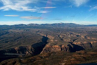
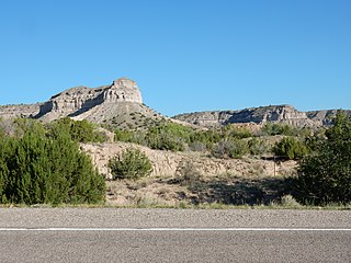
The Pajarito Plateau is a volcanic plateau in north central New Mexico, United States. The plateau, part of the Jemez Mountains, is bounded on the west by the Sierra de los Valles, the range forming the east rim of the Valles Caldera, and on the east by the Puye escarpment, which rises about 300 to 400 feet above the Rio Grande valley about a mile (1.6 km) west of the river. The Rio Grande passes through White Rock Canyon to the southeast, and the Caja del Rio across the river is sometimes regarded as part of the plateau. The plateau is occupied by several notable entities, including Bandelier National Monument, the town of Los Alamos and its remote suburb White Rock, and Los Alamos National Laboratory. Elevations range from about 5,600 feet at the river to about 7,800 feet where the plateau merges into the mountain range.

<span class="mw-page-title-main">Cerro Grande Fire</span> Wildfire in New Mexico, United States

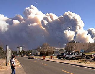
The Cerro Grande Fire was a prescribed forest fire in Los Alamos, New Mexico, United States of America, that occurred in May of 2000. The fire started as a controlled burn, and became uncontrolled owing to high winds and drought conditions. Over 400 families in the town of Los Alamos, New Mexico, lost their homes in the resulting 43,000-acre (170 km2) fire. Structures at Los Alamos National Laboratory were also destroyed or damaged, although without loss or destruction of any of the special nuclear material housed there. No loss of human life occurred. The US General Accounting Office estimated total damages at $1 billion.

<span class="mw-page-title-main">Dome Fire</span> Wildfire in New Mexico, United States

The Dome Fire was a destructive wildfire in the Jemez Mountains in the northern region of the U.S. state of New Mexico during the 1996 fire season. It has been described by forester Bill Armstrong as "a wakeup call that nobody woke up to", anomalous at the time but an indicator of future high-intensity fires that are becoming more common due to both local and global environmental changes.

<span class="mw-page-title-main">La Mesa Fire</span> Wildfire in New Mexico, United States

The La Mesa Fire was a 1977 wildfire on the Pajarito Plateau of New Mexico, in the Southwestern United States.

<span class="mw-page-title-main">Los Alamos Historical Museum</span>

The Los Alamos Historical Museum is housed in the historic Guest House, located next to Fuller Lodge, of Los Alamos Ranch School, which was General Leslie Groves's favorite place to stay during the Manhattan Project.

<span class="mw-page-title-main">New Mexico State Road 502</span> State highway in New Mexico, United States

New Mexico State Road 502 (NM 502) is a 18.301-mile-long (29.453 km) state highway in New Mexico, United States of America. It is notable as the main access route to Los Alamos National Laboratory (LANL), Bandelier National Monument, Valles Caldera National Preserve, Jemez Mountains, and town of Los Alamos.

<span class="mw-page-title-main">Caja del Rio</span> Landform in New Mexico, United States

Caja del Rio is a dissected plateau, of volcanic origin, which covers approximately 84,000 acres of land in northern Santa Fe County, New Mexico, United States. The region is also known as the Caja, Caja del Rio Plateau, and Cerros del Rio. The center of the area is approximately 15 miles (23 km) west of Santa Fe, New Mexico. Most of the Caja is owned by the United States Forest Service and managed by the Santa Fe National Forest. Access is through New Mexico Highway 599, Santa Fe County Road 62, and Forest Service Road 24.

<span class="mw-page-title-main">Los Alamos, New Mexico</span> Census-designated place in New Mexico, United States

Los Alamos is a census-designated place in Los Alamos County, New Mexico, United States, that is recognized as one of the development and creation places of the atomic bomb—the primary objective of the Manhattan Project by Los Alamos National Laboratory during World War II. The town is located on four mesas of the Pajarito Plateau, and had a population of about 13,200 as of 2020. It is the county seat and one of two population centers in the county known as census-designated places (CDPs); the other is White Rock.

<span class="mw-page-title-main">Las Conchas Fire</span> Wildfire in New Mexico, United States

The Las Conchas Fire was a large wildfire in the state of New Mexico, in the United States, in 2011. The fire started in Santa Fe National Forest and burned more than 150,000 acres, threatening Los Alamos National Laboratory and the town of Los Alamos. After five days of burning, it became the largest wildfire in New Mexico state history at the time. It was surpassed in 2012 by the much larger Whitewater-Baldy Complex Fire and in 2022 by the Calf Canyon/Hermits Peak Fire and the Black Fire making the Las Conchas Fire the fourth-largest fire in New Mexico's recorded history.

<span class="mw-page-title-main">Otowi Suspension Bridge</span> Bridge

The Otowi Suspension Bridge, spanning the Rio Grande River near San Ildefonso, New Mexico, is a wooden single-lane suspension bridge for road traffic, built in 1924. It was listed on the National Register of Historic Places in 1997.

Buckman is a ghost town in Santa Fe County, New Mexico, United States of America, about 5 miles (8.0 km) south of San Ildefonso Pueblo, on the east bank of the Rio Grande in White Rock Canyon.

Dwight Smith Young was an American "carpenter, photographer, archaeologist, cook, meteorologist, poet and self-made physicist" who took part in the Manhattan Project. He was given the nickname "The Hermit of Pajarito Canyon" after making his home in an old log cabin in a remote canyon on the Los Alamos testing site from roughly 1946 to 1952.

Bayo Road, in Los Alamos, New Mexico, was listed on the National Register of Historic Places in 2003. It is also known as Bayo Canyon Road.

<span class="mw-page-title-main">Bandelier Tuff</span> A geologic formation in New Mexico

The Bandelier Tuff is a geologic formation exposed in and around the Jemez Mountains of northern New Mexico. It has a radiometric age of 1.85 to 1.25 million years, corresponding to the Pleistocene epoch. The tuff was erupted in a series of at least three caldera eruptions in the central Jemez Mountains.

<span class="mw-page-title-main">Puye Formation</span> A geologic formation in New Mexico

The Puye Formation is a geologic formation exposed east of the Jemez Mountains of northern New Mexico. Radiometric dating constrains its age to between 5 and 2 million years, corresponding to the Pliocene epoch.

References

  1. 1 2 "National Register Information System". National Register of Historic Places . National Park Service. November 2, 2013.
  2. 1 2 "Los Alamos County Trail Network Guide Historic Trails and Roads" (PDF). Visit Los Alamos. Los Alamos. Retrieved 12 May 2024.
  3. 1 2 3 4 5 "Grant Road, New Mexico Laboratory of Anthropology #89103: National Registry of Historical Places". NPGalleryNPS.com. Retrieved 12 May 2024.
  4. 1 2 3 4 5 6 "Homestead and Ranch School Era Roads and Trails of Los Alamos, New Mexico" (PDF). NPS History. National Register of Historic Places. Retrieved 12 May 2024.
  5. "Trail Management Planning Documents" (PDF). LosAlamosNM. Los Alamos County Trail Policy Plan, Department of Community Services, Parks Division. Retrieved 12 May 2024.
  6. Lamar, Howard Roberts (2000). The Far Southwest, 1846–1912: A Territorial History. University of New Mexico Press. ISBN   9780826322487.
  7. 1 2 "Grant Road". National Registry of Historic Places. National Park Service. Retrieved 12 May 2024.
  8. 1 2 Debbie Hoard (November 25, 2003). "National Register of Historic Places Registration: Grant Road / New Mexico Laboratory of Anthropology #89103". National Park Service . Retrieved October 27, 2021. With accompanying two photos from 2002
  9. Compare Google satellite view vs. registration document.
  10. "Dot Grant Trail". Mountain Trail Bike Project. Retrieved 12 May 2024.
  11. "Dot Grant". Trail Forks. Retrieved 12 May 2024.
  12. "Los Alamos: Openheimer Film Tour" (PDF). Visit Los Alamos. Retrieved 12 May 2024.

Further reading

Machen, Judith, McGehee, Ellen D. and Hoard, Dorothy. Homesteading on the Pajarito Plateau, 1887-1942, (2012), published by the Los Alamos National Laboratory