
Hardin County is a county located in the U.S. state of Iowa. As of the 2020 census, the population was 16,878. The county seat is Eldora. The county was named in honor of Col. John J. Hardin, of Illinois, who was killed in the Mexican–American War.

Eldora is a city in Hardin County, Iowa, United States. The population was 2,663 at the time of the 2020 census. It is the county seat of Hardin County.
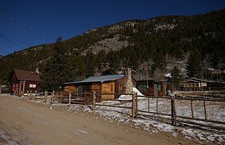
Eldora Historic District is a 30 acres (12 ha) historic district in Eldora, Colorado. Other names of the district and/or other historic names of places in the district are Happy Valley, Eldorado Camp, and 5BL758. It was listed on the National Register of Historic Places in 1989. The listing included 55 contributing buildings and 12 non-contributing ones.

The Iowa Soldiers' Orphans' Home, also known at the Annie Wittenmyer Home or the Annie Wittenmyer Center, located in Davenport, Iowa, United States is a former orphanage for children. It is listed on the Davenport Register of Historic Properties and as a historic district on the National Register of Historic Places. The home was originally used for orphans from the American Civil War. Starting in 1876, children from broken homes, as well as orphans from all of Iowa's 99 counties, were taken in at the home.

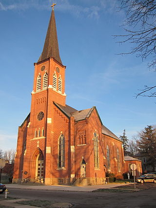
First Congregational Church is a congregation of the United Church of Christ located in Eldora, Iowa, United States. The congregation was organized in 1868 and the church building was individually listed on the National Register of Historic Places in 1996. In 2010 it was included as a contributing property in the Eldora Downtown Historic District in 2010.
The Hardin County Courthouse, located in Eldora, Iowa, United States, was built in 1892. The courthouse is the third building to house court functions and county administration. It was individually listed on the National Register of Historic Places in 1981. In 2010 it was included as a contributing property in the Eldora Downtown Historic District.
The North Main–North Detroit Street Historic District is a historic neighborhood on the northern side of the city of Kenton, Ohio, United States. Important because of its architecture and because of its prominent early residents, it was declared a historic district in 1985.
Secor, previously known as Xenia and Delanti, is a ghost town in Hardin County, Iowa, United States. The community was 3.5 miles (5.6 km) south-southeast of Eldora. In its early years, the community was the site of one of the few bridges across the Iowa River in Hardin County. By the mid-20th century, however, the community had lost its school, mill, post office, and businesses, and Secor was considered a ghost town.

St. John's Lutheran Church is located in rural Franklin County, Iowa, United States, west of the city of Hampton. The church property was listed as a historic district on the National Register of Historic Places as St. John's Danish Evangelical Lutheran Church in 2015. At the time of its nomination it contained ten resources, which included five contributing buildings, two contributing sites, one contributing structure, one contributing object, and one non-contributing structure.

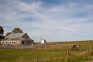
The Vander Wilt Farmstead Historic District, also known as the Heritage House Bed and Breakfast, is an agricultural historic district located north of Leighton, Iowa, United States. At the time of its nomination it included three contributing buildings, three contributing structures, one non-contributing building, and two non-contributing structures. The significance of the district is attributed to its association with progressive farming and the Country Life Movement, which sought to improve the living conditions of rural residents. The contributing buildings include the 1904 barn, the house (1920), the corn crib (1953), dairy barn (1955) and the feed lots. The two-story house was built by Douwe Sjaardema, a contractor from Pella, Iowa. The corn crib was built by the Iowa Concrete Crib & Silo Co. of Des Moines. The farm also includes a former landing strip for airplanes. It featured a 1,500-foot (460 m) grass runway where cows grazed on certain days. At one time it had a windsock and homemade landing lights. A hangar, no longer in existence, had been built in 1955. An automobile garage and two silos are the non-contributing resources. The district was listed on the National Register of Historic Places in 2004. The 1904 barn has subsequently been torn down.

Waterloo Ridge Lutheran Church is located northwest of the unincorporated community of Dorchester, Iowa, United States. It and the churchyard form a nationally recognized historic district that was listed on the National Register of Historic Places in 2015. At the time of its nomination, it consisted of three resources, which included one contributing building, one contributing site, and one contributing structure.

The Sentinel Block is a historic building located in Iowa Falls, Iowa, United States. Previous commercial blocks in Iowa Falls tended to follow the more ornate Italianate style. This building, completed in 1905, marks a departure from those older structures. Rectilinear brick panels above the windows replaced the decorative hoodmolds, and the brick patterned cornice with a plain stone cap replaced the heavy metal cornice. The building also features an oriel window with a crenelated parapet. The building housed the Iowa Falls Sentinel for over 20 years. It began as the Eldora Sentinel in 1857, relocated to Iowa Falls in 1865, and was bought out by its competitor, the Hardin County Citizen, in 1927.
The Eldora Downtown Historic District is a nationally recognized historic district located in Eldora, Iowa, United States. It was listed on the National Register of Historic Places in 2009. At the time of its nomination the district consisted of 84 resources, including 65 contributing buildings, one contributing site, three contributing objects and 15 non-contributing buildings. The district takes in the city's central business district, which also includes its governmental, educational, and religious activities. It is located in the original town plat from 1853. Development began around the public square and spread out from there. The present building stock is second generation at the earliest. The oldest extant buildings were built in the 1870s, although the greatest number of buildings were constructed in the 1890s. There were also peak years of construction in the 1910s, and the late 1930s and 1940s. The commercial buildings generally range from one to two stories, but the tallest structure is three stories in height. They are primarily composed of brick construction. Late Victorian and various revival styles from the late 19th and 20th centuries are dominant. The non-commercial buildings include four government buildings, four churches, three residences, a hospital, and a school.

The Civilian Conservation Corps-Prisoner of War Recreation Hall is a historic building located in Eldora, Iowa, United States. Known as Camp Flying Goose, the Civilian Conservation Corps' (CCC) Company 1755 made Eldora their home base in 1933. They constructed this building that year for their use as a barracks while they worked on projects in the area, which included building Upper Pine Lake in Pine Lake State Park. CCC Company 1752, the Erosioners, replaced them two years later, and they built many of the facilities in the park. With the start of World War II, the CCC left the camp. The National Youth Association used the camp from 1940 to 1942.

The Brown Street Historic District is a nationally recognized historic district located in Iowa City, Iowa, United States. It was listed on the National Register of Historic Places in 1994, and its boundaries were increased in 2004. At the time of the boundary increase it consisted of 246 resources, which included 201 contributing buildings, one contributing structure, and 44 non-contributing buildings. Brown and East Ronalds Streets are both part of the city's original plat when it was laid out as the capitol of the Iowa Territory. They are located on the north edge of the plat. Its significance is derived from the settlement patterns here, the development of a major transportation corridor, the neighborhood's affiliation with the University of Iowa and its growth around the turn of the 20th century, and the architectural styles and forms that are found here from the 1850s to the 1920s. Many of the city's Bohemian-immigrant population lived here. Businessmen and blue-collar workers lived side by side to each other, as did professors from the University of Iowa. The old Military Road was routed on Brown Street, and after it was paved with bricks in 1907, it became the preferred route for funeral processions to Oakland Cemetery.

The Johnson County Poor Farm and Asylum Historic District is a nationally recognized historic district located in Iowa City, Iowa, United States. It was listed on the National Register of Historic Places in 2014. At the time of its nomination it consisted of 11 resources, which included three contributing buildings, two contributing sites, four contributing structures and two non-contributing buildings. It also includes the First Johnson County Asylum, which was individually listed on the National Register. The remaining buildings and structures are agricultural in nature, and were built from the late 19th century to the early 20th century.
The Josias L. and Elizabeth A. Minor Farmstead District is an agricultural historic district located northwest of Ely, Iowa, United States. It was listed on the National Register of Historic Places in 2000. At the time of its nomination it consisted of five resources, which included four contributing buildings and one non-contributing structure. The historic buildings include a 1+1⁄2-story, T-plan, half-timbered house (1856); gabled barn #1 ; gabled barn #2 ; and the summer kitchen (1850s). The corncrib is the historic structure. Family lore says that Josias Minor settled here in 1846, but an 1878 biography of him gives September 1855 as the settlement date, which is used here for dating the buildings.

The Podhajsky-Jansa Farmstead District is an agricultural historic district located southwest of Ely, Iowa, United States. It was listed on the National Register of Historic Places in 2000. At the time of its nomination it consisted of 12 resources, which included five contributing buildings, four contributing structures, and three non-contributing structures. The historic buildings include two small side gabled houses ; a two-story, frame, American Foursquare house ; a gabled barn that was moved here from another farm ; and a feeder barn. One of two corncribs (1933), a hog house, and a chicken house are the historic structures. Another corncrib and a couple of metal sheds from the mid to late 20th century are the non-contributing structures.
The Hugh and Matilda Boyle House and Cemetery Historic District, also known as Boyleston Cemetery, is a nationally recognized historic district located west of Lowell, Iowa, United States. It was listed on the National Register of Historic Places in 2015. At the time of its nomination it consisted of three resources, which included one contributing building, one contributing site, and one non-contributing building.
The Washington and Elizabeth Miller Tract-Center-Soll Community Historic District is a nationally recognized historic district located in Des Moines, Iowa, United States. At the time of its nomination it consisted of 471 resources, which included 297 contributing buildings and 174 non-contributing buildings. It was listed on the National Register of Historic Places in 2017.


