Herron–Morton Place Historic District

Last updated

Herron–Morton Place Historic District
Talbott Street in Herron-Morton Place.jpg
Talbott Street in the southwestern part of the district
Location map Indianapolis.png
Red pog.svg
USA Indiana location map.svg
Red pog.svg
Usa edcp location map.svg
Red pog.svg
LocationRoughly bounded by Central Ave., 16th, Pennsylvania, and 22nd Sts., Indianapolis, Indiana
Coordinates 39°47′34″N86°9′9″W / 39.79278°N 86.15250°W / 39.79278; -86.15250 Coordinates: 39°47′34″N86°9′9″W / 39.79278°N 86.15250°W / 39.79278; -86.15250
Area147 acres (59 ha)
Built1822
ArchitectMultiple
Architectural style Classical Revival, Queen Anne, Tudor Revival
NRHP reference No. 83000131 [1]
Added to NRHPJune 16, 1983

Herron–Morton Place is a historic district in Indianapolis, Indiana, United States. The boundaries of the neighborhood are East 16th Street on the south, East 22nd Street on the north, North Pennsylvania Street on the west, and Central Avenue on the east. [2]

Contents

Herron–Morton Place Historic District is known for its collection of late 19th- and early 20th-century residential architecture. Many north–south streets in Herron—Morton (including Delaware, Alabama, and New Jersey streets) originally featured large esplanades down the center, adding to the spacious feeling of the lots and large homes. [3] Only New Jersey Street retains the original esplanades, providing an example of what the northern half of the neighborhood looked like. [4]

The neighborhood is notable as one of the city's earliest centers for LGBTQ culture, previously home to several gay bars and nightclubs, including the Club Betty K, 21 Club, Johnnie's Place, Harlow's, and Talbott Street. [5]

History

19th century

The area that makes up Herron-Morton Place was originally part of a 160-acre (65 ha) land patent granted to Thomas O’Neal in November 1822. In 1835, O'Neal sold the land to Samuel Henderson, the first Indianapolis postmaster and later, first mayor (1847-1849). The land was largely undeveloped, except for a 36-acre (15 ha) wooded tract, bounded roughly by what are now 19th, Talbott, and 22nd streets and Central Avenue. In the middle of the 19th century, it had become a popular picnic spot known as Henderson's Grove. In 1850, Henderson sold the land. Eighty acres (32 ha) west of Delaware Street were purchased by Elizabeth Tinker (the namesake of Tinker Street), and the area east of Delaware Street was purchased by William Otis. [6]

In 1859, the Indiana State Board of Agriculture purchased the land, which was still largely undeveloped, as a home for the Indiana State Fair. [6] [4]

At the start of the American Civil War, the area was used as an induction center for the Indiana Volunteer Infantry. Later in the war, it served as Camp Morton, a prisoner of war camp for Confederate soldiers that was named after Indiana's governor at the time, Oliver P. Morton. After the Civil War, it went back to being the state fairgrounds. A new exhibition building designed by Edwin May (later architect of the second, and current Indiana Statehouse) was constructed in 1873. The State Fair was held annually on the site until the current fairgrounds site on 38th Street was created in 1890. [7]

After the relocation of the fairgrounds, the site was purchased by three local businessmen, Willard Hubbard, Edward Claypool, and Elijah Martindale, who divided the property into 280 residential lots named Morton Place. It was designed as an upper-class residential neighborhood, boasting amenities such as esplanades, including those still present on North New Jersey Street.

Indiana Impressionist artists T.C. Steele and William Forsyth founded the Hoosier Group art school in Morton Place in 1888. In 1895, John Herron's bequest founded the John Herron Art Institute, and funded new construction of a new main building and an art museum in Morton Place. The Herron Museum later became the Indianapolis Museum of Art.

As Indianapolis expanded outward at the end of the 1800s, the area directly north of 16th Street was considered one of the city's most elegant residential neighborhoods and was home to many celebrated politicians, lawyers, physicians, business leaders, artists, and architects. [4]

20th century

The proliferation of the automobile and subsequent expansion of Indianapolis lured the well-to-do further away from the heart of the city and thus, from Herron-Morton. [7] The esplanades on Delaware and Alabama Streets were removed in the 1920s because they slowed traffic flow in and out of the city. When the Great Depression began, many of the large single-family homes were divided into multi-family dwellings, causing the neighborhood to further lose its appeal. Between 1950 and 1970, a considerable amount of housing stock was lost to fires and demolitions. [6] [7]

Revitalization efforts began in the 1970s, largely with graduates of the Herron School of Art choosing to stay in the neighborhood and buy and renovate homes. [6] In 1976, Herron–Morton Place Neighborhood Association was founded. The association spearheaded attempts to renovate homes, reduce crime, and rebuild the neighborhood spirit. [6] Herron-Morton was listed on the National Register of Historic Places in 1983, making structures in the district eligible for tax incentives, and became a historic preservation district in 1986. [8]

21st century

Public and private revitalization efforts have continued throughout the past several decades. Herron-Morton is again one of Indianapolis's most highly developed neighborhoods, and many homes that had been converted into multiple units in the 1930s, 1940s, and 1950s have now been converted back into single-family homes. [7] The historic district encompasses 574 contributing buildings in representative examples of Classical Revival, Queen Anne, and Tudor Revival style architecture. [9]

Herron School of Art and Design relocated to new buildings on the Indiana University-Purdue University Indianapolis campus in 2000 and 2005. The original Herron School of Art buildings now house Herron High School, a public charter school serving grades 9–12, [10] and Herron Preparatory Academy, serving grades K-8. They are contributing properties to the historic district.

The Willard and Josephine Hubbard House was individually listed on the National Register of Historic Places in 2016. [11]

Community

Since 1956, Herron–Morton Place has hosted the Talbot Street Art Fair, an annual juried art fair held on Talbott Street in June of each year. [12] The Herron–Morton Place Neighborhood Association was formed in 1976 to spearhead the renovation of homes, encourage new residential development, reduce crime, and rebuild community spirit.

The Herron–Morton Place Neighborhood Foundation raises funds to maintain a historic neighborhood park in the 1900 block of North Alabama Street and other beautification efforts throughout the neighborhood. The foundation plans several events each year that raise money for the neighborhood park, the most notable of which are the annual Oktoberfest in late September, the bi-annual home tour, and the year Rock 'N' Romp for families.

Related Research Articles

<span class="mw-page-title-main">Herron School of Art and Design</span> Art school in Indianapolis, Indiana, U.S.

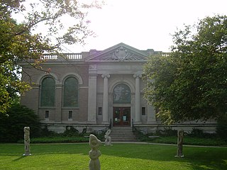
Herron School of Art and Design, officially IU Herron School of Art and Design, is a public art school at Indiana University–Purdue University Indianapolis (IUPUI) in Indianapolis, Indiana. It is a professional art school and has been accredited by the National Association of Schools of Art and Design since 1952.

<span class="mw-page-title-main">Haughville, Indianapolis</span> United States historic place

Haughville is a neighborhood west of downtown Indianapolis. Its borders are roughly White River Parkway to the east, Tibbs Avenue to the west, 16th Street to the north, and Michigan Street to the south. It was first settled in the 1830s and grew after a bridge over White River was built connecting to Indianapolis, which annexed the town in 1897. The modern version of the bridge is also the connection between Haughville on the west side of the river and the Sidney & Lois Eskenazi Hospital and Indiana University - Purdue University Indianapolis on the east. The population in the late 1890s included Slovenian, German, and Irish immigrants, among other European immigrants. In the 21st century, the neighborhood suffers from a high crime rate and low property values.

<span class="mw-page-title-main">Irvington Historic District (Indianapolis)</span> Historic district in Indiana, United States

The neighborhood of Irvington, named after Washington Irving, includes Irvington Historic District, a historic district in Indianapolis, Indiana. The historic district is a 545-acre (221 ha) area that was listed on the National Register of Historic Places in 1987. That year, the district included 2,373 contributing buildings, 5 other contributing structures, and 2 contributing sites.

<span class="mw-page-title-main">Fletcher Place</span> United States historic place

Fletcher Place is a historic district and neighborhood in the city of Indianapolis, Indiana named after Calvin Fletcher, a prominent local banker, farmer and state senator.

<span class="mw-page-title-main">Downtown Indianapolis</span> Central business district of Indianapolis, Indiana, U.S.

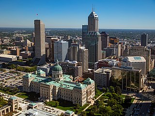
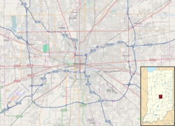
Downtown Indianapolis is a neighborhood area and the central business district of Indianapolis, Indiana, United States. Downtown is bordered by Interstate 65, Interstate 70, and the White River, and is situated near the geographic center of Marion County. Downtown has grown from the original 1821 town plat—often referred to as the Mile Square—to encompass a broader geographic area of central Indianapolis, containing several smaller historic neighborhoods.

<span class="mw-page-title-main">Woodruff Place, Indianapolis</span> United States historic place

Woodruff Place is a neighborhood in Indianapolis located about a mile east of Downtown Indianapolis. It was established in the 1870s by developer James O. Woodruff as an early suburb of Indianapolis. Woodruff Place's boundaries are: 10th Street on the north, Woodruff Place West Drive on the west, Michigan Street on the south, and Woodruff Place East Drive on the east. This community was an independent municipality and maintained autonomy, even as the City of Indianapolis grew and expanded around the neighborhood, enclosing the community well within the city limits. Woodruff Place was incorporated in 1876 and remained an independent town until 1962 when it became one of the final municipalities to be annexed by the City of Indianapolis prior to the merger of city and county governments in 1969.

<span class="mw-page-title-main">Golden Hill Historic District (Indianapolis, Indiana)</span> Historic district in Indiana, United States

Golden Hill is an affluent and historic neighborhood overlooking the White River on the west side of Indianapolis's Center Township, in Marion County, Indiana. The district is bounded on the east by Clifton Street, which is west of Martin Luther King Jr. Boulevard ; on the west by the White River and the Central Canal; on the south by Thirty-sixth Street; and on the north by Woodstock Country Club, immediately south of Thirty-eighth Street. Golden Hill is noted for its collection of homes designed by several of the city's prominent architects. The estate homes reflect several styles of period revival architecture. The district is known as for its community planning and remains an exclusive enclave for the city's prominent families. Golden Hill was added to the National Register of Historic Places in 1991.

<span class="mw-page-title-main">Fountain Square, Indianapolis</span> Neighborhood and cultural district in Indianapolis, Indiana, U.S.

Fountain Square is one of seven designated cultural districts in Indianapolis, Indiana. Located just outside the city's downtown district, Fountain Square is home to three designated national historic districts, the Laurel and Prospect, the State and Prospect, and the Virginia Avenue districts, all of which were listed on the National Register of Historic Places in 1983. The neighborhood derives its name from the successive fountains that have been prominently featured at the intersection of Virginia Avenue, East Prospect Street, and Shelby Street.

The Bates–Hendricks neighborhood is situated just south and east of the downtown commercial district of Indianapolis, Indiana. The Fountain Square business district is just to the east.

<span class="mw-page-title-main">Camp Morton</span> Civil War training area in Indianapolis, IN, US

Camp Morton was a military training ground and a Union prisoner-of-war camp in Indianapolis, Indiana, during the American Civil War. It was named for Indiana governor Oliver Morton. Prior to the war, the site served as the fairgrounds for the Indiana State Fair. During the war, Camp Morton was initially used as a military training ground. The first Union troops arrived at the camp in April 1861. After the fall of Fort Donelson and the Battle of Shiloh, the site was converted into a prisoner-of-war camp. The first Confederate prisoners arrived at Camp Morton on February 22, 1862; its last prisoners were paroled on June 12, 1865. At the conclusion of the war, the property resumed its role as the fairgrounds for the Indiana State Fair. In 1891 the property was sold and developed into a residential neighborhood known as Morton Place, a part of the Herron-Morton Place Historic District.

<span class="mw-page-title-main">Lockerbie Square Historic District</span> Historic district in Indiana, United States

Lockerbie Square Historic District is a national historic district on the National Register of Historic Places within Indianapolis, Indiana, listed on February 23, 1973, with a boundary increase on July 28, 1987. It is noted for its Federal, Italianate, and Queen Anne style architecture. The original platting of Lockerbie Square, done by Jannett Smith Lockerbie McOuat and named for her father, Scottish immigrant George Murray Lockerbie, was between 1847 and 1850. The 1960s saw an immense effort to save the buildings within the district, becoming the first historic district in Indianapolis. Many of the buildings date from 1855 to 1930. James Whitcomb Riley, famed Hoosier poet, lived in the district for over two decades. He was known to give candy to local children on his regular walks.

<span class="mw-page-title-main">Old Northside Historic District</span> Historic district in Indiana, United States

Old Northside is a residential neighborhood near downtown in Indianapolis, Indiana. It is bordered by 16th Street on the north, Pennsylvania Street on the west, Interstate I-65 on the south, and Bellefontaine Street on the east. The Monon Trail runs along the eastern edge of The Frank and Judy O'Bannon Old Northside Soccer Park.

<span class="mw-page-title-main">Meridian Street (Indianapolis)</span> Primary north-south street in Indianapolis, Indiana, U.S.

Meridian Street is the primary north–south street in Indianapolis, Indiana.

<span class="mw-page-title-main">Oliver Johnson's Woods Historic District</span> Historic district in Indiana, United States

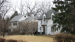
Oliver Johnson's Woods is a historic district and neighborhood on the northern side of Indianapolis, Indiana, United States. Located in southern Washington Township, the district occupies the site of what was once the family farm of Oliver Johnson. Born on the present site of the Indiana State Fairgrounds, Johnson grew up in a pioneer family that lived on the edge of the state capital city. Upon attaining adulthood, he bought property a short distance to the west, to which he moved in 1846. Here, he built a larger farmhouse in 1862, and he tilled the soil for most of the rest of his life. As Indianapolis grew northward, it reached the Johnson farm in the early twentieth century; the aged farmer and his sons saw the city's growth as an opportunity for financial gain, and in 1905 they announced the platting of 0.25 square miles (0.65 km2) of their property into individual lots. They chose an advantageous time to sell their property; as the new residents began to build their homes, an interurban railway was built along College Avenue on the district's western side that connected downtown with Broad Ripple. Many prosperous businessmen were attracted by the development's large lots and wooded streets; the city annexed Oliver Johnson's Woods in 1912, and by the outbreak of World War II, the streets were filled with large houses built in a wide variety of architectural styles. These early residents came from many different ethnicities: European immigrants were becoming more prosperous and leaving their ethnic enclaves, and new neighborhoods such as Oliver Johnson's Woods appealed to them. Among the neighborhood's leading residents was a colony of Jews of German descent.

<span class="mw-page-title-main">Cottage Home Historic District</span> Historic district in Indiana, United States

The Cottage Home Historic District is a historic district and neighborhood located on the near east side of Indianapolis, Indiana. A small portion of Cottage Home is listed on the National Register of Historic Places while a larger area is listed on the state and local levels. Known for its preponderance of "cottage-style" homes built with strong Victorian influences, Cottage Home has historically been a working class neighborhood. Numerous industrial buildings are also scattered throughout the district, providing a base of economic activity. Today, however, many of these buildings are vacant, providing a special challenge to preservation and urban renewal efforts.

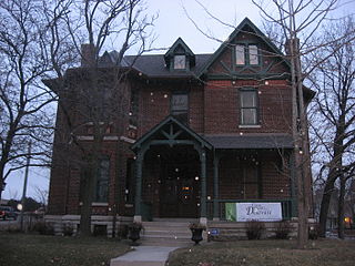
Tee Pee Restaurant was a drive-in restaurant in Indianapolis, Indiana, that began business in 1932. In 1939, the original building on Fall Creek Boulevard was replaced with one having a central stuccoed teepee-shaped section with identical flanking wings. A cantilevered canopy extended around the building. Additions were made to the wings in 1952.

<span class="mw-page-title-main">Willard and Josephine Hubbard House</span> Historic house in Indiana, United States

Willard and Josephine Hubbard House is a historic home located at Indianapolis, Indiana. It was built in 1903, and is a 2+12-story, five-bay, center-hall plan, Italian Renaissance Revival style limestone dwelling with an addition. It features a front wooden portico supported by Ionic order columns and a semi-circular front section. Also on the property is a contributing carriage house / garage.

<span class="mw-page-title-main">St. Joseph Neighborhood Historic District</span> Historic district in Indiana, United States

St. Joseph Neighborhood Historic District is a national historic district located at Indianapolis, Indiana. The district encompasses 57 contributing buildings in a predominantly residential section of Indianapolis. It was developed between about 1855 and 1930, and include representative examples of Italianate and Queen Anne style architecture. Located in the district are the separately listed Bals-Wocher House, William Buschmann Block, Delaware Court, Pearson Terrace, and The Spink. Other notable buildings include the Christian Place complex, Fishback-Vonnegut-New House, Henry Hilker House, Apollo-Aurora Rowhouses, Israel Traub Store, and Lorenzo Moody House.

<span class="mw-page-title-main">Beth-El Zedeck Temple</span> United States historic place

Beth-El Zedeck Temple, originally known as Beth-El Temple, is a historic synagogue located in the Mapleton-Fall Creek neighborhood in Indianapolis, Indiana, United States. The building was completed in 1924, and was originally home to Congregation Beth-El before merging with the Ohev Zedeck congregation in 1928. It is the oldest remaining synagogue structure in Indianapolis.

Harrison Center is a community-based arts nonprofit based in the Old Northside Historic District of Indianapolis, Indiana, United States. The center hosts 36 artists in 24/7 studios, eight galleries, and serves 93,000 annually.

References

  1. "National Register Information System". National Register of Historic Places . National Park Service. March 13, 2009.
  2. "Our Neighborhood". Herron-Morton Place. June 5, 2013. Retrieved May 12, 2021.
  3. "Herron-Morton Place Historic District--Indianapolis: A Discover Our Shared Heritage Travel Itinerary". www.nps.gov. Retrieved May 12, 2021.
  4. 1 2 3 "Our History". Herron-Morton Place. June 5, 2013. Retrieved May 12, 2021.
  5. Donnelly, Cathleen F.; Van Allen, Elizabeth J. (2021) [1994]. "Herron–Morton Place" (website). Digital Encyclopedia of Indianapolis. Indianapolis Public Library. Retrieved September 15, 2022.
  6. 1 2 3 4 5 "Tour - Herron-Morton Place Neighborhood - PocketSights". pocketsights.com. Retrieved May 12, 2021.
  7. 1 2 3 4 "HUNI:: Herron Morton". www.huniindy.org. Retrieved May 12, 2021.{{cite web}}: CS1 maint: url-status (link)
  8. Indianapolis Historic Preservation Commission (October 1, 1986). "Historic Area Preservation Plan - Herron-Morton Place" (PDF). Retrieved May 12, 2021.{{cite web}}: CS1 maint: url-status (link)
  9. "Indiana State Historic Architectural and Archaeological Research Database (SHAARD)" (Searchable database). Department of Natural Resources, Division of Historic Preservation and Archaeology. Retrieved August 1, 2016.Note: This includes Alan Goebes (February 1983). "National Register of Historic Places Inventory Nomination Form: Herron–Morton Place Historic District" (PDF). Retrieved August 1, 2016. and Accompanying photographs
  10. "Awards & Accolades". Herron High School. Retrieved May 12, 2021.
  11. "National Register of Historic Places Listings". Weekly List of Actions Taken on Properties: 6/06/16 through 6/10/16. National Park Service. June 17, 2016.
  12. Blair, Lyndsey D. (February 2021). "Talbot Street Art Fair" (website). Digital Encyclopedia of Indianapolis. Indianapolis Public Library. Retrieved September 15, 2022.