
Sugar House is a neighborhood in Salt Lake City, Utah. The name is officially two words, although it is often colloquially written as "Sugarhouse." As a primary commercial and residential hub of the region, it is often referred to as Salt Lake's "Second Downtown." Once a primarily residential area with a suburban-style retail hub, the neighborhood has transformed in recent years as mid-rise offices, residential blocks, and hotels have been constructed in the vicinity of Sugar House Park.

Salt Lake City, Utah has many historic and notable sites within its immediate borders. Although the entire Salt Lake City metropolitan area is often referred to as "Salt Lake City", this article is concerned only with the buildings and sites within the official city limits of Salt Lake City.

Transportation in Salt Lake City consists of a wide network of roads, an extensive bus system, a light rail system, and a commuter rail line. Although Salt Lake City, Utah, is a traditionally car-oriented city, the rapidly growing public transit system has a high number of riders for a city of its size, and public transit is widely supported by its residents and businesses.
The Greater Richmond, Virginia area has many neighborhoods and districts.

Reynoldstown is a historic district and intown neighborhood on the near east side of Atlanta, Georgia, located two miles from downtown. The neighborhood is gentrifying and attracting new families, empty-nesters, Atlantans opposed to long commutes; as well as diverse culture of first-time homebuyers, single professionals, artist and students due to its close proximity to other nearby intown neighborhoods, high walkability index, urban amenities and nearby bohemian hotspots on Carroll Street in the adjoined-at-the-hip also historic Cabbagetown neighborhood and in other surrounding communities.

The Blue Line is a light rail line on the TRAX system in the Salt Lake Valley of Utah, in the United States, operated by the Utah Transit Authority (UTA). It is the first line of the TRAX system completed. The line opened on December 4, 1999, one year ahead of schedule after two years of construction. In addition to Salt Lake City, it also serves the communities of South Salt Lake, Murray, Midvale, Sandy and Draper. The line was known as the North/South Line or the Sandy/Salt Lake Line until color names were adopted for each TRAX line in August 2011. An extension of the line to Draper began service on August 18, 2013.

State Route 186 (SR-186) is a state highway entirely within Salt Lake City, capital of the U.S. state of Utah. It forms a quarter-beltway connecting US-89 and I-15 leading north from Salt Lake City to I-80 leading east; as such, it effectively forms the missing (non-freeway) quarter of the I-215 belt route around the city, though it does not directly connect to I-215 at the north end. Despite this beltway role, the route passes through downtown Salt Lake City because downtown is built right up to the northern mountains surrounding City Creek Canyon. The portion of the route connecting downtown to I-80 is a high-capacity street heavily used by commuters, especially those travelling to the University of Utah or between downtown and eastern neighborhoods, but the portion on Capitol Hill north of downtown is much narrower and has sharp turns around the Capitol grounds. The roadway runs 9.34 miles (15.03 km) along Victory Road, Columbus Street, 300 North, State Street, 400 South, 500 South, and Foothill Drive.
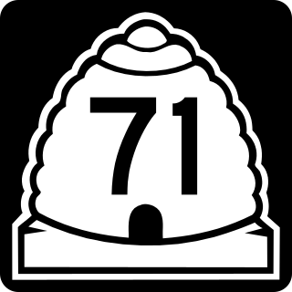
State Route 71 (SR-71) is a state highway completely within the Salt Lake City metropolitan area in the northern portion of the US state of Utah. It runs from SR-154 in the southwest side of the city to SR-186 in Downtown Salt Lake City. The route spans 22.47 miles (36.16 km) as it runs along portions of 12600 South, 12300 South, 900 East, and 700 East streets.
Columbus, the state capital and Ohio's largest city, has numerous neighborhoods within its city limits. Neighborhood names and boundaries are not officially defined. They may vary or change from time to time due to demographic and economic variables.

Ponce de Leon Avenue, often simply called Ponce, provides a link between Atlanta, Decatur, Clarkston, and Stone Mountain, Georgia. It was named for Ponce de Leon Springs, in turn from explorer Juan Ponce de León, but is not pronounced as in Spanish. Several grand and historic buildings are located on the avenue.

State Route 181 (SR-181) was a state highway in the U.S. state of Utah connecting SR-152 in Murray and Holladay north to SR-186 in Salt Lake City at its peak, the former being suburbs of the latter. The route was 6.9 miles (11.10 km) for thirty-eight years before being truncated in 2007 and decommissioned entirely later in the same year.

The S Line, or S-Line, is a public transit streetcar line in northeastern Salt Lake County, Utah, in the United States, that connects the business district of the Sugar House neighborhood of Salt Lake City with the neighboring city of South Salt Lake, as well as the Utah Transit Authority's (UTA) TRAX light rail system. It is a joint project between UTA, Salt Lake City, and South Salt Lake. It opened for service on December 8, 2013. It is operated by UTA and is UTA's first streetcar line.

The Forest Dale Historic District is located in the southeastern part of Salt Lake City, Utah and is roughly bounded by 700 East, Interstate 80, Commonwealth Avenue, and 900 East. It includes the "cohesive core" of the Forest Dale Subdivision platted in 1890, as well as the larger Town of Forest Dale, which was incorporated on January 6, 1902, disincorporated in the fall of 1912, and reabsorbed into the city of Salt Lake City. Both the subdivision and town were created by George Mousley Cannon, a member of the Cannon family, a prominent Intermountain West political family. The land for Forest Dale was originally Forest Farm, which Cannon had bought in 1889 from the estate of Brigham Young. Despite being bordered on 2 sides by major traffic corridors and on a third by a major arterial highway, the district "maintains its historic "inner-ring" suburban quality due to its tree-lined streets, uniform setbacks, and the similarity of scale in the housing stock." Forest Dale Golf Course is just southeast across I-80, and Fairmont Park is just to the east, separating Forest Dale from downtown Sugar House. The S Line includes two stops near Forest Dale and Parley's Trail runs along the streetcar line. The streetcar and trail opened in late 2013 and early 2014, respectively.

East Bench in Salt Lake City, Utah is a relatively affluent and primarily residential neighborhood or collection of neighborhoods in Salt Lake City that lies at the base of the Wasatch Range and extends west to approximately 1300 East.

Main Street is the most important commercial street in Salt Lake City, Utah, United States though it also extends south into the cities of South Salt Lake, Millcreek, and Murray. Its commercial importance is almost totally derived from the few blocks of the street which are immediately south of Temple Square that have attracted banks, major retailers, and heavy foot traffic throughout Salt Lake City's history; the long southern extension of Main Street south of about 500 and 600 South, in contrast, is always in the shadow of State Street, which is more designed for the long-distance automobile traffic that is common away from downtown.
State Street is a wide 17.3-mile-long (27.8 km) street in Salt Lake County, Utah leading almost straight south from the steps of the Utah State Capitol Building, through Salt Lake City, South Salt Lake, Millcreek, Murray, eastern Midvale, Sandy, and northwestern Draper. Because it follows the most direct route from downtown Salt Lake City to the Point of the Mountain pass to Utah County, it was the undisputed main road south from Salt Lake City until Interstate 15 (I-15) was built to the west. It retains the U.S. Highway 89 designation for all but the northernmost seven blocks despite I-15's proximity. Due to its history as a route for long-distance travel, travel within the Wasatch Front region, and travel between the cities along the east side of the Jordan River, it has attracted a wide variety of retail and service businesses along its entire length, creating a nearly continuous commercial axis for the Salt Lake Valley.
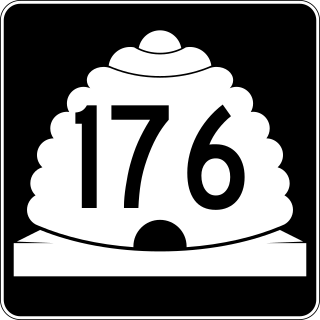
Utah State Route 176 was a state highway in entirely within the cities of Salt Lake City and South Salt Lake in Salt Lake County, Utah, United States. It mainly functioned as an alternate route for US-89, US-91, and I-15 traffic that provided access to industrial areas of the two cities and avoided urban cross-traffic in Downtown Salt Lake City. The original route followed 900 South west from State Street to 300 West and then traveled north on 300 West to meet US-89 and US-91 again at South Temple. The route was subsequently changed to follow 300 West only: it followed 300 West all the way from 3300 South (SR-171) to North Temple.

Yalecrest is an affluent residential neighborhood located on the East Bench of Salt Lake City and is known for the architectural variety and rare collection of turn-of-the-century homes – all within a six block radius bordered by the South Side of Sunnyside Avenue, North Side of 1300 South, East Side of 1300 East and West Side of 1900 East. Yalecrest is commonly referred to as the "Harvard-Yale area" and several streets are named after Ivy League universities. It is a remarkably visually cohesive area with uniform setbacks, historic houses of the same era with comparable massing and landscaping, as well as streets lined with mature shade trees, and a surprising level of contributing structures that retain their historic integrity. Yalecrest contains 1,487 homes that were built in the early 20th century starting as early as 1912 with the vast majority (74%) built during the period of 1920–1940. The remaining homes in the easternmost part of the neighborhood were built during the post war boom. Yalecrest has the largest concentration of period revival English Cottages, English Tudors, French Norman and Spanish Colonial homes anywhere in Utah. These houses exhibit a variety of period revival styles with the largest portion being English Tudor and English Cottage. According to the Salt Lake City Planning Department, the architectural variety and concentration of period cottages found in Yalecrest are "unrivalled in the state." Examples from Yalecrest are used to illustrate period revival cottages styles in the only statewide architectural style manual. There are 22 subdivisions which were platted and built by the prominent architects and developers of the day responsible for early 20th Century east side Salt Lake City development.. Yalecrest has been on the National Register of Historic Places since November 8, 2007. One home in the neighborhood, the George Albert Smith home at 1302 Yale Avenue, is listed on the National Register since 1993.

