
Botafogo is a beachfront neighborhood (bairro) in Rio de Janeiro, Brazil. It is a mostly upper middle class and small commerce community, and is located between the hills of Mundo Novo, Dona Marta and São João. The word Botafogo also refers to a Latin American ballroom dance move, named so because the area of Botafogo is where it originated.
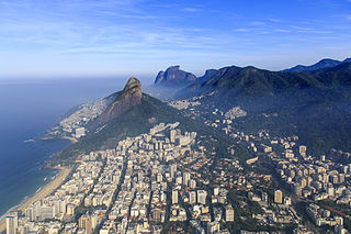
Leblon is a neighborhood of Rio de Janeiro, Brazil. It is also the name of the local beach. The neighborhood is located in the South Zone of the city, between Lagoa Rodrigo de Freitas, Morro Dois Irmãos and the Jardim de Alá channel, bordering the Gávea, Ipanema, Lagoa, and Vidigal neighborhoods. It is regarded as having the most expensive price per residential square meter in Latin America.
Jacarepaguá, with a land area of 29.27 square miles (75.8 km2), is a neighborhood situated in the West Zone of Rio de Janeiro, Brazil. In 2010, it had a population of 157,326. The name comes from the indigenous name of the location, "shallow pond of caymans", yakaré + upá (pond) + guá (shallow), by the time of the Portuguese invasion.
Maracanã is a middle-class neighborhood in the Northern Zone of Rio de Janeiro city. The Maracanã Stadium is located in this neighborhood, as well as the Ginásio do Maracanãzinho. Maracanã is bordered by these neighborhoods: Praça da Bandeira, Tijuca and Vila Isabel.
José Joachim de Sá Freire Alvim (1909–1981) was a Brazilian mayor of the Distrito Federal of Rio de Janeiro from 1958 to 1960.

Complexo do Alemão is a group of favelas in the North Zone of Rio de Janeiro, Brazil.

Centro ("Center") is a neighborhood in Zona Central of Rio de Janeiro, Brazil. It represents the financial heart of the city, and the crux of the Central Region.

Abolição (Abolition) is a middle-class neighborhood of the North Zone of the city of Rio de Janeiro, Brazil.

Catete is a neighborhood in South Zone of Rio de Janeiro, Brazil. It has strong commerce, with the majority of population being middle class.
Santo Cristo is a neighborhood in Rio de Janeiro, Brazil. The neighbourhood is named after the Catholic church Santo Cristo dos Milagres situated in the port area.

Praça da Bandeira is a neighborhood in the North Zone of Rio de Janeiro, Brazil.

Freguesia is a neighborhood in the North Zone of Rio de Janeiro, Brazil.

Galeão is a neighborhood in the North Zone of Rio de Janeiro, Brazil. It is located on Governador Island besides the Rio de Janeiro–Galeão International Airport.
Jardim Carioca is a neighborhood in the North Zone of Rio de Janeiro, Brazil.
Parque Anchieta is a neighborhood in the North Zone of Rio de Janeiro, Brazil.
Tomás Coelho is a neighborhood in the North Zone of Rio de Janeiro, Brazil.
Jardim Sulacap is a neighborhood in the West Zone of Rio de Janeiro, Brazil.
The Lagoa–Barra Highway, officially named Engenheiro Fernando Mac Dowell Highway, is a highway linking Gávea and Barra da Tijuca in Rio de Janeiro, Brazil. The highway was opened in 1971.

Teleférico da Providência is a gondola lift service operating in the Central region of Rio de Janeiro, Brazil. The cable car runs between Central do Brasil and Gamboa, Rio de Janeiro, servicing the unofficial neighborhood of Providência.


