Seven Sisters is a village and community in the Dulais Valley, Wales, UK. It lies 10 miles (16 km) north-east of Neath. Seven Sisters falls within the Seven Sisters ward of Neath Port Talbot county borough.

Maltby is a former mining town and civil parish in the Metropolitan Borough of Rotherham, South Yorkshire, England. It was historically in the West Riding of Yorkshire. It is located 6 miles (10 km) east of Rotherham and 10 miles (16 km) north-east of Sheffield. It forms a continuous urban area with Hellaby, separated from the rest of Rotherham by the M18 motorway. It had a population of 16,688 at the 2011 Census.

The National Coal Board (NCB) was the statutory corporation created to run the nationalised coal mining industry in the United Kingdom. Set up under the Coal Industry Nationalisation Act 1946, it took over the United Kingdom's collieries on "vesting day", 1 January 1947. In 1987, the NCB was renamed the British Coal Corporation, and its assets were subsequently privatised.
Murton is a village in County Durham, England. Lying eight miles (13 km) east of the city of Durham and six miles (9.7 km) south of Sunderland, it has a population of 4,534, increasing to 7,676 at the 2011 Census.
Burnbank is an area in the town of Hamilton, South Lanarkshire, Scotland. It was formerly a separate mining village before being absorbed into the town.

Cronton is a village and civil parish within the Metropolitan Borough of Knowsley, Merseyside, in England. The village is surrounded by green belt land. Over the county border in Cheshire, Widnes town centre is 2.3 miles (3.7 km) to the south-southeast.

Creswell is a former mining village located in the Bolsover district of Derbyshire, England. At the 2011 Census population details were included in the civil parish of Elmton-with-Creswell. Today it is best known for Creswell Crags and its model village. In September 1950 Creswell Colliery was the scene of one of the worst post-nationalisation mining disasters. Elmton Common is an area of allotments for the township of Creswell.

Kibblesworth is a village 2 miles (3.2 km) west of Birtley, Tyne and Wear, England. Kibblesworth was a mainly rural community until the development of the pit and brickworks and the resulting increase in population. Following the closure of the pit in 1974, few of the residents now work in the village. Historically in County Durham, it was transferred into the newly created county of Tyne and Wear in 1974.

Cwmparc is a village and a district of the community of Treorchy, in the Rhondda Valley, Wales.
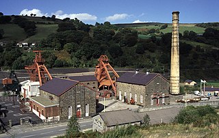
Rhondda Heritage Park, Trehafod, Rhondda, South Wales, is a tourist attraction which offers an insight into the life of the coal mining community that existed in the area until the 1980s.

Fochriw is a village in Caerphilly County Borough, Wales. It was well known for its neighbouring collieries, which employed nearly the entire local population in the early 20th century. It lies within the historic county boundaries of Glamorgan. The village appears as the backdrop on the BBC Wales sitcom High Hopes credits. The village's population was 1,250 in 2011.

Springside is a village in the parish of Dreghorn, in the council area of North Ayrshire, Scotland. It is three miles from Irvine, 1+1⁄2 miles west of Crosshouse, and four miles from Kilmarnock. In the 18th, 19th and mid-20th centuries, the locality was a highly industrialised coal mining district. The settlement is on the Garrier Burn, which forms the boundary with East Ayrshire. Springside had a population of around 1364 in 1991. The A71 now bypasses the village, 1⁄4 mile to the south.

Mining in Wales provided a significant source of income to the economy of Wales throughout the nineteenth century and early to mid twentieth century. It was key to the Industrial Revolution in Wales, and to the whole of Great Britain.

Caerau is a former mining village in the community of Maesteg, Bridgend County Borough, Wales, located approximately 2 miles north of the centre of Maesteg town in the Llynfi Valley. Caerau, surrounded by mountainous terrain and forestry, is one of the border points between Bridgend County Borough and Neath Port Talbot County Borough, bordered to the north by Croeserw and Cymmer, Neath Port Talbot. Caerau, borders Dyffryn and Spelter to the south in Nantyffyllon, Maesteg.

California is a former pit village in the Falkirk council area of Scotland. It lies between Shieldhill and Avonbridge on the uplands which form the southern edge of the council area.

The Eglinton Castle estate was situated at Irvine, on the outskirts of Kilwinning, North Ayrshire, Scotland in the former district of Cunninghame. Eglinton Castle, was once home to the Montgomeries, Earls of Eglinton and chiefs of the Clan Montgomery. Eglinton Country Park now occupies part of the site.
Marley Hill is a former colliery village about six miles to the south west of Gateshead, near the border between Tyne and Wear and County Durham. It has been part of the Metropolitan Borough of Gateshead since 1974. Prior to this it was part of Whickham Urban District. It lies within the Whickham South & Sunniside electoral ward of the Blaydon parliamentary constituency.

The Lancashire Coalfield in North West England was an important British coalfield. Its coal seams were formed from the vegetation of tropical swampy forests in the Carboniferous period over 300 million years ago.

Bentley Colliery was a coal mine in Bentley, near Doncaster in South Yorkshire, England, that operated between 1906 and 1993. In common with many other mines, it suffered disasters and accidents. The worst Bentley disaster was in 1931 when 45 miners were killed after a gas explosion. The site of the mine has been converted into a woodland.
Lassodie is an abandoned settlement located two miles south-west of Kelty, between Dunfermline and Cowdenbeath, in Fife.

