
Hobart is the capital and most populous city of the Australian island state of Tasmania. Home to almost half of all Tasmanians, it is the least-populated Australian state capital city, and second-smallest if territories are taken into account, before Darwin, Northern Territory. Hobart is located in Tasmania's south-east on the estuary of the River Derwent, making it the most southern of Australia's capital cities. Its skyline is dominated by the 1,271-metre (4,170 ft) kunanyi/Mount Wellington, and its harbour forms the second-deepest natural port in the world, with much of the city's waterfront consisting of reclaimed land. The metropolitan area is often referred to as Greater Hobart, to differentiate it from the City of Hobart, one of the five local government areas that cover the city. It has a mild maritime climate.

The River Derwent is a river located in Tasmania, Australia. It is also known by the palawa kani name timtumili minanya. The river rises in the state's Central Highlands at Lake St Clair, and descends more than 700 metres (2,300 ft) over a distance of more than 200 kilometres (120 mi), flowing through Hobart, the state's capital city, before emptying into Storm Bay and flowing into the Tasman Sea. The banks of the Derwent were once covered by forests and occupied by Aboriginal Tasmanians. European settlers farmed the area and during the 20th century many dams were built on its tributaries for the generation of hydro-electricity.

Mount Wellington ) is a mountain in the southeast of Tasmania, Australia. It is the summit of the Wellington Range and is within Wellington Park reserve. Hobart, Tasmania's capital city, is located at the foot of the mountain.

Maria Island or 'wukaluwikiwayna' in [palawa kani) is a mountainous island located in the Tasman Sea, off the east coast of Tasmania, Australia. The 115.5-square-kilometre (44.6 sq mi) island is contained within the Maria Island National Park, which includes a marine area of 18.78 square kilometres (7.25 sq mi) off the island's northwest coast. The island is about 20 kilometres (12 mi) in length from north to south and, at its widest, is about 13 kilometres (8.1 mi) west to east. At its closest point, Point Lesueur, the island lies approximately 4 kilometres (2.5 mi) off the east coast of Tasmania.

Taroona High School is a government co-educational comprehensive junior secondary school located in Taroona, a suburb of Hobart, Tasmania, Australia. Established in 1958, the school caters for approximately 1,100 students from Years 7 to 10. The school is administered by the Tasmanian Department of Education.

Taroona is a major residential suburb approximately 15 minutes drive from the centre of Hobart, Tasmania on the scenic route between Hobart and Kingston. Although on the edges of the City of Hobart, Taroona is actually part of the municipality of Kingborough. Taroona is bounded on the east by the Derwent River, and has several beaches along the shore, the main beaches with public access are Taroona Beach, Hinsby Beach and Dixons Beach. Past Hinsby Beach, the Alum Cliffs form a section of cliffed coast to the neighbouring suburb of Bonnet Hill.
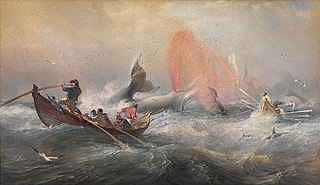
Whaling in Australian waters began in 1791 when five of the 11 ships in the Third Fleet landed their passengers and freight at Sydney Cove and then left Port Jackson to engage in whaling and seal hunting off the coast of Australia and New Zealand. The two main species hunted by such vessels in the early years were right and sperm whales. Humpback, bowhead and other whale species would later be taken.

The D'Entrecasteaux Channel is a body of water located between Bruny Island and the south-east of the mainland of Tasmania, Australia. The channel is the mouth for the estuaries of the Derwent and the Huon Rivers and empties into the Tasman Sea of the South Pacific Ocean. It was sighted by Abel Tasman in 1642 and surveyed in 1792 by Bruni d'Entrecasteaux.
Cornelian Bay is a small suburb in Hobart, Tasmania, Australia. It lies just north of the urban parkland, the Queens Domain. The bay itself is a safe anchorage for yacht owners.

Rose Bay is a suburb of the City of Clarence in greater Hobart, capital city of Tasmania, Australia. Rose Bay is a small suburb, making up only approximately 0.9 square kilometres with nearly one fourth of that area (23.2%) being parkland. At the 2016 Census the suburb recorded a population of 1,102 people.
Bonnet Hill is a residential locality in the local government area (LGA) of Kingborough in the Hobart LGA region of Tasmania. The locality is about 2 kilometres (1.2 mi) east of the town of Kingston. The 2016 census recorded a population of 505 for the state suburb of Bonnet Hill.

Kingston Beach is a residential locality in the local government area (LGA) of Kingborough in the Hobart LGA region of Tasmania. The locality is about 2 kilometres (1.2 mi) south-east of the town of Kingston. The 2016 census recorded a population of 1990 for the state suburb of Kingston Beach.

Bass Strait Ferries have been the ships that have been used for regular transport across Bass Strait between Tasmania and Victoria in mainland Australia, as well as the various attempts to link Tasmania with Sydney. Historically, some regular shipping services in the twentieth century linked Sydney, Melbourne and Hobart with the Bass Strait ports: Launceston's various port locations, Devonport and Burnie. The distinction between coastal shipping and Bass Strait ferry has been blurred at times.

Nutgrove Beach is a popular beach destination along the River Derwent in Sandy Bay, Hobart, Tasmania. The north facing beach has views of kunanyi / Mount Wellington, Lords Beach, Wrest Point Hotel Casino, the Tasman Bridge, and the City of Clarence on the eastern shore. Nutgrove Beach neighbours Long Beach and Red Chapel Beach, and is within close proximity to the Sandy Bay Sailing Club and Lower Sandy Bay shops. The beach is dog-friendly and has bathroom facilities.

Long Beach is a popular beach destination along the River Derwent in Sandy Bay, Hobart, Tasmania. The east facing beach has views of the City of Clarence on the eastern shore and Blinking Billy Point. Long Beach neighbours Nutgrove Beach and is within close proximity to the Long Beach Reserve Playground, Sandy Bay Sailing Club, Sandy Bay Regatta Association, Hobart Pétanque Club and Lower Sandy Bay shops. Long Beach has a sea pontoon for swimmers and bathroom facilities.
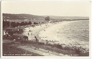
Bellerive Beach is a popular beach destination along the River Derwent in Bellerive, Hobart, Tasmania. The south facing beach neighbours the historic Kangaroo Battery coastal defences and has views of the Derwent estuary, Howrah, Tranmere and Sandy Bay on the western shore. Bellerive Beach has an adjoining parkland with play equipment, barbecues and bathroom facilities and is backed by the Bellerive Oval, a narrow tree-lined reserve and private properties.

Lords Beach is a suburban beach along the River Derwent in Sandy Bay, Hobart, Tasmania. The north-east facing beach has views of Wrest Point Hotel Casino, Nutgrove Beach and the City of Clarence on the eastern shore. Containing several raised jetties and covered piers, Lords Beach neighbours Red Chapel Beach to the west and Dunkley’s Point on the east.
Taroona Beach is a popular beach destination along the River Derwent in Taroona, Hobart, Tasmania. The south facing beach looks directly out to Storm Bay and the Tasman Sea, with views of the Derwent estuary, the City of Clarence on the eastern shore, Opossum Bay, South Arm, the Alum Cliffs and northern tip of Bruny Island. Taroona Beach is situated between Hinsby Beach and Crayfish Point, home of the Fisheries and Aquaculture Centre for the Institute for Marine and Antarctic Studies. Taroona Beach contains a boat ramp and is backed by Taroona Park which contains bathroom facilities, a skate park, scout hall, the Taroona Tennis Club, and the Taroona Bowls and Community Club.
The Alum Cliffs are a section of cliffed coast facing the Derwent Estuary and Storm Bay along the suburbs of Taroona, Bonnet Hill, and Kingston Beach, Tasmania, Australia. Composed of Permian mudstone, the cliff formation stretches for 3.5 kilometres (2.2 mi) between Hinsby Beach and Tyndall Beach at Kingston Beach. The cliff face reaches heights of up to 30 metres (98 ft) above sea level and has vistas of the Derwent Estuary, Storm Bay, South Arm and Bruny Island.
The Glenorchy Art and Sculpture Park (GASP) is a sculpture park in Glenorchy, Tasmania, Australia. Commencing at Montrose Foreshore Community Park, GASP follows Elwick Bay's foreshore, terminating at Wilkinsons Point. GASP is in close proximity to the Museum of Old and New Art (MONA) in Berriedale.
