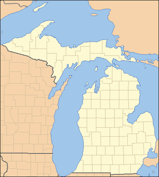
This is a list of properties on the National Register of Historic Places in the U.S. state of Michigan.
This National Park Service list is complete through NPS recent listings posted July 28, 2023.

This is a list of the National Register of Historic Places listings in Saginaw County, Michigan.

The Perin Village Site is an archaeological site in the southwestern part of the U.S. state of Ohio. Located in Newtown in Hamilton County, it is believed to have been inhabited by peoples of the Hopewell tradition.

The Eaker site (3MS105) is an archaeological site on Eaker Air Force Base near Blytheville, Arkansas, that was declared a National Historic Landmark in 1996. The site is the largest and most intact Late Mississippian Nodena phase village site within the Central Mississippi Valley, with archaeological evidence indicating a palisaded village some 50 acres (20 ha) in size, with hundreds of structures. The site's major period of occupation was 1350–1450 CE, although evidence of occupation dates back to 600 CE. The site is also hypothesized to have been occupied by the Quapaw prior to a migration further south, after which they made contact with Europeans in the late 17th century.

The Ashworth Archaeological Site is a significant archaeological site in the extreme southwestern corner of the U.S. state of Indiana. Located near the confluence of the Ohio and Wabash Rivers, it lies near several similar archaeological sites. It was first examined by archaeologists in the middle of the twentieth century and found to be the site of a relatively recent Native American village, and it has been designated a historic site because of its archaeological value.

The Holcombe Site, also known as Holcombe Beach, is a Paleo-Indian archaeological site located near the intersection of Metropolitan Parkway and Dodge Park Road in Sterling Heights, Michigan, United States. It was listed on the National Register of Historic Places in 1971 and designated a Michigan State Historic Site in 1970.
The Sand Point Site is an archaeological site located near Baraga, Michigan. It was listed on the National Register of Historic Places in 1973.

The Summer Island site, designated 20DE4, is an archaeological site located on the northwest side of Summer Island, in Delta County, Michigan. It is classified as a stratified, multi-component site with Middle Woodland, Upper Mississippian and Early Historic/Protohistoric occupations. It was listed on the National Register of Historic Places in 1971.
The Scott Point site, also known as 20MK22 or (erroneously) as the Point Patterson site, is an archaeological site located near the shore of Lake Michigan near Scott Point, south of Gould City, Michigan and west of Point Patterson. It was listed on the National Register of Historic Places in 1976.
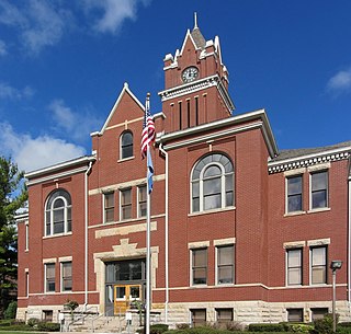
The Antrim County Courthouse is a government building located on South Cayuga Street in Bellaire, Michigan (U.S.). It was designated a Michigan State Historic Site in 1974 and listed on the National Register of Historic Places in 1980. It was designed in 1879, but construction did not begin until 1904. As of 2014, it houses the Antrim County courts and prosecuting attorney.
The Skegemog Point Site, also known as the Samels Field Site or Samels Site and designated 20GT2, is an archaeological site located on the property of the Samels Farm at 8298 Skegemog Point Road, near Williamsburg, Michigan. Material at the site spans over 10,000 years, and the site is unique in that, due to glacial rebound, it is horizontally stratified rather than vertically stratified. The site was listed on the National Register of Historic Places in 1972.

The Spoonville site, also designated 20OT1, is a historic archeological site, located on the banks of the Grand River in Crockery Township, Ottawa County, Michigan, United States. It was placed on the National Register of Historic Places in 1973.
The Wycamp Creek Site is an archaeological site located near Levering, Michigan. It was placed on the National Register of Historic Places in 1971.
The Ponshewaing Point Site is an archaeological site located on Ponshewaing Point in Crooked Lake in Emmet County, Michigan. It was places on the National Register of Historic Places in 1972.

The Hacklander Site, also designated 20AE78, is an archaeological site located on the south shore of the Kalamazoo River east of Douglas, Michigan. It was added to the National Register of Historic Places in 1973. The site is significant because it represents much of what is understood about Woodland period life in the region.

The Mt. McSauba Site, also designated 20CX23, is an archaeological site located near Charlevoix, Michigan. It was listed on the National Register of Historic Places in 1976. The site is an encampment on a dune.

The Fletcher Site, also designated 20BY28, is a Native American cemetery and archaeological site, located on the west bank of the Saginaw River in Bay City, Michigan. It was listed on the National Register of Historic Places in 1971.
The Schultz site and the Green Point Site are two adjacent archaeological sites located near the confluence of the Tittabawassee River and Shiawassee River in Spaulding Township, Michigan. the two sites were listed together on the National Register of Historic Places in 1973.
The Bugai Site, designated 20SA215, is an archaeological site located near Bridgeport, Michigan. It was listed on the National Register of Historic Places in 1982.
The Mahoney Site, designated 20SA193, is an archaeological site located near Bridgeport, Michigan, United States. It was listed on the National Register of Historic Places in 1982.


