Hood's Mill, Maryland

Last updated

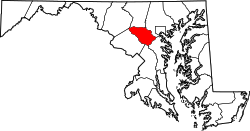
Hood's Mill is an unincorporated community located in Howard County and Carroll County in the state of Maryland in the United States of America.

Unincorporated area Region of land not governed by own local government

In law, an unincorporated area is a region of land that is not governed by a local municipal corporation; similarly an unincorporated community is a settlement that is not governed by its own local municipal corporation, but rather is administered as part of larger administrative divisions, such as a township, parish, borough, county, city, canton, state, province or country. Occasionally, municipalities dissolve or disincorporate, which may happen if they become fiscally insolvent, and services become the responsibility of a higher administration. Widespread unincorporated communities and areas are a distinguishing feature of the United States and Canada. In most other countries of the world, there are either no unincorporated areas at all, or these are very rare; typically remote, outlying, sparsely populated or uninhabited areas.

Howard County, Maryland County in the United States

Howard County is a county in the central part of the U.S. state of Maryland. As of the 2010 census, the population was 287,085. Its county seat is Ellicott City.

Carroll County, Maryland County in the United States

Carroll County is a county located in the U.S. state of Maryland. As of the 2010 census, the population was 167,134. Its county seat is Westminster.

Hood's mill is community formed at the Benjamin Hood's Hood Haven on the Patapsco River. Later Hood's Mill was known as a stop along the B&O railroad with a shipping center run by the Hammond family. [1] [2] [3]

See also

Related Research Articles

Ellicott City, Maryland Census-designated place in Maryland, United States

Ellicott City is an unincorporated community and census-designated place in, and the county seat of, Howard County, Maryland, United States. Part of the Baltimore metropolitan area, its population was 65,834 at the 2010 census, qualifying it as the largest unincorporated county seat in the country.

Patapsco River river in Maryland, United States

The Patapsco River mainstem is a 39-mile-long (63 km) river in central Maryland which flows into the Chesapeake Bay. The river's tidal portion forms the harbor for the city of Baltimore. With its South Branch, the Patapsco forms the northern border of Howard County, Maryland. The name "Patapsco" is derived from the Algonquian pota-psk-ut, which translates to "backwater" or "tide covered with froth."

Oella, Maryland human settlement in Baltimore County, Maryland, United States of America

Oella is a small, historic mill town on the Patapsco River in western Baltimore County, Maryland, located between Catonsville and Ellicott City. It is a 19th-century village of millworkers' homes.

Lansdowne, Maryland Census-designated place in Maryland, United States

Lansdowne is a census-designated place in southern Baltimore County, Maryland, just south of Baltimore city. As of the 2010 census, it had a population of 8,409. At the 2000 census and earlier, the area was delineated as part of the Lansdowne-Baltimore Highlands CDP.

Woodbine, Maryland Unincorporated community in Maryland

Woodbine is an unincorporated rural community in Howard and Carroll counties, Maryland, United States. It is part of the Baltimore metropolitan area. It is located southeast of Frederick, west of Baltimore, north of Washington, D.C., and east of Mount Airy. The community was named for the woodbine plant, which grew in the community in fields and along riverbanks.

St. Charles College (Maryland)

St. Charles College was a minor seminary in Catonsville, Maryland, originally located in Ellicott City, Maryland.

Thomas Viaduct bridge in United States of America

The Thomas Viaduct spans the Patapsco River and Patapsco Valley between Relay, Maryland and Elkridge, Maryland, USA. It was commissioned by the Baltimore and Ohio Railroad (B&O); built between July 4, 1833, and July 4, 1835; and named for Philip E. Thomas, the company's first president.

Ilchester, Maryland Census-designated place in Maryland

Ilchester is an unincorporated community and census-designated place in Howard County, Maryland, United States. The population was 23,476 at the 2010 census. It was named after the village of Ilchester in the English county of Somerset.

Patapsco Valley State Park

Patapsco Valley State Park is a public recreation area extending along 32 miles (51 km) of the Patapsco River south and west of the city of Baltimore, Maryland. The state park encompasses multiple developed areas on over 14,000 acres (5,700 ha) of land. In 2006, it was officially celebrated as Maryland's first state park and is managed by the Maryland Department of Natural Resources.

Woodstock, Maryland Place in Maryland

Woodstock is an unincorporated community which is a suburb of Baltimore, Maryland. The original village of Woodstock is located in Howard County, and also includes portions of Baltimore County and Carroll County.

The Historical Ellicott City/Baltimore Trolley Line #9 Trail is a 1.25-mile (2.0 km) trail in western Baltimore County, Maryland. It begins at the west end of Edmondson Avenue and extends from Catonsville through Oella to Main Street, Ellicott City. The easy-to-walk, shade-covered trail follows what was originally part of the Catonsville and Ellicott City Electric Railway Company trolley line that shuttled passengers between Ellicott City and Baltimore from the late 1890s to the mid-1950s.

Daniels, Maryland Place

Daniels is a ghost town straddling the Patapsco River east of Woodstock and north of Old Ellicott City in Baltimore County and Howard County, Maryland, United States. It is the location of the Daniels Mill, a site listed on the National Register of Historic Places. It is the home town of former Howard County Executive and State Senator James N. Robey. A postal office operated in the community from 1 March 1943 to 31 August 1971.

Lakeland is a neighborhood in south Baltimore, Maryland. Its borders are Annapolis Road on the east, the Baltimore city/county line to the south, a CSX/MARC Railroad line to the west, and the same railroad line to the north.

Bryansville is an unincorporated community in York County, Pennsylvania, United States. The village of Bryansville has a large residential area known as Susquehanna Trails almost adjacent to it. Until 1978, this community was served by the Maryland and Pennsylvania Railroad at milepost 45.9.

Parr's Ridge is a ridge which forms the summit of the Piedmont Plateau region in the U.S. state of Maryland.

The Orange Grove Flour Mill was a flour mill established in 1856. It was one of the leading flour mills in the Mid-Atlantic states until it was destroyed in a fire in 1905.

Daisy, Maryland Place in Maryland

Daisy is an unincorporated community located at the Northwest tip of Howard County, Maryland.

Elkridge Landing

Elkridge Landing was a Patapsco River seaport in Maryland, and is now part of Elkridge, Maryland. The historic Elkridge Furnace Inn site resides within the Patapsco Valley State Park.

Elysville is an unincorporated community in Howard County, Maryland, United States. A postal stop operated between February 22, 1834, and February 3, 1854.

Patapsco Valley

The Patapsco Valley is a small valley surrounding the Patapsco River in central Maryland. The region is known for its historical significance as a major economic and industrial center in the eighteenth and nineteenth centuries.

References

  1. "TO PROTECT WORKMEN: Death Said to Have Been Caused by Flint Dust GOV. BROWN MAKES INVESTIGATIONS The Attention of the Legislature to Be Called to the Process Used by the Patapsco Flint Mill Company at Hood's Mill, Carroll County". The Baltimore Sun. 27 February 1894.
  2. "THROWN INTO A MILL RACE". The Baltimore Sun. 11 May 1893.
  3. Barbara Feaga. Howard's Roads to the Past. p. 57.
Coordinates: 39°21′11″N77°00′56″W / 39.35306°N 77.01556°W / 39.35306; -77.01556

Geographic coordinate system Coordinate system

A geographic coordinate system is a coordinate system that enables every location on Earth to be specified by a set of numbers, letters or symbols. The coordinates are often chosen such that one of the numbers represents a vertical position and two or three of the numbers represent a horizontal position; alternatively, a geographic position may be expressed in a combined three-dimensional Cartesian vector. A common choice of coordinates is latitude, longitude and elevation. To specify a location on a plane requires a map projection.