
Scituate is a town in Providence County, Rhode Island, United States. The population was 10,384 at the 2020 census.

West Warwick is a town in Kent County, Rhode Island, United States. The population was 31,012 at the 2020 census.

Peace Dale is a village in the town of South Kingstown, Rhode Island. Together with the village of Wakefield, it is treated by the U.S. Census as a component of the census-designated place identified as Wakefield-Peacedale, Rhode Island.

The following turnpikes were chartered and built in Rhode Island:
- West Glocester Turnpike 1794
- Providence and Norwich Turnpike 1794
- Rhode Island and Connecticut Turnpike 1803
- Glocester Turnpike 1804
- Providence and Douglass Turnpike 1805
- Rhode Island Turnpike 1805
- Loisquisset Turnpike 1806
- Providence and Pawtucket Turnpike 1807
- Farnum and Providence Turnpike 1808
- Woonasquatucket Turnpike 1810
- Powder Mill Turnpike 1810
- Natick Turnpike 1812
- Valley Falls Turnpike 1813
- Foster and Scituate Turnpike 1813
- Foster and Scituate Central Turnpike 1813
- Coventry and Cranston Turnpike
- Providence and Pawcatuck Turnpike 1816
- Hopkinton and Richmond Turnpike 1820
- Smithfield Turnpike 1823
- Pawtuxet Turnpike 1825
- Mineral Spring Turnpike 1825
- Pawtucket and Providence East Turnpike 1825
- Fall River and Watupper Turnpike 1827
- Stone Bridge and Fall River Turnpike 1838

Fiskeville is a small village in the south west corner of Cranston, Rhode Island, United States, the south east corner of the Town of Scituate, Rhode Island and across the northern side of Coventry, Rhode Island. The village's Main Street forms the border between Cranston and Scituate. Fiskeville grew up as one of several mill towns along the Pawtuxet River in the mid-1800s. The Fiskeville textile mill was formed by Dr. Caleb Fiske, a Revolutionary War doctor turned businessman in 1812. The village became home to those who worked in the mill, mostly immigrants from Portugal, France, Italy and England. Fiskeville is usually associated with Cranston rather than with Scituate as most of the original buildings including Dr. Fiske's residence were in Cranston. Although the mill and about a dozen nearby mill houses were in Scituate. Poets Karen Haskell and Darcie Dennigan both grew up, a few doors down from each other, in the 1970s and 1980s on Main Street in Fiskeville.
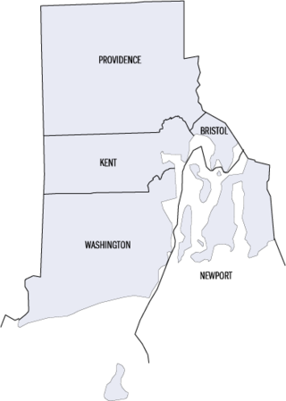
This is a list of properties and districts listed on the National Register of Historic Places in Rhode Island. As of May 29, 2015, there are more than 750 listed sites in Rhode Island. All 5 of the counties in Rhode Island have listings on the National Register.

The Pawtuxet River, also known as the Pawtuxet River Main Stem and the Lower Pawtuxet, is a river in the U.S. state of Rhode Island. It flows 12.3 miles (19.8 km) and empties into the upper Narragansett Bay of the Atlantic Ocean. Together with its two main tributary branches, the North Branch Pawtuxet River and the South Branch Pawtuxet River, it drains a watershed of 231.6 square miles (600 km2), all of which is in the state of R.I.

Pawtuxet Village is a section of the New England cities of Warwick and Cranston, Rhode Island, United States. It is located at the point where the Pawtuxet River flows into the Providence River and Narragansett Bay.

The Scituate Reservoir is the largest inland body of water in the state of Rhode Island. It has an aggregate capacity of 39 billion US gallons (150,000,000 m3) and a surface area of 5.3 square miles (14 km2). It and its six tributary reservoirs—which make up a total surface area of 7.2 square miles (19 km2)—supply drinking water to more than 60 percent of the state population, including Providence.

The North Branch Pawtuxet River is a river in the U.S. state of Rhode Island. It flows approximately 8.9 miles (14.3 km). There are 9 dams along the river's length.

The Furnace Carolina Site is an historic site of a blast furnace in Cumberland, Rhode Island along the Abbott Run river.

Wyoming is a village and census-designated place on the Wood River in southern Rhode Island, primarily in the town of Richmond, Rhode Island, but extending north across the river into the town of Hopkinton, Rhode Island. The population was 270 at the 2010 census. It is the site of the Wyoming Village Historic District and a post office assigned ZIP code 02898.

The Crompton Mill Historic District is a historic district encompassing a mill complex at 20 Remington Street, 53 and 65 Manchester Street in West Warwick, Rhode Island. The mill complex consists of a collection of mainly brick buildings, bounded by the Pawtuxet River and Pulaski, Remington, and Manchester Streets in the village of Crompton. The mill complex formerly extended across the river, but the complex on the west bank was destroyed by fire in 1992. The oldest elements of the complex are the dam site and some of the raceways that provided water power to the mills. The present dam was built in 1908, replacing an 1882 structure. The raceways were built in 1807, around the time of the first mill buildings. The stone Mill No. 1, built 1807, is believed to be the oldest stone mill building in the state. Most of the complex's buildings were built in the late 19th and early 20th centuries by the Providence Manufacturing Company and its successors. The mill was used for textile processing until 1946, when the Crompton Corporation ended production.
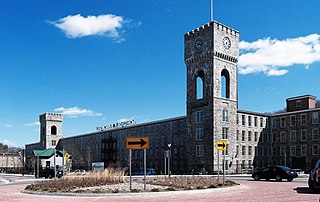
The Royal Mill Complex is an historic textile mill site at 125 Providence Street in West Warwick, Rhode Island. The mill complex was listed on the National Register of Historic Places in 2004. It has recently been completely renovated and remodeled into 250 residential apartments. The complex also includes the Ace Dye Works mill on the south side of the river, which has been converted into lofts. A pedestrian skybridge connects the two mills.

The Valley Queen Mill is an historic mill at 200 Providence Street in West Warwick, Rhode Island.

The Daniel's Village Archeological Site is a historic industrial archaeological site in Killingly, Connecticut. Located in the vicinity of the crossing of Putnam Road and the Five Mile River, the area is the site of one of the earliest textile mills in Connecticut. The mills burned in 1861 and were not rebuilt, ending the village's economic reason to exist. The site was added to the National Register of Historic Places in 1978. The entire site was purchased in 2015 by a historic building expert who has put the original parcel back together. It is now private property.
The city of Woonsocket in the U.S. state of Rhode Island was established as a union of six mill villages along the Blackstone River. These villages are described in more detail below.

Rufus Hopkins was a sailor and businessman who served as a Deputy in the Rhode Island General Assembly from 1772 to 1775, and again from 1781 to 1785.
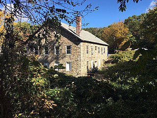
The Otis Angell Gristmill is a historic mill in Governor John Notte Memorial Park, North Providence, Rhode Island. Built about 1855, it is a well-preserved example of a small 19th-century industrial site, with a stone mill building and a small mill pond. The site was added to the National Register of Historic Places in 2017. The mill building now serves as a local community center.

The Manchaug Village Historic District is a historic district encompassing the 19th century industrial village center of Manchaug in Sutton, Massachusetts. Developed in the 1820s around textile mills on the Mumford River, it was the largest industrial area in Sutton, with at least three mill complexes in operation. The district is centered on the junction of Main Street with Manchaug, Putnam Hill, and Whitins Roads.


