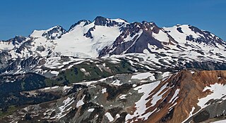
Mount Callaghan is a mountain east of the headwaters of the Squamish River, just northeast of the Powder Mountain Icefield and just south of the Pemberton Icefield in the Sea to Sky Country of southwestern British Columbia, Canada, about 20 km directly west of the Resort Municipality of Whistler. A crack was observed across Callaghan's summit in the spring of 1999. In 2000, a section of the summit collapsed. Callaghan Lake lies below the south face of the mountain.

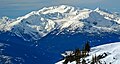
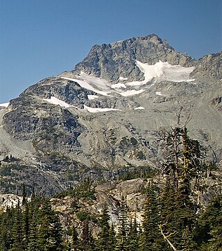
Rainbow Mountain is a broad glaciated mountain forming the northeastern wall of the Callaghan Valley in the Pacific Ranges of British Columbia, Canada. Located in the middle of the Sea to Sky Country, the mountain is just 9 km (5.6 mi) northwest of the resort town of Whistler, and is a popular destination for hiking, snowshoeing and ski touring.
Slalok Mountain, originally known as Rex's Pillar, is a 2,653-metre (8,704-foot) mountain summit located in the Coast Mountains, in Joffre Lakes Provincial Park, in southwestern British Columbia, Canada. It is the third-highest point of the Joffre Group, which is a subset of the Lillooet Ranges. It is situated 24 km (15 mi) east of Pemberton, and 8 km (5 mi) northeast of Lillooet Lake. It is 4 km (2 mi) northeast of Duffey Peak and the nearest higher peak is Mount Matier, 1.9 km (1 mi) to the east. Precipitation runoff from the peak drains into Joffre Creek and Twin One Creek, both tributaries of the Lillooet River. The first ascent of the mountain was made in 1963 by C. Adam, T. Anderson, and G. Richardson. The mountain's name Slalok is the traditional name for the settlement of nearby Mount Currie. The name was officially adopted on June 11, 1979, by the Geographical Names Board of Canada. The mountain and its climate supports the Matier Glacier, Stonecrop Glacier, and Tszil Glacier on the northern slopes.
Cayoosh Mountain is a 2,561-metre (8,402-foot) mountain summit located in the Cayoosh Range in southwestern British Columbia, Canada. It is situated 22 km (14 mi) east-northeast of Pemberton, 12 km (7 mi) north-northeast of Lillooet Lake, and immediately north of Cayoosh Pass. Its nearest higher peak is Mount Marriott, 5.43 km (3 mi) to the north-northeast. Precipitation runoff from the peak drains into Cayoosh Creek and other tributaries of the Fraser River. The mountain's name was submitted by Karl Ricker, a mountaineer, and was officially adopted on January 23, 1979, by the Geographical Names Board of Canada.

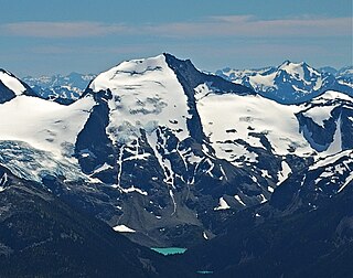
Mount Weart is a 2,835-metre (9,301-foot) triple-summit mountain located in the Garibaldi Ranges of the Coast Mountains, in northwestern Garibaldi Provincial Park of southwestern British Columbia, Canada. It is situated 14 km (9 mi) northeast of Whistler, and its nearest higher peak is Wedge Mountain, 3.7 km (2 mi) to the south, which is the only peak within the park higher than Weart. The Armchair Glacier rests below the west aspect of the summit, and the massive Weart Glacier spans the northern and eastern aspects of the mountain. Precipitation runoff from the peak and meltwater from the glaciers drains into Wedgemount Lake and tributaries of the Lillooet River.
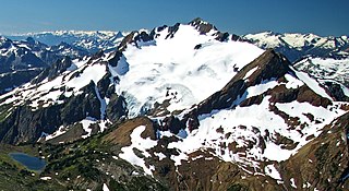
Overlord Mountain is a 2,625-metre (8,612-foot) glacier-clad peak located in the Garibaldi Ranges of the Coast Mountains, in Garibaldi Provincial Park of southwestern British Columbia, Canada. It is the highest point of the Fitzsimmons Range, which is a subset of the Garibaldi Ranges, and can be readily seen from the Whistler Blackcomb ski area. It is situated 15 km (9 mi) southeast of Whistler, and its nearest higher peak is Mount Macbeth, 3 km (2 mi) to the north-northeast. The Benvolio Glacier rests below the south aspect of the summit, the Fitzsimmons Glacier on the east aspect, and the expansive Overlord Glacier spans the northern and western aspects of the mountain. Precipitation runoff from the peak and meltwater from its glaciers drains into tributaries of the Cheakamus River. The first ascent of the mountain was made in 1923 by Phyllis Munday and Don Munday via the Benvolio Glacier. The mountain's descriptive name was recommended by the Garibaldi Park Board and officially adopted on September 2, 1930, by the Geographical Names Board of Canada.

Mount Fitzsimmons is a 2,603-metre (8,540-foot) glacier-clad peak located in the Garibaldi Ranges of the Coast Mountains, in Garibaldi Provincial Park of southwestern British Columbia, Canada. It is the third-highest point of the Fitzsimmons Range, which is a subset of the Garibaldi Ranges. It is situated 15 km (9 mi) southeast of Whistler, and its nearest higher peak is Mount Benvolio, 0.5 km (0 mi) to the west-southwest. The Diavolo Glacier spreads out below the southeast aspect of the summit, and the Fitzsimmons Glacier descends the northwest slopes. Precipitation runoff from the peak and meltwater from its glaciers drains into tributaries of the Cheakamus River. The first ascent of the mountain was made on August 19, 1924, by a party of the British Columbia Mountaineering Club. The peak was named for prospector James Fitzsimmons, who built a trail along Fitzsimmons Creek in an effort to haul supplies to a small copper mine he staked and worked. The mountain's name was officially adopted on September 2, 1930, by the Geographical Names Board of Canada.
Mount Macbeth is a 2,639-metre (8,658-foot) glacier-clad peak located in the Garibaldi Ranges of the Coast Mountains, in Garibaldi Provincial Park of southwestern British Columbia, Canada. It is part of the Spearhead Range, which is a subset of the Garibaldi Ranges. It is situated 14 km (9 mi) southeast of Whistler, and 2 km (1 mi) south of Tremor Mountain, which is the highest point in the Spearhead Range. The Naden Glacier spreads out below the eastern aspect of the summit, the Macbeth Glacier lies below the south aspect, and the Curtain Glacier descends the northern slope. Precipitation runoff from the peak and meltwater from its glaciers drains into Fitzsimmons Creek which is a tributary of the Cheakamus River. Macbeth is most often climbed as part of the Spearhead Traverse. The first ascent of the mountain was made in 1969 by P. Starr, E. Bass, B. Ellis, and P. Macec via the northeast ridge. The peak was named in 1964 by an Alpine Club of Canada climbing party, to commemorate the 400th anniversary of William Shakespeare's birth. The mountain's name was officially adopted on August 27, 1965, by the Geographical Names Board of Canada.

Mount Benvolio is a 2,613-metre (8,573-foot) glacier-clad peak located in the Garibaldi Ranges of the Coast Mountains, in Garibaldi Provincial Park of southwestern British Columbia, Canada. It is the second-highest point of the Fitzsimmons Range, which is a subset of the Garibaldi Ranges. It is situated 15 km (9 mi) southeast of Whistler, and its nearest higher peak is Overlord Mountain, 0.7 km (0 mi) to the northwest. The Benvolio Glacier is set on the western slope of the peak, the Diavolo Glacier spreads out below the eastern aspect of the summit, and the Fitzsimmons Glacier descends the north slope. Precipitation runoff from the peak and meltwater from its glaciers drains into tributaries of the Cheakamus River.

Locomotive Mountain is a 2,340-metre (7,680-foot) mountain summit located in the Railroad Group of the Coast Mountains, in the Pemberton Valley of southwestern British Columbia, Canada. It is situated 35 km (22 mi) northwest of Pemberton, 3 km (2 mi) east of Handcar Peak, and 2.1 km (1 mi) south of Face Mountain, which is the nearest higher neighbor. Precipitation runoff from the peak drains into tributaries of the Fraser River. The mountain's name was proposed in 1978 by mountaineer Karl Ricker of the Alpine Club of Canada, in association with Railroad Pass, Railroad Creek, and other railroad-related names of the immediate vicinity. The toponym was officially adopted January 23, 1979, by the Geographical Names Board of Canada.

Tremor Mountain is a prominent 2,691-metre (8,829-foot) summit located in the Garibaldi Ranges of the Coast Mountains, in Garibaldi Provincial Park of southwestern British Columbia, Canada. It is the highest point of the Spearhead Range, which is a subset of the Garibaldi Ranges. It is situated 13 km (8 mi) southeast of Whistler, and 8.7 km (5 mi) south of Wedge Mountain, its nearest higher peak. Precipitation runoff from the south side of the peak as well as meltwater from the Platform Glacier drains into Fitzsimmons Creek which is a tributary of the Green River. Meltwater from the Tremor Glacier on the northwestern slope drains to Wedge Creek, and meltwater from the Shudder Glacier on the northeast slope drains into Billygoat Creek, a tributary of the Lillooet River. Tremor Mountain is often climbed as part of the Spearhead Traverse. The first ascent of the mountain was made in 1928 by A.J. Campbell Garibaldi survey party. The mountain's name origin refers to unexplained earth tremors when the first ascent party was on the summit. The mountain's toponym was officially adopted on September 6, 1951, by the Geographical Names Board of Canada.
Mount Carr is a 2,590-metre (8,497-foot) mountain summit located in British Columbia, Canada.

Handcar Peak is a 2,338-metre (7,671-foot) mountain summit located in the Railroad Group of the Coast Mountains, in the Pemberton Valley of southwestern British Columbia, Canada. It is situated 38 km (24 mi) northwest of Pemberton and 3 km (2 mi) west of Locomotive Mountain. Precipitation runoff from the peak drains into Sampson Creek and Buck Creek which are both tributaries of the Lillooet River. Handcar Peak is more notable for its steep rise above local terrain than for its absolute elevation as topographic relief is significant with the summit rising over 2,050 meters (6,725 ft) above Lillooet River and Pemberton Valley in approximately 4 km (2.5 mi). The mountain's name was proposed in 1978 by mountaineer Karl Ricker of the Alpine Club of Canada, in association with Railroad Pass, Railroad Creek and other railroad-related names of the immediate vicinity. The toponym was officially adopted January 23, 1979, by the Geographical Names Board of Canada.
Face Mountain is a 2,485-metre (8,153-foot) mountain summit located in British Columbia, Canada.

Phalanx Mountain is a 2,441-metre (8,009-foot) summit located in Garibaldi Provincial Park of southwest British Columbia, Canada.

Goat Peak is a 2,473-metre (8,114-foot) summit located in the Pemberton Valley of British Columbia, Canada.

Mount Howard is a 2,551-metre (8,369-foot) mountain summit located in the Coast Mountains of British Columbia, Canada. It is part of the Joffre Group, which is a subset of the Lillooet Ranges. Mount Howard is situated 27 km (17 mi) east of Pemberton and immediately southeast of Mount Matier. Precipitation runoff from the peak drains into Twin One Creek thence Lillooet Lake which is within the Lillooet River watershed. Mount Howard is more notable for its steep rise above local terrain than for its absolute elevation as topographic relief is significant with the summit rising 1,650 meters (5,413 ft) above Twin One Creek in 4 km (2.5 mi).
Rhododendron Mountain is a 2,523-metre (8,278-foot) glaciated summit in British Columbia, Canada.

Cloudraker Mountain is a 2,385-metre (7,825-foot) glaciated summit in British Columbia, Canada.
Whitecap Mountain is a 2,918-metre (9,573-foot) summit in British Columbia, Canada.