
Barrington is a suburban, residential town in Bristol County, Rhode Island, United States, approximately 7 miles (11 km) southeast of Providence. As of the 2020 United States Census, the population was 17,153.
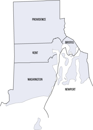
This is a list of properties and districts listed on the National Register of Historic Places in Rhode Island. As of May 29, 2015, there are more than 750 listed sites in Rhode Island. All 5 of the counties in Rhode Island have listings on the National Register.

Lime Rock (Limerock) is a village and historic district in Lincoln, Providence County, Rhode Island, United States, near Rhode Island Route 146. The village was named after the limestone quarries in the area, which started in the 17th century, and continue to the present where Conklin Limestone Company now operates. Because of the abundance of limestone in the area many houses had massive end chimneys and were called "stone enders," a distinctly Rhode Island style of architecture. The historic district includes 21 historically significant properties in an area extending from Wilbur Road, just west of its junction with Old Louisquisset Pike, eastward to Great Road, and then along Great Road as far as Simon Sayles Road. Among these properties are three quarries, and the ruins of three old lime kilns. It was listed on the National Register of Historic Places in 1974.

The Alfred Drowne Road Historic District of Barrington, Rhode Island, encompasses a suburban area developed between about 1860 and 1910, a period of significant suburban growth in Barrington spurred by the connection of the town by rail to Providence in 1855. This 27-acre (11 ha) residential area was before that time farmland owned by Alfred Drown, whose c. 1830 farmhouse still stands at 13 Alfred Drowne Road. The house of his son Benjamin, built c. 1856, is at number 27. The district includes properties along Alfred Drowne Road, as well as a few properties on Washington Street and Annawamscutt Road which are immediately adjacent.

Barrington Civic Center Historic District is a historic district in Barrington, Rhode Island on County Road. The district, which consists of the Barrington Town Hall, Leander R. Peck School and Prince's Hill Cemetery, is located on Prince's Hill near the center of Barrington. In 1728, Prince's Hill Cemetery was purchased and later expanded to its present size by 1898. The 1+1⁄2-story Barrington Town Hall was completed in 1888 and originally served as the seat of the town's government, library and high school. With the completion of the Leander R. Peck School in 1917, the high school moved into the adjacent building and the library used its space. The two-story Elizabethan Revival style Peck School is designed with a T-shaped plan and features a stairway to access the main entrance on the second story. The Peck School was later used by the fifth and sixth-grade elementary students before becoming the public library. Also located within the district is Wood's Pond. The Barrington Civic Center Historic District was added to the National Register of Historic Places in 1976 and serves as a historically significant example of civic and natural environment planning of the late nineteenth century.

Nayatt Point Light is a historic lighthouse in Barrington, Rhode Island.

St. Matthew's Episcopal Church is a historic Episcopal church located at 5 Chapel Road in Barrington, Rhode Island. It is an active parish in the Episcopal Diocese of Rhode Island.

The Jamestown Windmill is a smock mill in Jamestown, Rhode Island within the Windmill Hill Historic District on North Road north of Weeden Lane.

The Little Compton Commons Historic District, or Little Compton Commons, is a historic district in Little Compton, Rhode Island. It is a triangular area roughly bounded by School House Lane to the north, South Commons Road to the east, and Meeting House Lane to the south. Properties continue to the west on West Road.
The Bicknell–Armington Lightning Splitter House is a historic house at 3591 Pawtucket Avenue in East Providence, Rhode Island. The house is of a distinctive type, a "Lightning Splitter", of which only a few instances exist in the Providence area. It is a wood-frame structure with a steep two-story gable roof. Records suggest that the house was constructed about 1827, but architectural evidence suggests it was extensively altered in the 1850s. The main entrance and the interior has a simplified Greek Revival styling. The house was listed on the National Register of Historic Places on November 28, 1980.

The Wanskuck Historic District is a historic district in the city of Providence, Rhode Island encompassing a mill village with more than two hundred years of history. As early as the mid-18th century, mills stood on the West River in northern Providence, a development which continued with the rise of industrialization in the 19th century. The mill village of Wanskuck is organized around three thoroughfares: Branch Street, Veazie Street, and Woodward Road, and is roughly bounded on the east by Louisquisset Pike and to the northwest by the city line with North Providence. The West River runs through the district, with its banks lined by two late-19th-century mill complexes. The village area includes a variety of examples of mill worker housing, from duplexes to rowhouses, as well as two church complexes and a community hall built in 1884 by the Wanskuck Company.

The Davisville Historic District is a historic district on Davisville Road in Davisville, Rhode Island, a village in North Kingstown. It encompasses the site of an early 19th-century mill, and several associated buildings, including five houses dating to the 18th or 19th century and a cemetery. It is located on either side of Davisville Road, between the Hunt River and Olde Mill Lane.

The Hamilton Mill Village Historic District is a historic district encompassing a small mill village in North Kingstown, Rhode Island. It is located on the south side of the Annaquatucket River, near its mouth at Bissell Cove. The village includes two wood-frame mill buildings and a collection of mill worker housing units, which line a short section of Boston Neck Road as well as Salisbury Avenue, Web Avenue, and Martha Road. The most impressive mill building is the main mill, built in 1853 and enlarged in 1866 with a double clerestory roof, something not found in other surviving mills in the state.

Tillinghast Road Historic District is a historic district encompassing a rural landscape in East Greenwich, Rhode Island. Extending along Tillinghast Road, a winding two-lane road, southward from its junction with Frenchtown Road, it includes seven farm complexes dating back to the late 18th and early 19th centuries. One of them, the Thomas Tillinghast Farm, located at the above-named junction, is the site of the New England Wireless and Steam Museum, some of whose buildings contribute to the district's significance.

The Conanicut Friends Meetinghouse is a historic Quaker meeting house at the junction of North Road and Weeden Lane in Jamestown, Rhode Island.

The Benjamin Aborn Jackson House is an historic house at 115 Nayatt Road in Barrington, Rhode Island. The 2+1⁄2-story brick house was designed by architect Norman M. Isham and completed in 1913 for Benjamin Aborn Jackson, a Rhode Island banking and railroad executive. The house is a rare survivor of the development of Nayatt Point as a resort area. The L-shaped building is set well back from Nayatt Road, and is not far from the Nayatt Point Light.

Hopkins Hollow Village is an historic district along Hopkins Hollow Road, Narrow Lane, and Perry Hill Road in Coventry, Rhode Island, United States, and West Greenwich, Rhode Island.

The Allen–West House is an historic house at 153 George Street in Barrington, Rhode Island. The main block of the two story timber-frame house was built c. 1763 by Joseph Allen, a housewright. It is one of the older houses in Barrington, hearkening to the days when it was still part of Swansea, Massachusetts, and is a well-preserved rare example of a vernacular square house plan. The house stands amid grounds that were farmed from the 17th to the 20th centuries by the owners of this house, who included members of the Allen family until the mid-19th century, and the Wests until the mid-20th. The house has had two major additions: a kitchen ell added to the east in the 19th century and extended in the 1950s, and a c. 1920s single-story enclosed porch on the west side.

The Shoreby Hill Historic District encompasses a major residential subdivision north of the central business district of Jamestown, Rhode Island. The 58-acre (23 ha) district was farmland until the late 19th century, and was laid out in two phases. The first, in 1898 includes the lower portion of the area, rising from the shore of Jamestown Harbor; the upper portion was laid out in 1911. The lower portion's layout is in part determined by its hill topography, with winding roads, while the upper portion has a more rectilinear grid street pattern. The district is roughly bounded on the east by Jamestown Harbor, on the north by Emerson Road, Prudence Lane, and Whittier Road, on the west by Plymouth Road, and Coronado Street, and on the south by Knowles Court. The area was designed by Ernest W. Bowditch as an exclusive and fashionable summer resort area, with larger houses on well-proportioned lots. The ninety houses in the district are predominantly shingle style.
The following properties and districts in Barrington, Rhode Island, are on the National Register of Historic Places.


