Jimbour Dry Stone Wall

Last updated

Jimbour Dry Stone Wall
Jimbour Dry Stone Wall.jpg
Jimbour Dry Stone Wall, 2011
LocationDalby-Jandowae Road, Jimbour East, Western Downs Region, Queensland, Australia
Coordinates 26°56′57″S151°17′07″E / 26.9491°S 151.2854°E / -26.9491; 151.2854 Coordinates: 26°56′57″S151°17′07″E / 26.9491°S 151.2854°E / -26.9491; 151.2854
Design period1840s - 1860s (mid-19th century)
Builtcirca 1870s
Official nameJimbour Dry Stone Wall
Typestate heritage (landscape, built)
Designated31 May 2005
Reference no.602415
Significant period1870s (historical)
Significant componentswall/s
Australia Queensland location map.svg
Red pog.svg
Location of Jimbour Dry Stone Wall in Queensland

Jimbour Dry Stone Wall is a heritage-listed stone wall at Dalby-Jandowae Road, Jimbour East, Western Downs Region, Queensland, Australia. It was built circa 1870s. It is an example of the expertise of the settlers and management tools they had at the time. It was added to the Queensland Heritage Register on 31 May 2005. [1]

Contents

History

The Jimbour Dry Stone Wall is located on a low, stony ridge to the north of Jimbour Homestead, the former head station on the once expansive Jimbour pastoral run on the Darling Downs. The wall was constructed most likely during the 1870s, apparently as a barrier to prevent sheep from crossing the stony ridge, to keep dingoes from preying on the sheep and to prevent wallabies from destroying crops planted in paddocks close to the head station. [1]

Dry stone walling is an ancient craft using stone with no mortar to construct a wall. It gained popularity in Britain during the late 18th and early 19th centuries during the enclosure movement and the practice was introduced to Australia during the mid-1800s. Traditionally each dry stone wall was constructed by laying two parallel outer walls of stones, which tapered inwards towards the top; filling the space between with smaller stones and rubble; then laying coping stones across the top to complete the wall. Dry stone walls were labour-intensive to construct and repair, but in areas where stone was readily available, for early land owners they could prove economical and more durable than timber fences, requiring less maintenance and being fireproof. For European settlers the walls also transformed the landscape into something that resembled their native homes, a process that has been described by one scholar as "colonisation by mimesis" and "a type of ground clearing that instituted one type of memorialisation over another". [1]

In 1863/64 Messrs Bell & Sons, the pastoral lessees of Jimbour run, applied under right of pre-emptive purchase for the freehold of nine portions of land along Jimbour Creek and around Jimbour head station. Pre-emptive portion one included the eastern end of the Jimbour Ridge. The survey plan (D35119) on which this application was based and dated 2 January 1864, shows a number of timber fences across the property, but not a stone wall (or any type of fence) along the Jimbour Ridge. Certificate of title to these portions was granted to Messrs Bell & Sons in 1864. [1]

With security of tenure, the Bells made extensive improvements on the Jimbour freehold during the 1870s. Stately Jimbour House, Queensland's grandest 19th century homestead, was erected 1874-77 and the dry stone wall was constructed likely around the same time, in a period when the station reached its peak as a 19th-century pastoral enterprise. [1]

Following the extensive restoration of Jimbour House in 1925, The Queenslander newspaper printed a story about the property to celebrate the formal re-opening of the house. The article, written from notes by Harry Ensor, Joshua Peter Bell's overseerer, "right hand man" and building supervisor at Jimbour during the 1870s, records that the first plan was to build a log fence on the Jimbour Ridge, but the idea was abandoned due to the abundance of available stone. Instead, a dry stone wall was built for a length of about 4 miles (6.4 km). This wall was about 5 feet (1.5 m) high, 2 feet 6 inches (0.76 m) wide at the base and 18 inches (460 mm) wide at the top. Dubbed the "Great Wall of Jimbour", its construction proved to be a feat of human perseverance. The stony ground of the ridge meant that bullocks needed to be continuously shod and the workmen were forced to lace greenhide to their boots. The difficult terrain and extent of the wall would have made it a time-consuming task. Ensor recalled that the work gang leader, who first thought of the idea and supervised construction of the wall, became affectionately known as "Stonewall Jackson". [1]

Ensor also claimed that the dry stone wall was built to divide the Jimbour run. It is not clear what is meant by this comment. An 1877 survey plan (A3441005 drawn by surveyor Martin Lavelle) of further Jimbour pre-emptive purchases shows the dry stone wall extending the length of a stony ridge (the Jimbour Ridge) to the north east of the station residence. By this time it appears the wall had been in place for several years, with the surveyor noting that the wall was in "a bad state being full of grass". However, the wall was not used as a boundary for any of the portions surveyed. [1]

It seems more plausible that the wall was constructed as a barrier fence. Jimbour in the 1870s was a large sheep station still employing shepherds to manage the flocks. The stony ground of the ridge on which the wall was built would have been difficult to patrol on foot and Harry Ensor recollected how the "grass was on many occasions higher than the sheep" making it difficult to shepherd them. The stone wall was constructed to the traditional height required to enclose sheep and it seems likely the purpose of the wall was to prevent flocks wandering over the grassy ridge at a time when Jimbour suffered from a dingo problem. [1]

The stone wall may also have served a supplementary purpose of keeping wallabies away from the plains adjacent to the head station where blue grass and wild oats grew. In the late 19th century wallabies were a persistent problem for land owners on the Darling Downs, who were forced to erect fences in an effort to control their movements. An 1874 Brisbane Courier report on Darling Downs selections around Jandowae noted "thousands of wallabies" had become pests in the region and that fences were being constructed "for the sole purpose of shutting in these little grass devourers" . At Jimbour, wallabies were no less of a problem. In 1882 the Land Commissioner for the Darling Downs reported to the Lands Department that portions of Jimbour were "rendered almost useless by reason of being overrun with wallaby". [1]

With the repurchase of Jimbour in the early 20th century and subsequent 1909 subdivision of land either side of the Jimbour Ridge for closer agricultural settlement, the dry stone wall was used as the approximate demarcation line for subdivisions north and south of the wall. The 1909 surveys cross and re-cross the wall many times, but the survey lines mostly follow within a few metres of the stone wall. Despite sections of the wall being today in a state of collapse where wallabies have created trails over the wall, other sections remain in a relatively well-preserved state and stand as a testimony to the skills and tenacity of early pastoral workers in Queensland. [1]

Description

The Jimbour Dry Stone Wall is located on the Jimbour Ridge, a low, open, grassy but stony ridge to the north of Jimbour House and is constructed of scattered volcanic rocks taken from this ridge. Its construction type is a random double wall, being two outer skins (walls) of irregularly shaped stones, not laid in courses, which taper inwards. The space between has been filled with smaller stone rubble. [1]

The wall extends an approximate length of 6.5 kilometres (4.0 mi). Some sections remain in an original state and stand to an approximate height of 1.5 metres (4 ft 11 in). Other sections have collapsed to the foundation stones and the first layers of building stones and stand to a height between 50 and 70 centimetres (20 and 28 in). [1]

In these deteriorated sections of the wall sapling posts or (in a small section) steel posts have been inserted to support wire mesh and barbed wire. These posts appear to have been inserted by removing the outer facing stones of one side of the wall, placing the posts in position, then replacing the outer stones to secure the posts. [1]

Heritage listing

Jimbour Dry Stone Wall was listed on the Queensland Heritage Register on 31 May 2005 having satisfied the following criteria. [1]

The place is important in demonstrating the evolution or pattern of Queensland's history.

The dry stone wall at Jimbour was most likely constructed in the 1870s as a barrier fence, at a period when Jimbour Station was one of Queensland's largest pastoral enterprises. It is important in demonstrating the evolution or pattern of Queensland's history insofar as it provides evidence of traditional European technology used by early settlers in controlling, shaping and adapting to the Queensland landscape. [1]

The place demonstrates rare, uncommon or endangered aspects of Queensland's cultural heritage.

Dry stone walls of this size and extent are scarce in Queensland and the Jimbour Dry Stone Wall provides a relatively well-preserved example of a rare, uncommon or endangered aspect of Queensland's cultural heritage. [1]

The place is important in demonstrating the principal characteristics of a particular class of cultural places.

It stands as a testimony to the tenacity and skills of early pastoral workers and is important in demonstrating the principal characteristics of a traditional form of wall construction, dry stone walling, transplanted to Queensland in the 19th century. [1]

Related Research Articles

Darling Downs Region in Queensland, Australia

The Darling Downs is a farming region on the western slopes of the Great Dividing Range in southern Queensland, Australia. The Downs are to the west of South East Queensland and are one of the major regions of Queensland. The name was generally applied to an area approximating to that of the Condamine River catchment upstream of Condamine township but is now applied to a wider region comprising the Southern Downs, Western Downs, Toowoomba and Goondiwindi local authority areas. The name Darling Downs was given in 1827 by Allan Cunningham, the first European explorer to reach the area and recognises the then Governor of New South Wales, Ralph Darling.

Bell, Queensland Town in Queensland, Australia

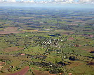
Bell is a rural town and locality in the Western Downs Region, Queensland, Australia. It is in the western foothills of the Bunya Mountains, 39 kilometres (24 mi) north of Dalby. At the 2016 census, Bell had a population of 502.

Canning Downs

Canning Downs was the first residential establishment built by a white person on the Darling Downs in Queensland, Australia. It is located a short drive from the town of Warwick and originally extended south east to Killarney and the McPherson Range. The area was first named after the British statesman George Canning by Allan Cunningham.

Jimbour, Queensland Town in Queensland, Australia

Jimbour is a town in the locality of Jimbour East, Western Downs Region, Queensland, Australia.

Jimbour Homestead

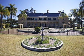
Jimbour is a heritage-listed homestead on one of the earliest stations established on the Darling Downs, Queensland, Australia, It is important in demonstrating the pattern of early European exploration and pastoral settlement in Queensland, Australia. The building is associated with the development of the Darling Downs and of the pastoral industry in Queensland and is important in demonstrating the wealth and ambition of early Queensland pastoralists.

Jondaryan Woolshed

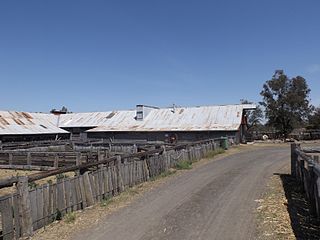
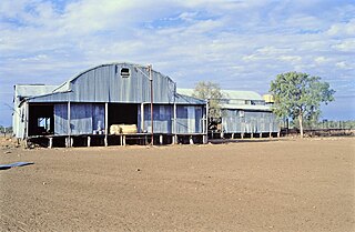
Jondaryan Woolshed is a heritage-listed shearing shed at Evanslea Road, Jondaryan, Queensland, Australia. It was built in 1859-60 to replace an earlier, smaller woolshed on the former Jondaryan pastoral station, which was at one stage the largest freehold station in Queensland. The woolshed was the scene of significant labour conflict in the late 1880s and early 1890s, as the station became a test case for the new Queensland Shearers Union in the lead-up to the 1891 Australian shearers' strike.

Jondaryan Homestead

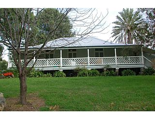
Jondaryan Homestead is a heritage-listed homestead at Evanslea Road, Jondaryan, Toowoomba Region, Queensland, Australia. It was the base of the former Jondaryan pastoral station, which was originally taken up in 1840, and at one time was the largest freehold station in Queensland. The site contains the current house, which was built after the original was destroyed by fire in 1937, the original kitchen dating from 1844, and a kitchen, butcher's shop, shearer's quarters, stables, dairy, toilet block and store, many dating from the 1860s. It also contains the remains of horse stalls, a slaughterhouse, hide store, and Chinese gardener's glasshouse. It was added to the Queensland Heritage Register on 21 October 1992.

Fassifern Homestead

Fassifern Homestead is a heritage-listed homestead at 1008B Boonah-Fassifern Road, Kalbar, Scenic Rim Region, Queensland, Australia. It was built circa 1880. It was added to the Queensland Heritage Register on 13 November 2008.

Talgai Homestead

Talgai Homestead is a heritage-listed homestead at Allora, Southern Downs Region, Queensland, Australia. It was designed by architect Richard George Suter for Queensland pastoralist and politician George Clark and was built in 1868. It was added to the Queensland Heritage Register on 21 August 1992. It is also known as East Talgai Homestead to distinguish it from the West Talgai Homestead built by Clark's brother, Charles Clark.

Ballandean Homestead

Ballandean Homestead is a heritage-listed homestead at Ballandean, Southern Downs Region, Queensland, Australia. It was built from c. 1840 to 1890s circa. It was added to the Queensland Heritage Register on 21 October 1992.

Glengallan Homestead

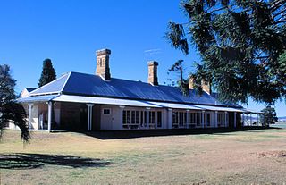
Glengallan Homestead is a heritage-listed homestead on the New England Highway, Glengallan, Southern Downs Region, Queensland, Australia. It was built from 1864 to 1904. It is also known as Glengallan Head Station. It was added to the Queensland Heritage Register on 21 October 1992 and is open to the public.

Stonehouse, Moore

Stonehouse is a heritage-listed former homestead and inn on the D'Aguilar Highway, Moore, Somerset Region, Queensland, Australia. It was built from c. 1874 to 1888. It was added to the Queensland Heritage Register on 25 October 2002.

Burrandowan Station Homestead

Burrandowan Station Homestead is a heritage-listed homestead at Kingaroy Road, Durong, South Burnett Region, Queensland, Australia. It was built from 1848 to c. 1927. It was added to the Queensland Heritage Register on 21 October 1992.

Old Rainworth Stone Store

Old Rainworth Stone Store is a heritage-listed storehouse and now museum at Wealwandangie Road, Cairdbeign, 10 kilometres (6.2 mi) south of the town of Springsure, Central Highlands Region, Queensland, Australia. It was built in 1862 by George Goldring. It is also known as Old Rainworth Fort and Rainworth Head Station Store. It was added to the Queensland Heritage Register on 21 October 1992.

The Glebe Homestead

The Glebe Homestead is a heritage-listed homestead at Taroom-Cracow Road, Glebe near Taroom, Shire of Banana, Queensland, Australia. It was designed by Florence Mary Rigby and built c. 1920. It is also known as Broadwater. It was added to the Queensland Heritage Register on 23 March 2007.

Taromeo Station

Taromeo Station is a pastoral farm off the D'Aguilar Highway, Benarkin, South Burnett Region, Queensland, Australia. It was built from 1854 to the 1860s. It is also contains the Taromeo cemetery. The Taromeo Homestead and its cemetery were added to the Queensland Heritage Register on 21 October 1992.

Boondooma Homestead

Boondooma Homestead is a heritage-listed homestead at Mundubbera - Durong Road, Boondooma, South Burnett Region, Queensland, Australia. It was built from the 1850s to the 1870s. It was added to the Queensland Heritage Register on 21 October 1992.

Darr River Downs

Darr River Downs is a heritage-listed homestead at Landsborough Highway, Morella, Longreach Region, Queensland, Australia. It was built from 1870s circa to 1900s circa. It was added to the Queensland Heritage Register on 27 June 2003.

Jimbour East, Queensland Suburb of Western Downs Region, Queensland, Australia

Jimbour East is a locality in the Western Downs Region, Queensland, Australia. In the 2006 census, Jimbour East had a population of 185 people.

Jimbour West, Queensland Suburb of Western Downs Region, Queensland, Australia

Jimbour West is a locality in the Western Downs Region, Queensland, Australia. In the 2016 census, Jimbour West had a population of 56 people.

References

  1. 1 2 3 4 5 6 7 8 9 10 11 12 13 14 15 16 17 "Jimbour Dry Stone Wall (entry 602415)". Queensland Heritage Register . Queensland Heritage Council. Retrieved 1 August 2014.

Attribution

CC-BY-icon-80x15.png This Wikipedia article incorporates text from "The Queensland heritage register" published by the State of Queensland under CC-BY 3.0 AU licence (accessed on 7 July 2014, archived on 8 October 2014). The geo-coordinates were computed from the "Queensland heritage register boundaries" published by the State of Queensland under CC-BY 3.0 AU licence (accessed on 5 September 2014, archived on 15 October 2014).

Further reading

Davis, Michael T.; University of Tasmania (20 March 2006), The Great Wall of Jimbour: Heritage and the Cultural Landscape, University of Technology, Sydney, retrieved 30 October 2013

Commons-logo.svg Media related to Jimbour Dry Stone Wall at Wikimedia Commons