Johnsville, California

Last updated
Johnsville
Plumas County California Incorporated and Unincorporated areas Johnsville Highlighted.svg
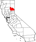
Location in Plumas County and the state of California
Usa edcp location map.svg
Red pog.svg
Johnsville
Location in the United States
Coordinates: 39°46′46″N120°41′38″W / 39.77944°N 120.69389°W / 39.77944; -120.69389
Country Flag of the United States.svg  United States
State Flag of California.svg  California
County Plumas
Area
[1]
  Total13.808 sq mi (35.764 km2)
  Land13.756 sq mi (35.629 km2)
  Water0.052 sq mi (0.135 km2)  0.38%
Elevation
5,180 ft (1,579 m)
Population
 (2010)
  Total20
  Density1.5/sq mi (0.6/km2)
Time zone UTC-8 (Pacific (PST))
  Summer (DST) UTC-7 (PDT)
ZIP code
96103
Area code 530
FIPS code 06-37512
GNIS feature ID1658869

Johnsville is a census-designated place (CDP) in Plumas County, California, United States. The population was 20 at the 2010 census, down from 21 at the 2000 census.

Contents

Geography

Johnsville is located at 39°46′46″N120°41′38″W / 39.77944°N 120.69389°W / 39.77944; -120.69389 (39.779359, -120.693855). [2]

According to the United States Census Bureau, the CDP has a total area of 13.8 square miles (36 km2), of which, 13.8 square miles (36 km2) of it is land and 0.1 square miles (0.26 km2) of it (0.38%) is water.

Demographics

Historical population
CensusPop.Note
U.S. Decennial Census [3]

2010

The 2010 United States Census [4] reported that Johnsville had a population of 20. The population density was 1.4 inhabitants per square mile (0.54/km2). The racial makeup of Johnsville was 20 (100.0%) White, 0 (0.0%) African American, 0 (0.0%) Native American, 0 (0.0%) Asian, 0 (0.0%) Pacific Islander, 0 (0.0%) from other races, and 0 (0.0%) from two or more races. Hispanic or Latino of any race were 0 persons (0.0%).

The Census reported that 20 people (100% of the population) lived in households, 0 (0%) lived in non-institutionalized group quarters, and 0 (0%) were institutionalized.

There were 11 households, out of which 0 (0%) had children under the age of 18 living in them, 8 (72.7%) were opposite-sex married couples living together, 0 (0%) had a female householder with no husband present, 0 (0%) had a male householder with no wife present. There were 0 (0%) unmarried opposite-sex partnerships, and 0 (0%) same-sex married couples or partnerships. 3 households (27.3%) were made up of individuals, and 0 (0%) had someone living alone who was 65 years of age or older. The average household size was 1.82. There were 8 families (72.7% of all households); the average family size was 2.13.

The population was spread out, with 0 people (0%) under the age of 18, 1 people (5.0%) aged 18 to 24, 0 people (0%) aged 25 to 44, 14 people (70.0%) aged 45 to 64, and 5 people (25.0%) who were 65 years of age or older. The median age was 57.5 years. For every 100 females, there were 122.2 males. For every 100 females age 18 and over, there were 122.2 males.

There were 103 housing units at an average density of 7.5 per square mile (2.9/km2), of which 10 (90.9%) were owner-occupied, and 1 (9.1%) were occupied by renters. The homeowner vacancy rate was 9.1%; the rental vacancy rate was 0%. 18 people (90.0% of the population) lived in owner-occupied housing units and 2 people (10.0%) lived in rental housing units.

2000

As of the census [5] of 2000, there were 21 people, 12 households, and 3 families residing in the CDP. The population density was 1.5 inhabitants per square mile (0.58/km2). There were 71 housing units at an average density of 5.2 per square mile (2.0/km2). The racial makeup of the CDP was 80.95% White, 4.76% Asian, 14.29% from other races. 14.29% of the population were Hispanic or Latino of any race.

There were 12 households, out of which 16.7% had children under the age of 18 living with them, 25.0% were married couples living together, and 75.0% were non-families. 66.7% of all households were made up of individuals, and 8.3% had someone living alone who was 65 years of age or older. The average household size was 1.75 and the average family size was 3.67.

In the CDP, the population was spread out, with 19.0% under the age of 18, 4.8% from 18 to 24, 23.8% from 25 to 44, 47.6% from 45 to 64, and 4.8% who were 65 years of age or older. The median age was 46 years. For every 100 females, there were 90.9 males. For every 100 females age 18 and over, there were 112.5 males.

The median income for a household in the CDP was $6,042, and the median income for a family was $0. Males had a median income of $0 versus $48,750 for females. The per capita income for the CDP was $8,030. There are 100.0% of families living below the poverty line and 86.5% of the population, including 100.0% of under eighteens and none of those over 64.

Politics

In the state legislature, Johnsville is in the 1st Senate District , represented by Republican Brian Dahle, [6] and the 1st Assembly District , represented by Republican Megan Dahle. [7]

Federally, Johnsville is in California's 1st congressional district , represented by Republican Doug LaMalfa. [8]

Notable people

Related Research Articles

<span class="mw-page-title-main">Mesa Vista, California</span> Census-designated place in California, United States

Mesa Vista is a census-designated place (CDP) in Alpine County, California, United States. The population was 200 at the 2010 census, up from 182 at the 2000 census.

<span class="mw-page-title-main">Round Valley, California</span> Census-designated place in California, United States

Round Valley is a census-designated place (CDP) in Inyo County, California, United States. Round Valley is located 7.5 miles (12 km) northeast of Mount Tom, at an elevation of 4692 feet. The population was 435 at the 2010 census, up from 278 at the 2000 census.

<span class="mw-page-title-main">Derby Acres, California</span> Census-designated place in California, United States

Derby Acres is a census-designated place (CDP) in Kern County, California, United States. Derby Acres is located 5.5 miles (8.9 km) north-northwest of Fellows, at an elevation of 1,375 feet (419 m). The population was 322 at the 2010 census, down from 376 at the 2000 census. The town is on State Route 33 at the northern extremity of the Midway-Sunset Oil Field, about five miles (8 km)five miles southeast of McKittrick.

<span class="mw-page-title-main">Valley Acres, California</span> Census-designated place in California, United States

Valley Acres is a census-designated place (CDP) in Kern County, California, United States. Valley Acres is located 5.2 miles (8.4 km) north-northeast of Taft, at an elevation of 420 feet (128.02 m). The population was 527 at the 2010 census, up from 512 at the 2000 census.

<span class="mw-page-title-main">Lagunitas-Forest Knolls, California</span> Census-designated place in California, United States

Lagunitas-Forest Knolls is a census-designated place, composed of two unincorporated areas in the western half of the San Geronimo Valley in Marin County, California. It is located to the west of San Geronimo and Woodacre. The population was 1,924 at the 2020 census.

<span class="mw-page-title-main">Lake of the Pines, California</span> Census-designated place in California, United States

Lake of the Pines is a census-designated place (CDP) and a gated residential community in Nevada County, California, United States. The population was 3,917 at the 2010 census.

<span class="mw-page-title-main">Blairsden, California</span> Census-designated place in California, United States

Blairsden is a census-designated place (CDP) in Plumas County, California, United States. Blairsden is located 20 miles (32.2 km) east-southeast of Quincy. The population was 39 at the 2010 census, down from 50 at the 2000 census.

<span class="mw-page-title-main">Mohawk Vista, California</span> Census-designated place in California, United States

Mohawk Vista is a census-designated place in Plumas County, California, United States. The population was 159 at the 2010 census, up from 121 at the 2000 census.

<span class="mw-page-title-main">Taylorsville, California</span> Census-designated place in California, United States

Taylorsville is a census-designated place (CDP) in Plumas County, California, United States. The population was 150 at the 2010 census, down from 154 at the 2000 census. The annual Stone Ranch Reunion is held in Taylorsville.

<span class="mw-page-title-main">Lenwood, California</span> Census-designated place in California, United States

Lenwood is a census-designated place (CDP) in the Mojave Desert near Barstow, in San Bernardino County, California.

<span class="mw-page-title-main">Grenada, California</span> Census-designated place (CDP) in Siskiyou County, California, United States

Grenada is a census-designated place (CDP) in Siskiyou County, California, United States. Its population is 314 as of the 2020 census, down from 367 from the 2010 census. The ZIP code is 96038 and the community is within area code 530.

<span class="mw-page-title-main">Tennant, California</span> Census-designated place in California

Tennant is a census-designated place (CDP) in Siskiyou County, California, United States. Its population is 63 as of the 2020 census, up from 41 from the 2010 census.

<span class="mw-page-title-main">Park View, Iowa</span> CDP in Iowa, USA

Park View is a census-designated place (CDP) in Scott County, Iowa, United States. The population was 2,389 at the 2010 census.

<span class="mw-page-title-main">Greycliff, Montana</span> CDP in Montana, United States

Greycliff is a census-designated place (CDP) in Sweet Grass County, Montana, United States. The population was 56 at the 2000 census.

<span class="mw-page-title-main">Heathcote, New Jersey</span> Census-designated place in New Jersey, United States

Heathcote is an unincorporated community and census-designated place (CDP) located within South Brunswick Township, in Middlesex County, in the U.S. state of New Jersey. As of the 2010 United States Census, the CDP's population was 5,821.

<span class="mw-page-title-main">Old Bridge (CDP), New Jersey</span> Census-designated place in New Jersey, United States

Old Bridge is a census-designated place (CDP) in Old Bridge Township, in Middlesex County, in the U.S. state of New Jersey. As of the 2010 United States Census, the CDP's population was 23,753. Despite the similarity in the name of the CDP and the township, the two are not one and the same, as had been the case for most paired Township / CDP combinations prior to the 2010 Census, in which the CDP was coextensive with a township of the same name.

<span class="mw-page-title-main">Barnegat (CDP), New Jersey</span> Populated place in Ocean County, New Jersey, US

Barnegat is an unincorporated community and census-designated place (CDP) located within Barnegat Township, in Ocean County, in the U.S. state of New Jersey. As of the 2010 United States census, the CDP's population was 2,817.

<span class="mw-page-title-main">Cedar Glen Lakes, New Jersey</span> Census-designated place in New Jersey, United States

Cedar Glen Lakes is an unincorporated community and census-designated place (CDP) located within Manchester Township, in Ocean County, in the U.S. state of New Jersey. As of the 2010 United States Census, the CDP's population was 1,421.

<span class="mw-page-title-main">Holiday Heights, New Jersey</span> Census-designated place in New Jersey, United States

Holiday Heights is an unincorporated community and census-designated place (CDP) located within Berkeley Township, in Ocean County, in the U.S. state of New Jersey. As of the 2010 United States Census, the CDP's population was 2,099.

<span class="mw-page-title-main">Clearbrook, New Jersey</span> Census-designated place in New Jersey, United States

Clearbrook is a gated community and census-designated place (CDP) in Monroe Township, Middlesex County, in the U.S. state of New Jersey. It is in the western part of the township, bordered to the north by Encore at Monroe and to the east by Concordia and The Ponds. It is 3.5 miles (5.6 km) southwest of Jamesburg and 5 miles (8 km) northeast of Hightstown.

References

  1. U.S. Census Archived 2012-07-02 at the Wayback Machine
  2. "US Gazetteer files: 2010, 2000, and 1990". United States Census Bureau. 2011-02-12. Retrieved 2011-04-23.
  3. "Census of Population and Housing". Census.gov. Retrieved June 4, 2016.
  4. "2010 Census Interactive Population Search: CA - Johnsville CDP". U.S. Census Bureau. Archived from the original on July 15, 2014. Retrieved July 12, 2014.
  5. "U.S. Census website". United States Census Bureau . Retrieved 2008-01-31.
  6. "Senators". State of California. Retrieved March 10, 2013.
  7. "Members Assembly". State of California. Retrieved March 2, 2013.
  8. "California's 1st Congressional District - Representatives & District Map". Civic Impulse, LLC. Retrieved March 3, 2013.