
Cranston, formerly known as Pawtuxet, is a city in Providence County, Rhode Island, United States. The official population of the city in the 2020 United States Census was 82,934, making it the second-largest city in the state. The center of population of Rhode Island is located in Cranston. Cranston is a part of the Providence metropolitan area.
Oak Lawn or Oaklawn is a historical village in southwest Cranston, Rhode Island. Before being named "Oak Lawn" in 1872 the area was known as "Searle's Corner". The Edward Searle House, built in 1677, and one of the oldest standing structures in Rhode Island, is located in Oak Lawn. The village is known for its annual May Breakfast, a New England tradition that began in Oak Lawn in 1865 as a way for the members of the Oak Lawn Baptist Church to raise money for local American Civil War veterans. The 1855 Herman Melville novel "Israel Potter" is based on the life and adventures of an American Revolutionary soldier who was raised on a farm near present-day Oak Lawn. Oak Lawn is also the site of an important archeological excavation: in the 1950s archeologists discovered bowls and other Native American artifacts, carved from soapstone and dating back more than 10,000 years. In the pre-colonial era the area was populated with bands of the Narragansett Indians known as the "Meshanticut" and "Natick" Indians.
This is a list of properties and districts listed on the National Register of Historic Places in Rhode Island. As of May 29, 2015, there are more than 750 listed sites in Rhode Island. All 5 of the counties in Rhode Island have listings on the National Register.

The Esek Hopkins House is an historic home on 97 Admiral Street on the north side of Providence, Rhode Island, United States.

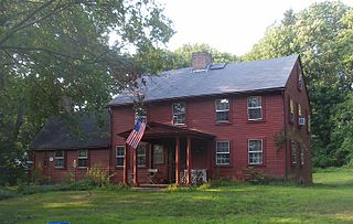
The Thomas Fenner House or the "Sam Joy Place" is a historic stone-ender house in Cranston, Rhode Island. It the oldest surviving house in the Providence Plantations portion of Rhode Island. The only older structure in the state is the White Horse Tavern in Newport. The house was built as a farmhouse in 1677 after King Philip's War by Captain Arthur Fenner for his son Major Thomas Fenner (1652-1718). The house was added to the National Register of Historic Places in 1990. The House is available for short stays by those interested in the historical and architectural significance of the property. It also is made available to educational groups to visit and study.

The Norwood Avenue Historic District is a residential historic district in Cranston and Providence, Rhode Island. It includes all the properties along Norwood Avenue between Broad Street in Cranston and Green Boulevard in Providence. It is lined with houses built mostly between 1890 and 1930 in the Queen Anne and Colonial Revival styles.
The Sheldon House is a historic house located in Cranston, Rhode Island. The house was listed on the National Register of Historic Places on January 5, 1989.

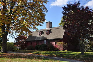
The Nathan Westcott House is a historic house in Cranston, Rhode Island. This 1+1⁄2-story gambrel-roofed wood-frame house was built c. 1770 as a "half house", and extended about 20 years later, based on architectural evidence. The house was probably built by Nathan Westcott, a member of the locally prominent Westcott family, whose progenitor was among the area's early settlers. The house was later owned by the Joy family, whose homestead stands next door.

The Governor William Sprague Mansion is an historic mansion and museum at 1351 Cranston Street in Cranston, Rhode Island. The house was the birthplace of Governor William Sprague III and his nephew, Governor William Sprague IV.
The Bridgham–Arch–Wilson Streets Historic District is a predominantly residential historic district in Providence, Rhode Island. It is located southwest of downtown Providence, and was developed beginning in the 1840s as a suburban part of the city. It is roughly in the shape of a boot, roughly bounded by Cranston, Bridgham, Elmwood, and Harrison Streets. Most of the housing is architecturally reflective of the mid-19th century, with the Greek Revival, Italianate, and Second Empire styles well represented. Development in the area slowed in the late 19th and early 20th centuries, so there are only a modest number of Queen Anne, Stick style, and Colonial Revival properties. Most of the houses are either 1-1/2 or 2+1⁄2-story wood-frame structures, and are generally set on fairly small lots. There are 175 primary buildings in the district, of which more than 150 are historically significant.
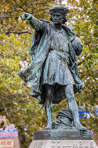
Columbus is a historic statue in Johnston, Rhode Island. The statue is a bronze cast of a sterling silver statue which was created by Rhode Island's Gorham Manufacturing Company for the 1892 World's Columbian Exposition in Chicago. The original silver statue was not meant for permanent exhibition, but rather as a demonstration of the skills of the Gorham Company, and was later melted down. The bronze cast was dedicated on November 8, 1893, in Columbus Square, in Providence, Rhode Island, United States as a gift from the Elmwood Association to the City of Providence.

The Davol Rubber Company is a historic industrial site at Davol Square, at Point and Eddy Streets in Providence, Rhode Island.

Louttit Laundry was at one time the largest laundry business in Rhode Island, with 150 employees and 16 outlets throughout the state. Their historic building at 93 Cranston Street was on the National Register of Historic Places. The company was sold in 1985 and closed in 1987. The Cranston Street building was built in 1906, expanded in 1925, damaged by fire in 2001, and demolished in 2008.

The Joseph and William Russell House is a historic house at 118 North Main Street in the College Hill area of Providence, Rhode Island, United States. It is a brick Georgian house built in 1772. Its original interior woodwork has been removed and distributed among museums around the United States.

The Broadway–Armory Historic District is a historic district encompassing a mainly residential mixed-used urban area west of downtown Providence, Rhode Island.
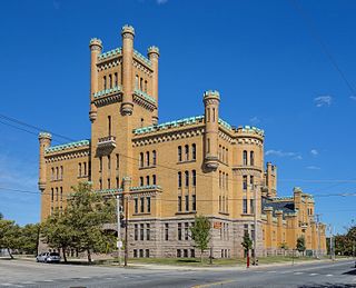
The Cranston Street Armory is an historic building in the Broadway–Armory Historic District of Providence, Rhode Island. It was built in 1907 at a cost of $650,000.00. The building was occupied by the Rhode Island National Guard from its opening until 1996. Since then, parts of the building have been used as film studios, and some of its offices occupied by the Rhode Island State Fire Marshal. The National Trust for Historic Preservation listed the Armory as one of "America's 11 Most Endangered Historic Places" in its annual list for 1997. Its distinctive yellow bricks, crenellated turrets, and decorative stonework mark it as a historically significant building and neighborhood icon.

Rosedale Apartments are a historic apartment house at 1180 Narragansett Boulevard in Cranston, Rhode Island. This U-shaped apartment block stands overlooking Narragansett Bay, with three stories facing the street and four toward the bay. The Art Moderne structure was designed by Herbert R. Hunt and built in 1939–40. It is a rare statewide example of a large-scale building in this style, and was one of only a few built in Cranston before the Second World War.

William R. Walker & Son was an American architectural firm based in Providence, Rhode Island. From 1881 to 1936 it was led by three successive generations of the Walker family: founder William R. Walker, his son W. Howard Walker and his grandson William R. Walker II.

Edwin E. Cull was an American architect in practice in Providence, Rhode Island from 1921 until his death. In 1946 he was cofounder of what is now The Robinson Green Beretta Corporation, one of the largest architecture firms in Rhode Island.
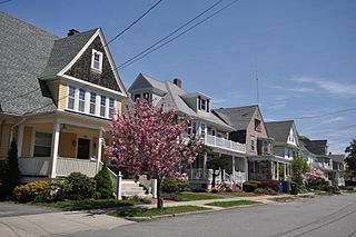
The Edgewood Historic District–Sally Greene Homestead Plats is a residential historic district in the Edgewood neighborhood of eastern Cranston, Rhode Island. Bounded by Glen Avenue to the north, Broad Street to the west, Massasoit Street to the south, and the Providence River to the east, this area was developed between 1900 and 1963 as a streetcar suburb for middle and lower middle class residents on what was once a country estate. The district was listed on the National Register of Historic Places in 2016.


