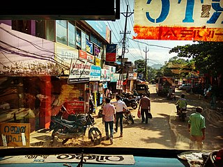
Vithura Town, also known as the Hill Town of Trivandrum, is located 36 km from Thiruvananthapuram capital of the Kerala state in India. Vithura is the culmination of the crossroads to many tourist, cultural, and religious centres. Surrounded by the Western Ghats (Sahyadris), Vithura is a prime tourist spot. The village is rich with a very scenic beauty and a good climate year-round. The Indian Institute of Science Education and Research, Thiruvananthapuram campus, one of the leading public science universities in the country, is situated here.
Piravom is a Municipality in Ernakulam district and a suburb of Kochi in the Indian state of Kerala. It is located with in 31 km southeast of Kochi city center, at the boundary of the Ernakulam and Kottayam districts. Piravom is famous for its Hindu temples and Christian churches. Piravom has a river-front, verdant hills, and paddy fields.

Thalavoor is a village located in the district of Kollam in the Kerala state of India. It is 77 km to the north of the State Capital, Thiruvananthapuram, and 28 km to the east of District Capital, Kollam. Thalavoor village is bordered by Pattazhy village to the north, Pidavoor village to the north-east, Vilakkudy village to the south-east, Melila village to the south and Mylom village to the west. Thalavoor is a part of Pathanapuram Block Panchayat
Pothencode, is a rapidly developing town and a developing area of Thiruvananthapuram District in the Indian state of Kerala. Spiritual leaders Brahmasree Jagadguru Swami Sathyananda Saraswathi, Sree Rama Dasa Mission, Karunakara Guru and founder of Punnyabhumi Daily hail from the village. Pothencode is 18 km (11 mi) from East Fort.
Perumannoor is a village situated in the Punalur taluk in the district of Kollam in India. This village is situated 65 km north of the capital city of Thiruvananthapuram in the state of Kerala. It is famous for its festivals, Churches and temples, such as Perumannoor Devi temple, Shri Krishna temple and Pullamcode Marthoma Church.The Perumannoor Government LPS, Public Library & Sub PHC are the main land marks. The famous Malamel Shiva temple and Arackal devi temple are also near this village.
Kaithaparampu (Kaithaparambu) is a village and part of Ezhamkulam Panchayath in the Pathanamthitta district of Kerala. It is part of the Adoor constituency of Kerala State and Indian Parliament.
Mulakuzha is a village in Alappuzha district in the state of Kerala, India. Mulakuzha is located in Chengannur tehsil, and residents are mostly artisans and farmers.
Pallippad is a village near Haripad in Alappuzha district in the Indian state of Kerala. The name Pallippad is believed to be derived from Buddhist terminology.The famous River Achankovil Aar passes by Pallippad before it reaches Veeyapuram. The village has abundant water resources, small lakes, and water paths that connect to Alappuzha.

Thycattusserry is a village in the Cherthala taluk of the Alappuzha district in the Indian state of Kerala.
Kottappady is a village in Kothamangalam Taluk in Ernakulam district of Kerala State, India. It belongs to Central Kerala Division. It is located 10 km from Kothamangalam. The village came into existence in the year 1953.

Pavithreswaram is a village in Kottarakkara taluk of Kollam district in the state of Kerala, India.
Poothakkulam, also known as Bhoothakulam, is a village in Kollam district in the state of Kerala, India. The village is located 3.9 km away from Paravur, 11.4 km from Varkala and 23 km from Kollam. In 2011, it had a population of 628,451 residents. The village covers an area of 16.56 km2.
Melukavu (Melukavumattom) is a village in the eastern part of Meenachil Taluk in Kottayam District of Kerala state, India.
Enadimangalam is a village in the Pathanamthitta district of the state of Kerala, India. Enadimagalam includes mainly Elamanoor, Maroor etc.Enadimagalam is often recognised as a Panchayat. Enadimangalam had a population of around 30000.
Peringara is a " panchayat" village in Thiruvalla Taluk of Pathanamthitta district in the state of Kerala, in India. It lies at a distance of around 4 kilometres from Thiruvalla.
Perumpetty is a village under Mallappally Taluk in Pathanamthitta district, in the state of Kerala, India.
Vellarada is a border village situated in Thiruvananthapuram district in the state of Kerala, India. It is 42 km from Thiruvananthapuram. It is the southernmost part of Kerala state, sharing its border with Tamil Nadu. Vellarada is said to be the threshold to the high-range areas of the eastern part of Thiruvananthapuram district. The southernmost point of Western Ghats in Kerala is near Vellarada.
Babaleshwar is a taluka place in the southern state of Karnataka, India. It is located in the Bijapur Taluka of Bijapur district in Karnataka. It is 22 km from the district headquarters, the city of Bijapur.

Thuravoor is a Gram Panchayat in Aluva Taluk of Ernakulam District in the South Indian state of Kerala. Thuravoor Grama Panchayath is nearly 5 km from Angamaly Town. The Panchayat covers 12.13 km2 in area. The borders of this panchayat are Mookkannoor and Manjapra Panchayat in the north, Manjapra, Malayattoor-Neeleeswaram Panchayat in the East. Kalady panchayat and Angamaly Municipality in the south, and Karukutty and Mookkannoor Panchayat on the west.
Ayavana is a panchayath in Eranakulam district in the Indian state of Kerala. It is situated 8 km away from Muvattupuzha on the banks of river Kaliyar. Ayavana panchayath includes Anchelpetty, Kakkattoor, Kalampoor, Enanalloor, Kavakkad, Karimattom etc.


