
Arundel is a town in York County, Maine, United States. At the 2020 census, the population was 4,264. It is part of the Portland–South Portland–Biddeford, Maine Metropolitan Statistical Area. The Municipality of Arundel includes the constituent communities and neighbourhoods of: Arundel Village, Vinegar Hill, Riverside Arundel, Log Cabin Crossing, Goff Mill, Millers Crossing, and Cottagehill, among other neighbourhoods in an inland area adjacent to the Towns of Kennebunkport and Biddeford. In 2014, Arundel was named “Best Place to Live in Maine” by Downeast Magazine.
Perkins Township is an unorganized territory in Sagadahoc County, Maine, United States. Originally incorporated as the town of Perkins, it was later abandoned, and has been uninhabited since the 1940s. The township comprises Swan Island, Little Swan Island and some tidal flats—all within the Kennebec River between the towns of Richmond and Dresden. The Swan Island Historic District comprises most of the township, with eight buildings, five structures and 1,500 acres (610 ha). Some of the buildings date to the 1750s. The district was added to the National Register of Historic Places in 1995. The entire township is now protected as the Steve Powell Wildlife Management Area, and is under the jurisdiction of the Maine Department of Inland Fisheries and Wildlife. Camping, hunting, fishing, and wildlife viewing are permitted between May and October; reservations are required.

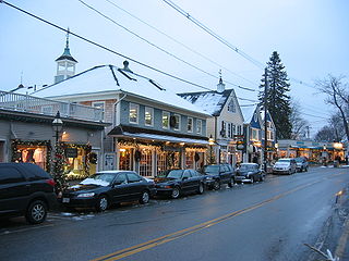
Kennebunk is a town in York County, Maine, United States. The population was 11,536 at the 2020 census. Kennebunk is home to several beaches, the Rachel Carson National Wildlife Refuge, the 1799 Kennebunk Inn, many historic shipbuilders' homes, the Brick Store Museum and the Nature Conservancy Kennebunk Plains, with 1,500 acres (6 km2) of nature trails and blueberry fields.
Kennebunkport is a resort town in York County, Maine, United States. The population was 3,629 people at the 2020 census. It is part of the Portland–South Portland–Biddeford metropolitan statistical area.
Regional School Unit 71, formerly Maine School Administrative District 71 is a school district containing the towns of Kennebunk, Maine and Kennebunkport, Maine. It currently provides 5 schools for the children within its boundaries:

Goat Island Light is a lighthouse located off Cape Porpoise near Kennebunkport in southern Maine. Goat Island Light was established in 1835 to guard the entrance to Cape Porpoise Harbor. The original station was upgraded in 1859 to the current brick tower with a fifth order Fresnel lens. Keeper's quarters were added to the island in 1860. The light station was automated by the United States Coast Guard in 1990 and is currently active. The keepers dwellings and tower are leased to the Kennebunkport Conservation Trust. Goat Island Light can be seen from shore in Cape Porpoise Harbor just off State Route 9 north of Kennebunkport or is viewable by boat. The island is currently closed to the public except by special arrangement.

The York Historic District encompasses the historic village center of York, Maine, one of the oldest communities in the state. The expansive 1,700-acre (690 ha) district includes the oldest church in Maine, built by its oldest congregation in 1747, and the Old York Gaol, a National Historic Landmark that is one of the oldest public buildings in the United States. The district was listed on the National Register of Historic Places in 1973.

The Perkins Tide Mill was one of the last surviving 18th-century tide mills in the United States. Located on Mill Lane in Kennebunkport, Maine, it was built in 1749 and operated until 1939. It was destroyed by an arsonist in 1994. Listed on the National Register of Historic Places in 1973, the property's present owners, the Kennebunkport Conservation Trust, are contemplating construction of a replica.

The Main Street Historic District encompasses the historic commercial center of Damariscotta, Maine. Although the community was settled in the 18th century, most of its downtown area dates to the second half of the 19th century due to an 1845 fire. Lining Main Street east of the Damariscotta River, the downtown has a well-preserved collection of commercial, residential, and civic structures from the period. The district was added to the National Register of Historic Places in 1979, and enlarged in 2001.
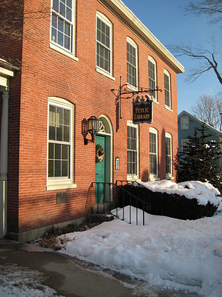
The Louis T. Graves Memorial Public Library is the public library of Kennebunkport, Maine. It is located at 18 Maine Street, in a handsome brick Federal style building that served as the U.S. Customhouse from 1815 until 1913. The building was listed on the National Register of Historic Places on January 18, 1974.

The Kennebunk River Club is a private recreational and social club at 116 Ocean Avenue in Kennebunkport, Maine. Established in 1888 by summer residents of the resort area, its main building, constructed the following year, is a high-quality example of Shingle style architecture, and was listed on the National Register of Historic Places in 1975.

The Alfred Historic District is an historic district encompassing the historic village center of Alfred, Maine. The roughly Y-shaped district radiates from the junction of Oak Street with Kennebunk, Waterboro, and Saco Roads, and is characterized by high-quality 19th-century wood-frame buildings. The district was added to the National Register of Historic Places in 1983.

The Cape Arundel Golf Club, originally just the Arundel Golf Club, is a country club at 19 River Road in Kennebunkport, Maine. Established in 1896, it is one of the oldest golf clubs in the state. Its 18-hole course was laid out in two stages, with its original nine holes designed by Alexander H. Findley in 1900, and later redesigned and expanded by Walter Travis. The club has long been a social scene for the summer elite of the Kennebunkport area, notably including former United States President George H. W. Bush. The club was listed on the National Register of Historic Places in 2009.
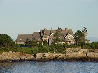
The Cape Arundel Summer Colony Historic District encompasses an enclave of large summer estates on the coast of Kennebunkport, Maine. The area was developed in the late 19th and early 20th century as a resort area for the wealthy of the northeastern United States. It notably includes the Kennebunk River Club and Walkers Point, the location of the Bush compound, which has a Shingle-style house built in 1903. The district was listed on the National Register of Historic Places in 1984.

The Kennebunk Historic District encompasses a large portion of the historic town center of Kennebunk, Maine. Established in 1736, the district includes a significant number of fairly high-style houses from the late 18th and early 19th centuries, when Kennebunk was at its height as a shipbuilding and maritime shipping center. The district was listed on the National Register of Historic Places in 1974.
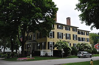
The Captain Nathaniel Lord Mansion is a historic house at 6 Pleasant Street in the village center of Kennebunkport, Maine. Built in 1812 by a wealthy shipowner, it is a fine example of Federal period architecture, which remained in the same family until 1972. It is now a bed and breakfast called The Captain Lord Mansion, Inn & Spa. It was listed on the National Register of Historic Places in 1973.

The Lower Alewive Historic District encompasses a rural agricultural landscape in northwestern Kennebunk, Maine. It includes four farm properties, all originally laid out in the 1750s, between the Kennebunk River to the north, and a street now variously named Russell Farm Road, Emmons Road Extension, and Winnow Hill Lane to the south. The district was listed on the National Register of Historic Places in 1994.
The Federal Street Historic District of Brunswick, Maine encompasses a part of the town whose development was influenced by its 18th-century success as a shipping center, and by the presence of Bowdoin College, whose historic central campus is part of the district. In addition to the campus, the district includes a series of relatively high-style Federal and later-period houses along Federal Street and Maine Street, which join the campus to downtown Brunswick. The district was listed on the National Register of Historic Places in 1976.

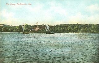
The Richmond Historic District encompasses the historic village center of Richmond, Maine. Established in the 17th century, the town reached its height of prosperity in the 19th century as a major shipbuilding center on the Kennebec River. The district was listed on the National Register of Historic Places in 1973.

The Wiscasset Historic District is a 101-acre (41 ha) historic district that encompasses substantially all of the central village of Wiscasset, Maine. The district includes at least 22 contributing buildings and two other contributing sites, one being a cemetery whose oldest stone is from 1739. Located on the west bank of the Sheepscot River and settled in the 18th century, Wiscasset was a prominent harbor in Mid Coast Maine, and a major shipbuilding and merchant port, until the War of 1812 ended its prosperity. The village center includes fine examples of Federal period architecture, most built between about 1780 and 1820, including one National Historic Landmark, the Nickels-Sortwell House. The district was listed on the National Register of Historic Places in 1973.


