
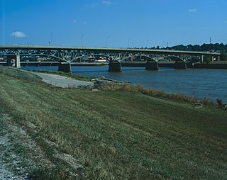
The Fort Madison Toll Bridge is a tolled, double-decked swinging truss bridge over the Mississippi River that connects Fort Madison, Iowa, and unincorporated Niota, Illinois. A double-track railway occupies the lower deck of the bridge, while two lanes of road traffic are carried on the upper deck. The bridge is about 1 mile (1.6 km) long with a swing span of 525 feet (160 m), and was the longest and largest double-deck swing-span bridge in the world when constructed in 1927. It replaced an inadequate combination roadway/single-track bridge completed in 1887. The main river crossing consists of four 270-foot (82 m) Baltimore through truss spans and a swing span made of two equal arms, 266 feet (81 m) long. In 1999, it was listed in the National Register of Historic Places under the title, Fort Madison Bridge, ID number 99001035. It was also documented as survey number IA-62 by the Historic American Engineering Record, archived at the Library of Congress. Construction and photographic details were recorded at the time in Scientific American magazine.

The Clinton Railroad Bridge, also called the Chicago and Northwestern Railway Bridge or more simply the Clinton Bridge, is a bridge that carries double tracked rail lines across the Mississippi River between Clinton, Iowa, and Fulton (Albany), Illinois. The bridge is a truss bridge with a swing span crossing the main river channel and is adjacent to the Gateway Bridge. The original bridge was constructed in 1858, and the first train crossed the bridge on January 19, 1860. The bridge was the second railroad crossing over the Mississippi River. In 1870, the bridge was declared a post route, therefore stopping the occupation of steamboats and approval of railroads. From 1859 to 1908, the mileage in operation increased from 28,789 to 229,230, prompting the Chicago and North Western Railway to replace the bridge with a new structure in 1900.

The Western Bridge and Construction Company, located in Omaha, Nebraska, was one of the foremost bridge engineering and manufacturing companies in the Midwestern United States. Several of their bridges are now listed on the National Register of Historic Places. Their headquarters were located in the Bee Building in Downtown Omaha.

The Burlington, Cedar Rapids and Northern Railway (BCR&N) was a railroad that operated in the United States from 1876 to 1903. It was formed to take over the operations of the bankrupt Burlington, Cedar Rapids and Minnesota Railway, which was, in turn, the result of merging several predecessor lines, the construction of which began in 1869. The corporate headquarters were in Cedar Rapids, Iowa, and it had operations in Iowa and in Minnesota. It was succeeded by the Chicago, Rock Island and Pacific Railway.

The Illinois Central Missouri River Bridge, also known as the IC Bridge or the East Omaha Bridge, is a rail through truss double swing bridge across the Missouri River connecting Council Bluffs, Iowa, with Omaha, Nebraska. It is owned by the Canadian National Railway and is closed to all traffic. At 521 feet long, the second version of the bridge was the longest swing bridge in the world from when it was completed in 1903 through 1915. In 1975 it was regarded as the third longest swing bridge.
The Jefferson Street Viaduct is a historic structure located in Ottumwa, Iowa, United States. The riveted Warren deck truss bridge was completed in 1936. It was listed on the National Register of Historic Places in 1998 as a part of the Highway Bridges of Iowa MPS.
The River Street Bridge at Marble Rock, Iowa, also known as Richard W. "Dick" Weldon River Street Bridge, has the appearance of a being a filled spandrel deck arch bridge, but it is not. When it was built in 1912, concrete girders were relatively new, and this was built with straight ones in three 30-foot (9.1 m) sections, by the Miller-Hey Construction Company of Des Moines, in one of its first contracts. The straight girders carried the load, and it is a girder bridge. However this was given a touch of elegance by its arched spandrels, which usually appear above load-bearing arches in deck arch bridges.
The Alden Bridge is a historic bridge in Alden, Iowa, which carries the town's Main Street over the Iowa River, United States. The concrete bridge is 150 feet (46 m) long and consists of two spans. It was built in 1936 to replace an earlier wooden bridge that had begun to deteriorate. The Weldon Brothers Construction Company supervised the bridge's construction, while the Iowa State Highway Commission designed the structure; it was one of the first bridges designed by the ISHC, which used similar plans for many other bridges in the state. Labor for the construction effort came from the Works Progress Administration, providing jobs for many of Hardin County's unemployed residents. The bridge was dedicated on July 4, 1936, as part of Alden's Independence Day celebrations.
The Boone Bridge was located southwest of Boone, Iowa, United States. It spanned the Des Moines River for 647 feet (197 m). The area in which this bridge was built was a pivotal transportation corridor in the early 20th century. The Chicago and North Western Railroad built the Boone Viaduct upstream from this location in 1901. It was the world's longest two-track viaduct. The county built a pin-connected truss bridge to carry a county road over the river just downstream from this location in 1909. In 1913 it was chosen as part of the route of the Lincoln Highway, the nation's first transcontinental highway. Because of its narrow width of only 16 feet (4.9 m) and an increase in traffic, a new bridge was required. The Iowa State Highway Commission designed this bridge in 1927. It was composed of two riveted Pratt and two Parker through trusses. The contract to build the structure was awarded in November 1927 to the A. Olson Construction Company of Waterloo, Iowa for $77,900. It was completed later in 1928. The bridge carried U.S. Route 30 traffic until it was rerouted to the south. It carried a county road until it was replaced in the early 21st century, and dismantled. The bridge was listed on the National Register of Historic Places in 1998.
The Kittyhawk Avenue Bridge is located southwest of Carroll, Iowa, United States. The 52-foot (16 m) span carries traffic on Kittyhawk Avenue over an unnamed stream. This bridge was one of 15 similar spans that Carroll County had built in 1913. The county board of supervisors contracted with the Standard Bridge Company of Omaha to build the Warren pony truss structures that were designed by the Iowa State Highway Commission (ISHC). They were supported by a timber substructure. The bridges became the prototype of what would become the ISHC's standard design. Standard Bridge was paid $29,174 to build all the bridges. This bridge was listed on the National Register of Historic Places in 1998.
The Olympic Avenue Bridge is located northeast of Carroll, Iowa, United States. The 46-foot (14 m) span carries traffic on Olympic Avenue over an unnamed stream. This bridge was one of 15 similar spans that Carroll County had built in 1913. The county board of supervisors contracted with the Standard Bridge Company of Omaha to build the Warren pony truss structures that were designed by the Iowa State Highway Commission (ISHC). They were supported by a timber substructure. These bridges became the prototype of what would become the ISHC's standard design. Standard Bridge was paid $29,174 to build all the bridges. The estimated cost of this bridge was $1,208. It was listed on the National Register of Historic Places in 1998.
The Quail Avenue Bridge is located southeast of Carroll, Iowa, United States. The 37-foot (11 m) span carries traffic on Quail Avenue over an unnamed stream. This bridge was one of 15 similar spans that Carroll County had built in 1913. The county board of supervisors contracted with the Standard Bridge Company of Omaha to build the Warren pony truss structures that were designed by the Iowa State Highway Commission (ISHC). They were supported by a timber substructure. The bridges became the prototype of what would become the ISHC's standard design. Standard Bridge was paid $29,174 to build all the bridges, which included the costs for this bridge at $1,247. It was listed on the National Register of Historic Places in 1998.
The Robin Avenue Bridge is located east of Carroll, Iowa, United States. The 46-foot (14 m) span carries traffic on Robin Avenue over an unnamed stream. This bridge was one of 15 similar spans that Carroll County had built in 1913. The county board of supervisors contracted with the Standard Bridge Company of Omaha to build the Warren pony truss structures that were designed by the Iowa State Highway Commission (ISHC). They were supported by a timber substructure. The bridges became the prototype of what would become the ISHC's standard design. Standard Bridge was paid $29,174 to build all the bridges, which included the costs for this bridge at $1,208. It was listed on the National Register of Historic Places in 1998.
The Storm Creek Bridge is located northeast of Carroll, Iowa, United States. The 64-foot (20 m) span carries traffic on Phoenix Avenue over Storm Creek. This bridge was one of 15 similar spans that Carroll County had built in 1913. The county board of supervisors contracted with the Standard Bridge Company of Omaha to build the Warren pony truss structures that were designed by the Iowa State Highway Commission (ISHC). They were supported by a timber substructure. The bridges became the prototype of what would become the ISHC's standard design. Standard Bridge was paid $29,174 to build all the bridges, which included the costs for this bridge at $2,026. It was listed on the National Register of Historic Places in 1998.
The Storm Creek Bridge 2 is located east of Carroll, Iowa, United States. The 57-foot (17 m) span carries traffic on 190th Street over Storm Creek. This bridge was one of 15 similar spans that Carroll County had built in 1913. The county board of supervisors contracted with the Standard Bridge Company of Omaha to build the Warren pony truss structures that were designed by the Iowa State Highway Commission (ISHC). They were supported by a timber substructure. The bridges became the prototype of what would become the ISHC's standard design. Standard Bridge was paid $29,174 to build all the bridges, which included the costs for this bridge at $1,987. It was listed on the National Register of Historic Places in 1998.
The Rockwell City Bridge is located just east of Rockwell City, Iowa, United States. The 60-foot (18 m) span carried traffic on 270th Street over an unnamed stream. In 1915 Calhoun County requested the Iowa State Highway Commission (ISHC) and Des Moines engineer James B. Marsh to design a bridge for this crossing. The ISHC designed a double span concrete girder structure, while Marsh submitted his patented single-span rainbow arch configuration. They chose the Marsh submission, and contracted with the Iowa Bridge Company to build six bridges for $11,690, which included the costs for this bridge at $4,107.65. Originally built to serve a county road, it was later incorporated into the route for U.S. Highway 20 and carried heavy traffic until the highway was realigned in 1981. While no longer in use, the bridge remains in place just south of the replacement span. It was listed on the National Register of Historic Places in 1998.

The Kilbourn Bridge is located south of Kilbourn, Iowa, United States. It carried traffic on Lark Avenue over the Des Moines River for 855 feet (261 m). In 1890, the Van Buren County Board of Supervisors contracted with the Western Bridge Company of Chicago to build a bridge at the Kilbourn ferry crossing. It was destroyed in a flood in 1903, and the Board of Supervisors put off replacing the bridge until 1907, then all the proposals came over the $20,000 limit. They removed the limit the following year. The six-span bridge was designed by the Iowa State Highway Commission (ISHC), and built by the Ottumwa Supply and Construction Company of Ottumwa, Iowa. It was the first large-scale engineering project undertaken by the newly formed ISHC. The Kilbourn Bridge was listed on the National Register of Historic Places in 1998.
The Shellsburg Bridge is a historic structure located in Shellsburg, Iowa, United States. It spans Bear Creek for 64 feet (20 m). In April 1915 the Benton County Board of Supervisors contracted with Alfred Vinall to build the new bridge near Shellsburg's downtown area. He used a special design by the Iowa State Highway Commission (ISHC), and completed the project in late 1915 for $6,081.06. The ISHC designed plain bridges for its rural spans, but because this span is in town it features decorative elements: bichrome concrete detailing, molded concrete balustrades, and incised spandrel panels. The bridge was listed on the National Register of Historic Places in 1998.

The Ocean-to-Ocean Bridge is a through truss bridge spanning the Colorado River in Yuma, Arizona. Built in 1915, it was the first highway crossing of the lower Colorado and is the earliest example of a through truss bridge in Arizona. It is also the only example of a Pennsylvania truss within Arizona. Originally the bridge carried the transcontinental Ocean-to-Ocean Highway and later carried its successor, US 80 until a new bridge was built to the west in 1956. Between 1988 and 2001, the bridge was closed to vehicular traffic and only traversable by pedestrians and bicyclists. After a major restoration, the bridge was rehabilitated and reopened to vehicular traffic in 2002, with a re-dedication by the Quechan nation and Yuma Crossing National Heritage Area. The bridge became part of Historic US 80 in 2018.

The Chain Lakes Bridge is a historic structure located southeast of Palo, Iowa, United States. It carries a pedestrian trail for 370 feet (110 m) over the Cedar River. The Linn County Board of Supervisors began planning for this span in the early 1880s. They appropriated $20,000 for this two-span Pratt through truss The Wrought Iron Bridge Company of Canton, Ohio, which built bridges in the county since 1879, completed this structure in 1884. The bridge was listed on the National Register of Historic Places in 1998. While it was built to carry vehicular traffic, it is now in a nature preserve maintained by the Linn County Conservation Board.


