Kanjirappally is a taluk and a town in Kottayam district situated about 38 km (24 mi) away from the district capital, in the state of Kerala, in southwestern India.
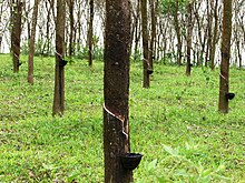
Mundakayam, is a town in Kanjirappally Taluk in the Kottayam District of Kerala. It is the doorway to the high ranges of southern Kerala, and is at the border of Kottayam and Idukki districts. The next nearest town, Kanjirappally, is 14 km (8.7 mi) & Erumely is 12 km from Mundakayam. Mundakayam has rubber plantations, and greenery. The Manimala River runs through Mundakayam. It is located 48 km east of the district headquarters at Kottayam and 148 km from the state capital, Thiruvananthapuram. The name Mundakayam is said to be derived from the Mundi cranes that used to be seen along the Manimala River banks.
Kozhencherry is a census town in Pathanamthitta district of Central Travancore region in Kerala state, India. As of 2011 census, the population was 12,021 of which 5,594 are males while 6,427 are females.

Uzhavoor is an expanding town in Kottayam district, Kerala in India. It is just 32 km away from the administrative capital Kottayam District. Most of its residents are either wealthy farmers or businessmen. Many of the houses belong to NRIs. The tenth President of India, K. R. Narayanan, was born and brought up in this village. The newly expanded road which connects the city of Pala and other destinations such as Sabarimala to the city of Muvattupuzha passes through Uzhavoor. The town is 177 km from the state capital Thiruvananthapuram.

Ponkunnam is a census town in Kerala, India, part of Kottayam district under Kanjirappally taluk. Ponkunnam literally means golden mountain (ponn = gold, kunn = mountain). Nearby towns are Kanjirappalli, Manimala and Pala. This part of Kerala is famous for its fertile land and rubber plantations. It is at an altitude of 495 ft (151 m) above mean sea level. The town is at the junction of two major roads in Kerala: NH 183 and Main Eastern Highway. The climate is moderate with timely cold breezes and the town is the gateway to the Western Ghats. The town is famous for its volleyball traditions and customs. Almost every year there is an ever-rolling volleyball tournament happening in Ponkunnam Mahatma Gandhi Mini Stadium.

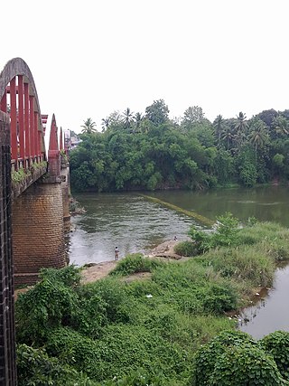
Ranni or Ranny is a town in the Pathanamthitta district of Kerala, India, and the 16th largest taluk in Kerala, located on both sides of the Pamba River. It Is located 27 km from Chengannur railway station & NH 183 in Chengannur.

Pathanamthitta, is a municipality situated in the Southern Kerala, India, spread over an area of 23.50 km2. It is the administrative capital of Pathanamthitta district. The town has a population of 37,538. The Hindu pilgrim centre Sabarimala is situated in the Pathanamthitta district; as the main transport hub to Sabarimala, the town is known as the 'Pilgrim Capital of Kerala'. Pathanamthitta District, the thirteenth revenue district of the State of Kerala, was formed with effect from 1 November 1982, with headquarters at Pathanamthitta. Forest covers more than half of the total area of the District. Pathanamthitta District ranks the 7th in area in the State. The district has its borders with Allepey, Kottayam, Kollam and Idukki districts of Kerala and Tamil Nadu. Nearest city Is Thiruvalla, located at a distance of 30 km. Thiruvalla railway station Is 30 km via Thiruvalla-Kumbazha highway. Buses ply every 5 Minutes from Thiruvalla To Pathanamthitta & vice versa.
Vayalathala is a small village situated in the Pathanamthitta district of Kerala State in India.
Manimala is a small town and a village in Kottayam district in the Indian state of Kerala, situated about 12 kilometres (7.5 mi) from the nearest town Kanjirappally. It's declared as a folklore village since 2011 by the central government to promote folklore.

Koodal is the second largest town in Konni Taluk at Pathanamthitta District, located in Kerala state, India.Koodal Situates On Main Eastern Highway.
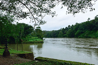
Perunad (Ranni-Perunad) is a scenic hilly village in Pathanamthitta district, Kerala state, India.Nearest Railway Station Is Thiruvalla Located At A Distance Of 62 km. It's located on the banks of Pamba River and Kakkadu River.
Vettikkavala is a village located in the Kollam district in the state of Kerala, India. One point of interest within the village is a Shiva-Vishnu temple which hosts a special deity called Vathukkal Njali Kunju. An annual celebration of Pongala is held at the temple. The village is also well known for temple arts and a palace constructed by Sree Moolam Thirunal.

Ezhumattoor is a village in Pathanamthitta district in the state of Kerala, India.It Is Part Of Thiruvalla Constituency.It has 27.89 km2 area,it is divided into 14 wards for administrative purpose,it was formed by a government Order on 16 January 1952.

Thamarassery, formerly known as Thazhmalachery, is one of the taluks and a major hill town in the Kozhikode district of Kerala, India, 30 km north-east of Kozhikode (Calicut) city and 29 km east of Koyilandy. The town lies on National highway 766.

Chengara is a small village situated in the Pathanamthitta district in Kerala, India. It is known for its natural environment, hills and climate, and was found to have the cleanest air, in terms of concentration of dust particles. Chengara is surrounded on three sides by Harrisons Malayalam Limited, a rubber plantation company.
Keezhvaipur is a village in the Mallappally Taluk which is one of five Taluks that makes up the Pathanamthitta district, in Kerala State, India.It Is Part Of Thiruvalla Constituency.Keezhuvaipur lies in the bank of river Manimala and is famous for its traditions, cultures, and customs. The town is located on the Kottayam-Punalur State Highway. Keezhuvaipur is 3 km away from Mallappally, 11 km from Kozhencherry and 13 km from Tiruvalla.

Angamoozhy is a village in Pathanamthitta district in the Indian state of Kerala. Angamoozhy is located near the Kakkad power station and the Sabarimala temple. Geographically Angamoozhy is High-range area.
Mundathanam is a place in Kangazha Village, Changanassery Taluk and Kottayam District of Kerala State in India. It is located in eastern part of Kottayam district and adjacent to Pathanamthitta district. It is well connected to Changanacherry. Mundathanam is famous for almost all Christian denominations and their churches.

Nilakkal, also spelled Nilackal, is an important base camp of Sabarimala pilgrims located in Ranni tehsil of Pathanamthitta district in the Indian state of Kerala. Sabarimala temple is located at a distance of 23 km (14 mi) from Nilakkal.
Thulappally is a small village in Perunad panchayath of Ranni tehsil in Pathanamthitta district of Kerala state, India.