Taos is a town in Taos County in the north-central region of New Mexico in the Sangre de Cristo Mountains. Initially founded in 1615, it was intermittently occupied until its formal establishment in 1795 by Nuevo México Governor Fernando Chacón to act as fortified plaza and trading outpost for the neighboring Native American Taos Pueblo and Hispano communities, including Ranchos de Taos, Cañon, Taos Canyon, Ranchitos, El Prado, and Arroyo Seco. The town was incorporated in 1934. As of the 2010 census, its population was 5,716.

Picuris Pueblo is a historic pueblo in Taos County, New Mexico, United States. It is also a census-designated place (CDP) and a federally recognized tribe of Native American Pueblo people. The 2010 census estimated that 68 people lived in the CDP, while 267 people in the U.S. reported being of the tribal group Picuris alone and 439 reported being of the tribal group Picuris alone or in combination with other groups. Picurís Pueblo is a member of the Eight Northern Pueblos. Their own name for their pueblo is P'įwweltha, meaning "mountain warrior place" or "mountain pass place." They speak the Picuris dialect of the Northern Tiwa language, part of the Kiowa-Tanoan language family.

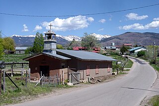
Ranchos de Taos is a census-designated place (CDP) in Taos County, New Mexico. The population was 2,390 at the time of the 2000 census.

Las Trampas or just Trampas, is a small unincorporated town in Taos County, New Mexico. Founded in 1751, its center retains the original early Spanish colonial defensive layout from that time, as well as the 18th-century San José de Gracia Church, one of the finest surviving examples of Spanish Colonial church architecture in the United States. The village center was designated a National Historic Landmark District in 1967.

Martinez Hacienda, also known as Hacienda de los Martinez, is a Taos County, New Mexico hacienda built during the Spanish colonial era. It is now a living museum listed on the National Register of Historic Places. It is located on the bank of the Rio Pueblo de Taos.
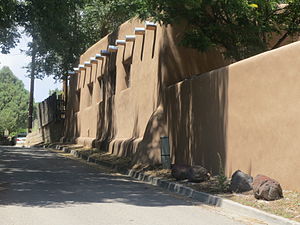
Taos Plaza is a center of shops and monuments within the Taos Downtown Historic District in Taos, New Mexico.
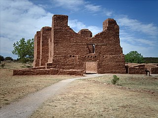
Quarai, also known historically as Quarai State Monument, is a prehistoric and historic unit of the Salinas Pueblo Missions National Monument located north of Mountainair, New Mexico. A National Historic Landmark District, it encompasses the archaeological remains of prehistoric Native American settlements, historic remains of a pueblo that was abandoned in the 1670s during the Spanish colonial period, the ruins of a 17th-century Spanish mission compound, and 19th-century Spanish ranching artifacts. The site was designated a National Historic Landmark in 1962, and was added to the Salinas Pueblo Missions National Monument in 1980.

The Ernest L. Blumenschein House is a historic house museum and art gallery at 222 Ledoux Street in Taos, New Mexico. It was a home of painter Ernest L. Blumenschein (1874-1960), a co-founder of the Taos Society of Artists and one of the "Taos Six". It was declared a National Historic Landmark in 1965.
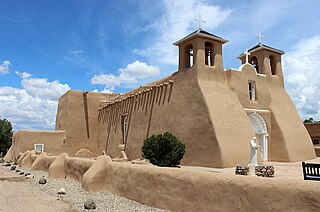
San Francisco de Asís Mission Church is a historic and architecturally significant building on the main plaza of Ranchos de Taos, New Mexico. Originally the center of a small Mexican and Indian 18th Century agricultural community. Built between 1772 and 1816 replacing an earlier church in that location. New Mexico was then part of the Vice-Royalty of New Spain. It is a fine example of a New Mexico Spanish Colonial Church, and is a popular subject for artists. It was designated a National Historic Landmark in 1970. It is a parish church of the Roman Catholic Archdiocese of Santa Fe.

Ranchos de Taos Plaza is a historic district in Ranchos de Taos, New Mexico, about four miles south of the town of Taos, New Mexico. There are 21 buildings over 84 acres in the historic district, including the San Francisco de Assisi Mission Church, a U.S. National Historic Landmark.
The 56-mile (90 km) High Road to Taos is a scenic, winding road through the Sangre de Cristo Mountains between Santa Fe and Taos.. It winds through high desert, mountains, forests, small farms, and tiny Spanish land grant villages and Pueblo Indian villages. Scattered along the way are the galleries and studios of traditional artisans and artists drawn by the natural beauty. It has been recognized by the state of New Mexico as an official scenic byway.

Taos Inn is an historic inn located in Taos, New Mexico. It is made up of several adobe houses dating from the 19th century, one of which was a home of Thomas "Doc" Martin which hosted the formative meeting of the Taos Society of Artists in 1915. After Doc's death, his widow Helen Martin converted the houses into a hotel, which opened on June 7, 1936 as Hotel Martin. The name was changed to "Taos Inn" by subsequent owners.

The Governor Bent House is the historic home of Governor Charles Bent who served as the first United States territorial governor of New Mexico.

Van Campen's Inn or Isaac Van Campen Inn is a fieldstone residence that was used as a yaugh house during the American colonial era. Located in Walpack Township, Sussex County, New Jersey along the Delaware River, it is a historic site located along the Old Mine Road in the Delaware Water Gap National Recreation Area. It is operated under a memorandum of understanding between the National Park Service and the Walpack Historical Society, a local non-profit corporation.

The Poppy Peak Historic District is a neighborhood and historic district located in the southwest corner of Pasadena, California. The neighborhood is located on the side of Poppy Peak, a 991-foot-high (302 m) mountain of the San Rafael Hills. Developer William Carr platted the neighborhood in 1924. The homes in the district were designed by a number of significant Modern Movement architects. The district was added to the National Register of Historic Places in 2009.
Anton Chico, or Anton Chico Abajo or Anton Chico de Abajo, is a census-designated place in Guadalupe County, New Mexico, United States. Its population was 188 as of the 2010 census, of which 167 were Hispanic in origin. Anton Chico has a post office with ZIP code 87711. New Mexico State Road 386 passes through the community. Anton Chico is listed in the National Register of Historic Places.

Taos Downtown Historic District is a historic district in Taos, New Mexico. Taos "played a major role in the development of New Mexico, under Spanish, Mexican, and American governments." It is a key historical feature of the Enchanted Circle Scenic Byway of northern New Mexico.

Our Lady of Guadalupe Parish or Nuestra Senora de Guadalupe is located just west of the Taos Plaza at 205 Don Fernando Street in downtown Taos, New Mexico.

The Downtown Neighborhood is a neighborhood in Albuquerque, New Mexico, located between Downtown and Old Town. It is sometimes known as the Fourth Ward based on Albuquerque's former system of political wards. The neighborhood is a mostly residential area consisting largely of single-family dwellings in various sizes and styles constructed between the 1880s and 1940s. There is also a commercial district along Central Avenue which has been branded since 2017 as West Downtown.

The district is a rectangular, open plaza with buildings on four sides. The most notable is the eighteenth-century La Iglesia de Santa Cruz. The plaza is also outlined on three sides and crossed diagonally by South McCurdy Road. Facing it are the church and four related features; four dwellings; one functioning and one nonfunctioning store; the Santa Cruz Irrigation District office; a vacant building; and three sites of former buildings, one in ruins. The Holy Cross Church, a Spanish-Colonial, adobe edifice dominates the west side. The ‘’Ortega House’’, a relatively large, contributing, New Mexico Vernacular building is on the south. To the east are three noncontributing dwellings and on the north three noncontributing buildings. Most of the buildings facing the plaza are cement plastered in an adobe shade of brown. The plaza itself and the principal buildings have retained architectural integrity and represent their historical associations. The buildings on the remaining two sides were built or altered after the Period of Significance. Sites of former buildings on the south and east sides contain varying potential for archaeological investigation.