
Fort Wayne is a city in the U.S. state of Indiana and the seat of Allen County, United States. Located in northeastern Indiana, the city is 18 miles (29 km) west of the Ohio border and 50 miles (80 km) south of the Michigan border. The city's population was 270,402 as of the 2019 Census estimate making it the second-most populous city in Indiana after Indianapolis, and the 75th-most populous city in the United States. It is the principal city of the Fort Wayne metropolitan area, consisting of Allen, Wells, and Whitley counties, a combined population of 419,453 as of 2011. Fort Wayne is the cultural and economic center of northeastern Indiana. In addition to the three core counties, the combined statistical area (CSA) includes Adams, DeKalb, Huntington, Noble, and Steuben counties, with an estimated population of 615,077.

New Haven is a city in Adams, Jefferson, and St. Joseph townships, Allen County, Indiana, United States. It sits to the east of the city of Fort Wayne, the second largest city in Indiana, and is situated mostly along the southern banks of the Maumee River. The population was 14,794 as of the 2010 census.

The Wabash and Erie Canal was a shipping canal that linked the Great Lakes to the Ohio River via an artificial waterway. The canal provided traders with access from the Great Lakes all the way to the Gulf of Mexico. Over 460 miles long, it was the longest canal ever built in North America.
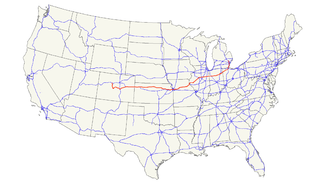
U.S. Route 24 is one of the original United States highways of 1926. It originally ran from Pontiac, Michigan, in the east to Kansas City, Missouri, in the west. Today, the highway's eastern terminus is in Independence Township, Michigan, at an intersection with I-75 and its western terminus is near Minturn, Colorado at an intersection with I-70. The highway transitions from north–south to east–west signage at the Ohio-Michigan state line.

Downtown Pittsburgh, colloquially referred to as the Golden Triangle, and officially the Central Business District, is the urban downtown center of Pittsburgh. It is located at the confluence of the Allegheny River and the Monongahela River whose joining forms the Ohio River. The "triangle" is bounded by the two rivers. The area features offices for major corporations such as PNC Bank, U.S. Steel, PPG, Bank of New York Mellon, Heinz, Federated Investors and Alcoa. It is where the fortunes of such industrial barons as Andrew Carnegie, Henry Clay Frick, Henry J. Heinz, Andrew Mellon and George Westinghouse were made. It contains the site where the French fort, Fort Duquesne, once stood.
The Millionaires' Mile, Millionaire's Mile, Millionaires' Row, Millionaire's Row, Billionaires Row, Golden Mile or Alpha Street are the exclusive residential neighborhoods of various cities, often along one scenic strip such as a riverside or hilltop drive, or a wide city boulevard.

Woodbridge is a historic neighborhood of primarily Victorian homes located in Detroit, Michigan. The district was listed on the National Register of Historic Places in 1980, with later boundary increases in 1997 and 2008. In addition to its historic value, Woodbridge is also notable for being an intact neighborhood of turn-of-the-century homes within walking or biking distance of Detroit's Downtown, Midtown, New Center, and Corktown neighborhoods.

Fort Miami (Miamis) was a British fort built in spring 1794 on the Maumee River in what was at the time territory of the United States, and designated by the federal government as the Northwest Territory. The fort was located at the eastern edge of present-day Maumee, Ohio, southwest of Toledo. The British built the fort to forestall a putative assault on Fort Detroit by Gen. "Mad" Anthony Wayne's army, then advancing northward in southwestern Ohio
State Road 930 (SR 930) is an Indiana State Road that runs between Fort Wayne and New Haven in the US state of Indiana. The 12.97 miles (20.87 km) of SR 930 serve as a connection with U.S. Route 30 (US 30) through these two cities between the beginning of the concurrency with Interstate 69 (I-69) in Fort Wayne and the end of its concurrency with I-469 in New Haven. All of the highway is listed on the National Highway System. Various sections are urban two-lane highway, urbanized four-lane divided highway, and urbanized six-lane divided highway. The highway passes through industrial and commercial properties. SR 930 was designated in 1998, and replaced segments of US 30 in Fort Wayne and New Haven that were formerly part of the Lincoln Highway in the 1920s, as well as Coliseum Boulevard, which was designated as part of US 30 in the 1950s.

Washington Boulevard Historic District is a multi-block area of downtown Detroit, Michigan. It consists of structures facing Washington Boulevard between State and Clifford Streets. In 1982, it was added to the National Register of Historic Places. It includes the Book-Cadillac Hotel, the Book Tower, the Industrial Building, and Detroit City Apartments among other architecturally significant buildings. Washington Boulevard is one of the city's main boulevards and part of Augustus Woodward's 1807-design for the city. Because Woodward's plan was never completed, the boulevard contains a sharp curve south of Michigan Avenue where it was connected to an existing street.
U.S. Route 24 in Indiana runs east from the Illinois state line to Huntington. At Huntington, US 24 turns northeast and runs to Fort Wayne; it then runs concurrently with Interstate 69 (I-69) and I-469 to bypass the city before entering Ohio at the state line east of Fort Wayne. The segment of US 24 between Logansport and Toledo, Ohio is part of the Hoosier Heartland Industrial Corridor project of the Intermodal Surface Transportation Efficiency Act.

The Lakewood Balmoral Historic District is a historic district in the Edgewater community area of Chicago, Illinois. It was listed on the National Register of Historic Places on February 12, 1999. The district covers an area of about 63 acres (0.25 km2); its boundaries are Magnolia Avenue to the east, Wayne Avenue to the west, Foster Avenue to the south, and Bryn Mawr Avenue to the north.

The Rivergreenway is the backbone of burgeoning Fort Wayne Trails network in Fort Wayne, Indiana and the surrounding area. The Rivergreenway consists of nearly 25-miles of connected trails through a linear park following alongside or near the City's three rivers: St. Joseph River, St. Marys River, and Maumee River. In 2009, the Rivergreenway was designated as a National Recreation Trail. The trail network also connects to the Wabash & Erie Canal Towpath Trail. In 2011, the Wabash & Erie Canal Towpath Trail was completed, the Greater Fort Wayne has 50 miles of connected trails.

The Indianapolis Park and Boulevard System is a group of parks, parkways, and boulevards in Indianapolis, Indiana, that was designed by landscape architect George Edward Kessler in the early part of the twentieth century. Also known as the Kessler System, the district includes 3,474 acres (1,406 ha) and has shaped the city through the present day. This historic district was added to the National Register of Historic Places in 2003.

The John Claus Peters House is a historic home at 832 West Wayne Street in Fort Wayne, Indiana. It was added to the National Register of Historic Places on September 17, 1980. It is part of Fort Wayne's West End Historic District. It was built in 1885 for Mary and John Claus Peters who had seven children. John Wing designed the Queen Anne style house. It has eight fireplaces.
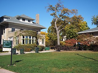
Berger Park, officially Park #1255 of the Chicago Park District, is a small recreational area bordering Lake Michigan in the Edgewater neighborhood of North Side, Chicago, Illinois. The park features the historic Downey House and Samuel H. Gunder houses.

North Anthony Boulevard Historic District is a national historic district located at Fort Wayne, Indiana. The district encompasses 296 contributing buildings in a predominantly residential section of Fort Wayne, extending along North Anthony Boulevard from Lake Avenue in the south to Vance Avenue in the north. An overlapping designation includes all of the rights of way in the district, plus those on the rest of North Anthony south to the Maumee River, as well as on South Anthony Boulevard south of the river.

Fort Wayne Park and Boulevard System Historic District is a national historic district located at Fort Wayne, Indiana. The district encompasses 34 contributing buildings, 61 contributing sites, 70 contributing structures, and 15 contributing objects in 11 public parks, four parkways, and ten boulevards associated with the parkway and boulevard system in Fort Wayne. The system was originally conceived in 1909 by Charles Mulford Robinson (1869–1917) and further developed and refined by noted landscape architect and planner George Kessler (1862-1923) in 1911–1912. The buildings reflect Classical Revival and Bungalow / American Craftsman style architecture. Later additions and modifications include those by noted landscape architect Arthur Asahel Shurcliff.

The Kensington Boulevard Historic District is a historic district on the National Register of Historic Places in Fort Wayne, Indiana, added in 2019. The district contains more than 170 homes built between 1917 and 1955, with one home dating to approximately 1870. The boundaries of the district stretch from Niagra Drive along Maumee River in the south to East State Boulevard, its present northern boundary. To the west, it is bounded by the North Anthony Boulevard Historic District, and to the east, by Pemberton Drive. The entire length of this portion of Kengsington features esplanades planted with trees. The district was platted in two separate phases, the south phase in 1917 and the north phase in 1921, on a grid plan.

