
Russell Cave National Monument is a U.S. national monument in northeastern Alabama, United States, close to the town of Bridgeport. The monument was established on May 11, 1961, when 310 acres (1.3 km2) of land were donated by the National Geographic Society to the American people. It is now administered and maintained by the National Park Service. The national monument was listed on the National Register of Historic Places on October 15, 1966.

The Grand Village of the Illinois, also called Old Kaskaskia Village, is a site significant for being the best documented historic Native American village in the Illinois River valley. It was a large agricultural and trading village of Native Americans of the Illinois confederacy, located on the north bank of the Illinois River near the present town of Utica, Illinois. French explorers Louis Joliet and Father Jacques Marquette came across it in 1673. The Kaskaskia, a tribe of the Illiniwek people lived in the village. It grew rapidly after a French mission and fur trading post were established there in 1675, to a population of about 6,000 people in about 460 houses. Around 1691 the Kaskaskia and other Illiniwek moved further south, abandoning the site due to pressure from an Iroquois invasion from the northeast.
Lamoka Lake, previously known as Mud Lake, is a small crescent-shaped lake in the western part of New York state. The lake is located at the border of Schuyler County and Steuben County. Most of the lake is in Schuyler County with only a small part, called "Mill Pond," at the southwest corner in Steuben County.

Copper Culture State Park is a 42-acre (17 ha) Wisconsin state park in Oconto, northeastern Wisconsin. The park has natural areas, farmlands, archaeological sites, and a Native American museum.

The Lindenmeier site is a stratified multi-component archaeological site most famous for its Folsom component. The former Lindenmeier Ranch is in the Soapstone Prairie Natural Area, in northeastern Larimer County, Colorado, United States. The site contains the most extensive Folsom culture campsite yet found with calibrated radiocarbon dates of c. 12,300 B.P.. Artifacts were also found from subsequent Archaic and Late pre-historic periods.

The Modoc Rock Shelter is a rock shelter or overhang located beneath the sandstone bluffs that form the eastern border of the Mississippi River floodplain at which Native American peoples lived for thousands of years. This site is significant for its archaeological evidence of thousands of years of human habitation during the Archaic period in the Eastern United States. It is located on the northeastern side of County Road 7 southeast of Prairie du Rocher in Randolph County, Illinois, United States. It was declared a National Historic Landmark in 1961.
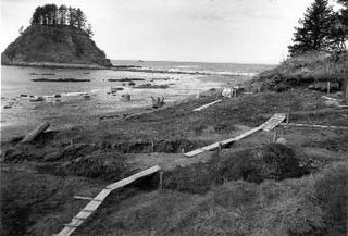
The Ozette Native American Village Archeological Site is the site of an archaeological excavation on the Olympic Peninsula near Neah Bay, Washington, United States. The site was a village occupied by the Ozette Makah people until a mudslide inundated the site around the year 1750. It is located in the now unpopulated Ozette Native American Reservation.

The Sommerheim Park Archaeological District includes a group of six archaeological sites west of Erie, Pennsylvania in the United States. The sites are in Sommerheim Park, one of the few undeveloped areas of the Lake Erie shoreline, in Millcreek Township. This district has been listed on the National Register of Historic Places. This is one of the leading archaeological sites in the Erie area and along the southern shoreline of Lake Erie, due to the amount of artifacts and the lack of disturbance on the site.
The Dodge Site is an archaeological site in the northwestern part of the U.S. state of Ohio. Located north of Bowling Green in Wood County, the site was inhabited by Middle Woodland and Upper Mississippian peoples. Among the artifacts discovered at the site are ceramics and stone tools. The site's stratigraphy is obvious: the Middle Woodland village site and cemetery can easily be distinguished from the Upper Mississippian occupation zone that sits on top of it. While only a small portion of the 2.2 acre (0.89 ha) site has been excavated, the artifacts that have been discovered at Dodge have contributed significantly to an understanding of the western basin of Lake Erie around AD 1300. Enough material has been recovered to facilitate radiometric dating, as well as identifying the peoples who once inhabited the site. The excavations also revealed the intensity of occupation: the Middle Woodland layer was substantially larger than the exceptionally thin Upper Mississippian component.

The LoDaisKa site is a prominent archaeological site in the U.S. state of Colorado, located within a rockshelter near Morrison. The rockshelter was first inhabited by people of the Archaic through the Middle Ceramic period, generally spanning 3000 BC to 1000 AD.

Franktown Cave is located 25 miles (40 km) south of Denver, Colorado on the north edge of the Palmer Divide. It is the largest rock shelter documented on the Palmer Divide, which contains artifacts from many prehistoric cultures. Prehistoric hunter-gatherers occupied Franktown Cave intermittently for 8,000 years beginning about 6400 BC The site held remarkable lithic and ceramic artifacts, but it is better known for its perishable artifacts, including animal hides, wood, fiber and corn. Material goods were produced for their comfort, task-simplification and religious celebration. There is evidence of the site being a campsite or dwelling as recently as AD 1725.

The Magic Mountain site is an Archaic and Woodland village site in Jefferson County, Colorado dating from 4999 BC to 1000 AD. The site was added to the National Register of Historic Places in 1980.
The Trinchera Cave Archeological District (5LA9555) is an archaeological site in Las Animas County, Colorado with artifacts primarily dating from 1000 BC to AD 1749, although there were some Archaic period artifacts found. The site was added to the National Register of Historic Places in 2001 and is located on State Trust Lands.

Lamb Spring is a pre-Clovis prehistoric Paleo-Indian archaeological site located in Douglas County, Colorado with the largest collection of Columbian mammoth bones in the state. Lamb Spring also provides evidence of Paleo-Indian hunting in a later period by the Cody culture complex group. Lamb Spring was listed in 1997 on the National Register of Historic Places.

The Riverside Site, also known as 20-ME-1, is an archaeological site located near the Riverside Cemetery in Menominee, Michigan. It was listed on the National Register of Historic Places in 1978.
The Skegemog Point Site, also known as the Samels Field Site or Samels Site and designated 20GT2, is an archaeological site located on the property of the Samels Farm at 8298 Skegemog Point Road, near Williamsburg, Michigan. Material at the site spans over 10,000 years, and the site is unique in that, due to glacial rebound, it is horizontally stratified rather than vertically stratified. The site was listed on the National Register of Historic Places in 1972.
The St. Croix River Access Site is a prehistoric Native American archaeological site on the St. Croix River in Stillwater Township, Minnesota, United States. It consists of a habitation site with a large quantity of stone tool artifacts, occupied from roughly 800 to 1700 CE. It was listed on the National Register of Historic Places in 1984 for having local significance in the theme of archaeology. It was nominated for its scientific potential to illuminate Late Woodland period cultural relationships, lithic technology, and resource use.
The Sebre Lake Site is a prehistoric Native American archaeological site in Fort Ripley Township, Minnesota, United States. It has yielded habitation and burial features accumulated over 4,000 years of intermittent use from the mid-Archaic to the early Late Woodland period. The site was listed on the National Register of Historic Places in 1984 for having local significance in the theme of archaeology. It was nominated for being one of the richest archaeological sites in the Nokasippi River Valley.

The Moccasin Bluff site is an archaeological site located along the Red Bud Trail and the St. Joseph River north of Buchanan, Michigan. It was listed on the National Register of Historic Places in 1977, and has been classified as a multi-component prehistoric site with the major component dating to the Late Woodland/Upper Mississippian period.
21SL55 is a precontact Native American archaeological site in the Boundary Waters of northern Minnesota, United States. It was occupied by the Blackduck culture of the late Woodland period sometime between 700 and 1500 C.E. Located on a small island in what is now Voyageurs National Park, the site is known only by its Smithsonian trinomial. It contains well-preserved faunal remains, a possible ricing jig, and other subsurface features.

