Azad Jammu and Kashmir, abbreviated as AJK and colloquially referred to as simply Azad Kashmir, is a region administered by Pakistan as a nominally self-governing entity and constituting the western portion of the larger Kashmir region, which has been the subject of a dispute between India and Pakistan since 1947. Azad Kashmir also shares borders with the Pakistani provinces of Punjab and Khyber Pakhtunkhwa to the south and west, respectively. On its eastern side, Azad Kashmir is separated from the Indian union territory of Jammu and Kashmir by the Line of Control (LoC), which serves as the de facto border between the Indian- and Pakistani-controlled parts of Kashmir. Geographically, it covers a total area of 13,297 km2 (5,134 sq mi) and has a total population of 4,045,366 as per the 2017 national census.

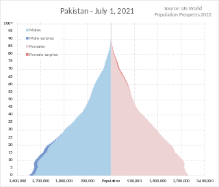
Pakistan had a population of 241,495,112 according to the final results of the 2023 Census. This figure includes Pakistan's four provinces e.g. Punjab, Sindh, KPK, Balochistan and Islamabad Capital Territory. AJK and Gilgit-Baltistan's census data is yet to be approved by CCI Council of Pakistan. Pakistan is the world's fifth most populous country.

The Srinagar District is an administrative district of Indian-administered Jammu and Kashmir in the disputed Kashmir region. It is one of the 20 districts of Jammu and Kashmir. Situated in the centre of the Kashmir Valley, it is the second-most populous district of the union territory after Jammu District as per the 2011 national census, and is home to the summer capital city of Srinagar. Likewise, the city of Srinagar also serves as the Srinagar District's headquarters.

The districts of Pakistan are the third-level administrative divisions of Pakistan, below provinces and divisions, but forming the first-tier of local government. In total, there are 166 districts in Pakistan, including the Capital Territory, and the districts of Azad Kashmir and Gilgit-Baltistan. These districts are further divided into tehsils and union councils.

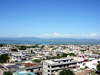
Muzaffarabad is a city in Pakistani-administered Azad Kashmir in the disputed Kashmir region. It is the largest city and the capital of Azad Kashmir, which is a Pakistani-administered administrative territory.

Mirpur, officially known as New Mirpur City, is the capital of Mirpur district located in Azad Kashmir, Pakistan which has been subject of the larger Kashmir dispute between Pakistan and India since 1947. It is the second largest city of Azad Kashmir and the 74th largest city in Pakistan.

Bagh District is a district of Pakistan-administered Azad Kashmir in the disputed Kashmir region. It is one of the ten districts of Azad Jammu and Kashmir. Previously part of Poonch District, Bagh was established as a separate district in 1988.

Bhimber District is a district of Pakistan-administered Azad Kashmir in the disputed Kashmir region. It is the southernmost of the 10 districts of Pakistan's territory of Azad Kashmir. It has an area of 1,516 km², and the district headquarter is the town of Bhimber.
The British Mirpuri community comprises people in the United Kingdom who originate from the Mirpur District and surrounding areas in Pakistan-administered Azad Jammu and Kashmir, thus being a part of the Mirpuri diaspora. While no accurate statistics are available, an estimated 60 to 70 per cent of British Pakistanis in England trace their origins to the administrative territory of Azad Kashmir in northeastern Pakistan, mainly from the Mirpur, Kotli and Bhimber districts.

Rawalakot is the capital of Poonch district in Azad Kashmir, Pakistan. It is located in the Pir Panjal Range.

Kotli is a city in Kotli District of Azad Jammu & Kashmir. It lies on the Poonch River, and the river contains several waterfalls, including the Lala Waterfall near the town of Kotli, and the Gulpur Waterfalls at the village of Gulpur to the southwest. As per the 2017 Census of Pakistan, Kotli had a population of 46,907.
The Census in Pakistan is a legally decennial census and a descriptive count of Pakistan's population on Census Day, and of their dwellings, conducted and supervised by the Pakistan Bureau of Statistics. The 2017 Census in Pakistan marks the first census to take place in Pakistan since 1998. The most recent census was the 2023 Pakistani census.

The 1998 Census of Pakistan was the fifth Pakistani national census. It provided a detailed enumeration of the population of Pakistan at the time it was conducted under the authority of the Pakistan Bureau of Statistics, an agency of the Government of Pakistan. According to the 1998 census, the population of Pakistan proper stood at 130,857,717 people. With the inclusion of the population of Azad Jammu & Kashmir and Gilgit-Baltistan, the population stood at 134,714,017 people. Despite being mandated by the Constitution of Pakistan to be held every 10 years, this was the first census to take place in Pakistan after the 1981 census that took place 17 years earlier, and the next census would not be held for another 19 years, until 2017. The inconsistencies in Pakistan's national elections are due in part to political turmoil and instability within the country.
Athmuqam or Athmakam is a tehsil of Neelum District in Azad Kashmir, Pakistan. It is situated about 73 kilometres (45 mi) from Muzaffarabad. Athmuqam is the headquarters of Neelum District. Its population was 7,922 in 2017.
The Kashmiri diaspora refers to Kashmiris who have migrated out of the Kashmir into other areas and countries, and their descendants.

The Kashmir division is a revenue and administrative division of the Indian-administered Jammu and Kashmir in the disputed Kashmir region. It comprises the Kashmir Valley, bordering the Jammu Division to the south and Ladakh to the east. The Line of Control forms its boundary with the Pakistani-administered territories of Gilgit−Baltistan and Azad Jammu and Kashmir to the north and west and west, respectively.
The Mirpuri diaspora constitutes individuals with an origin in the Mirpur District of Azad Kashmir, Pakistan, now living outside that district. Migration from Mirpur started occurring in the 1920s, when many Mirpuris left for Bombay to work on merchant ships. During the partition of British India in 1947, many Mirpuri Hindus and Mirpuri Sikhs were forced to flee to cities in the princely state of Jammu and Kashmir. The construction of the Mangla Dam by the Pakistani Government in the 1960s caused many of Mirpuri Muslims to migrate to the United Kingdom to work as labourers.
Barnala is a city located in the state of Azad Jammu & Kashmir, Pakistan. The word "Barnala" literally translates to Bar (Edge) and Nala (River), which means "on the edge of a river" and was a key location during the 1965 Battle of Chamb. It serves as a tehsil (sub-division) of the district Bhimber, Azad Jammu & Kashmir.


