Little Grass Valley | |
---|---|
![]() Little Grass Valley Reservoir as seen from atop nearby Bald Mountain | |
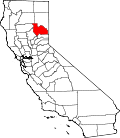
![]() Location in Plumas County and the state of California | |
Coordinates: 39°42′59″N120°58′35″W / 39.71639°N 120.97639°W [1] | |
Country | ![]() |
State | ![]() |
County | Plumas |
Area | |
• Total | 9.999 sq mi (25.897 km2) |
• Land | 9.999 sq mi (25.897 km2) |
• Water | 0 sq mi (0 km2) 0% |
Population | |
• Total | 25 |
• Density | 2.5/sq mi (0.97/km2) |
Time zone | UTC-8 (Pacific (PST)) |
• Summer (DST) | UTC-7 (PDT) |
ZIP code | 96053 |
Area code | 530 |
FIPS code | 06-41789 |
Little Grass Valley is a census-designated place in Plumas County, California, USA. As of the 2020 census, it had a total population of 25.
According to the United States Census Bureau, the CDP has a total area of 10.0 square miles (26 km2), all land. It is on the east side of the Little Grass Valley Reservoir, which covers about 1,600 acres (6.5 km2; 2.5 sq mi).
Census | Pop. | Note | %± |
---|---|---|---|
2000 | 0 | — | |
2010 | 2 | — | |
2020 | 25 | 1,150.0% | |
U.S. Decennial Census [4] 1860–1870 [5] [6] 1880-1890 [7] 1900 [8] 1910 [9] 1920 [10] 1930 [11] 1940 [12] 1950 [13] 1960 [14] 1970 [15] 1980 [16] 1990 [17] 2000 [18] 2010 [19] |
Little Grass Valley first appeared as a census designated place in the 2000 U.S. Census. [18]
Race / Ethnicity (NH = Non-Hispanic) | Pop 2000 [20] | Pop 2010 [21] | Pop 2020 [22] | % 2000 | % 2010 | % 2020 |
---|---|---|---|---|---|---|
White alone (NH) | 0 | 2 | 19 | 0.00% | 100.00% | 76.00% |
Black or African American alone (NH) | 0 | 0 | 0 | 0.00% | 0.00% | 0.00% |
Native American or Alaska Native alone (NH) | 0 | 0 | 0 | 0.00% | 0.00% | 0.00% |
Asian alone (NH) | 0 | 0 | 1 | 0.00% | 0.00% | 4.00% |
Native Hawaiian or Pacific Islander alone (NH) | 0 | 0 | 0 | 0.00% | 0.00% | 0.00% |
Other race alone (NH) | 0 | 0 | 0 | 0.00% | 0.00% | 0.00% |
Mixed race or Multiracial (NH) | 0 | 0 | 0 | 0.00% | 0.00% | 0.00% |
Hispanic or Latino (any race) | 0 | 0 | 5 | 0.00% | 0.00% | 20.00% |
Total | 0 | 2 | 25 | 100.00% | 100.00% | 100.00% |
The 2020 United States census reported that Little Grass Valley had a population of 25. The population density was 2.5 inhabitants per square mile (0.97/km2). Of the population, 19 people (76%) were White, 1 (4%) was Asian, and 5 (20%) were Hispanic or Latino. [23]
There were 11 households, of which 4 were families and 6 were one person living alone. [24] The median age was 57.5 years.
There were 147 housing units at an average density of 14.7 units per square mile (5.7 units/km2), of which 11 (7.5%) were occupied year round, and 136 (92.5%) were used seasonally. [23]
Little Grass Valley was initially occupied by the Maidu Native American tribe during the summers. During the California Gold Rush, it became a mining camp. The camp disappeared before 1900, but there are still gold mines in the area. The land in the valley was used to graze cattle and there was a Boy Scout Camp located on the banks of the South Fork of the Feather River. In 1963 the whole area was flooded and a lake filled the valley. Today there are campgrounds all around the lake, cabins on the south side, and it is the center of a snowmobiling area. It is about three miles (4.8 km) from La Porte (population 43).
In the state legislature, Little Grass Valley is in the 1st senatorial district , represented by Republican Megan Dahle, [25] and the 1st Assembly district , represented by Republican Heather Hadwick. [26]
Federally, Little Grass Valley is in California's 1st congressional district , represented by Republican Doug LaMalfa. [27]
About 2.5 miles (4.0 km) north of Little Grass Valley Lake lies a small, natural lily pond called Fowler Lake. Its coordinates are 39°46′27″N121°00′19″W / 39.77417°N 121.00528°W , and its altitude is 5,446 feet (1,660 m).
The school district is Plumas Unified School District. [28]